Regionalkarte
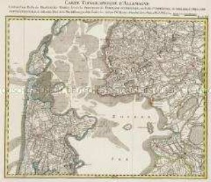
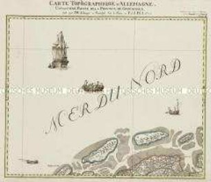
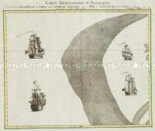
Grand Atlas . Bl. 19 (Holland, Nordsee): Contenant une Partie de la Comté d'Hollande, des Isles de Zeeland et de la Mer d'Allemagne
- Alternative title
-
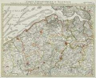
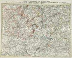
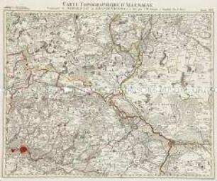
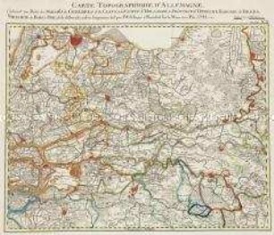
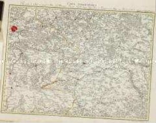
CARTE TOPOGRAPHIQUE D'ALLEMAGNE / Contenant une Partie de la COMTÉ d'HOLLANDE, des ISLES de ZEELAND et de la MER d'ALLEMAGNE
- Material/Technique
-
Papier, Kupferstich, koloriert, gebunden |Fadenheftung
- Measurements
-
Höhe x Breite: 56,5 x 78 cm, Höhe: 56,5 cm, Breite: 78 cm, Tiefe: 3 cm (Atlas)
Höhe x Breite: 56,5 x 78 cm (Blatt)
Höhe x Breite: 52 x 68 cm (Platte)
Höhe x Breite: 46 x 59 cm (Karte)
- Location
-
Deutsches Historisches Museum, Berlin
- Inventory number
-
Do 2006/1059.19
Subject (what)
Deutschland
Classification
Kartografie (Gattung)
Event
Herstellung
(who)
Verleger, Militärkartograph: Johann Wilhelm Abraham Jaeger
Stecher: Johann Michael Zell
Stecher: Johann Michael Zell
(where)
Frankfurt (Main) [historisch: Frankfurt, Reichsstadt], Deutschland
(when)
1784
- Rights
-
Deutsches Historisches Museum
- Last update
-
24.03.2023, 9:30 AM CET
Data provider
Object type
- Regionalkarte
Associated
- Verleger, Militärkartograph: Johann Wilhelm Abraham Jaeger
- Stecher: Johann Michael Zell
Time of origin
- 1784
Other Objects (12)
Grand Atlas . Bl. 11 (Holland, Westfriesland): Contenant une Partie des Provinces Unies, savoir la Province de Friesland Occidentale, une Partie d'Over Yssel, de Gueldre, d'Hollande Septentrionale, de differentes Isles de la Meer d'Allemagne, et du Zuider See.
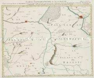
Grand Atlas . Bl. 18 (Polen. Gnesen): Contenant une Partie de Pologne, pour acclompir le Quarre de la grande Carte d'Allemagne, savoir les Palatinats de Gnesen, Inowrozlaw, et Brsestz.
Grand Atlas . Bl. 72 (Ungarn): Contenant une Partie du Royaume D'Hongrie
Grand Atlas . Bl. 77 (Grison, Tirol, Pludentz., Bormio): Contenant une Partie des Grisons, du Comté de Tyrol, du Comté de Pludentz, et le Comté de Bormio,
Grand Atlas . Bl. 2 (Groeningen): Contenant une Partie de la Province de Groeningen
Grand Atlas . Bl. 28 (Belgien, Flandern): Contenant une Partie de Pais Bas Autriches et de Flandre
Grand Atlas . Bl. 37 (Flandern...): Contenant une Partie de Flandre, du Comté d'Artois, de Picardie du Haynaut, et le Pais de Cambresis et et
Grand Atlas . Bl. 10 (Nordsee): Contenante le Grand Banc de Sable, appellè De Bree Vertien, dans la Mer d'Allemagne.
Grand Atlas . Bl. 16 (Brandenburg): Conténant le Margraviat de Brandenbourg et. et
Grand Atlas . Bl. 20 (Geldern, Cleve, Holland, Utrecht): Contenant une Partie des Duchés de Gueldres et de Cleves du Comté d'Hollande, la Province d'Utrecht, Baronie de Breda, Metairie de Bois le Duc, et de differentes autres Seigneuries
Grand Atlas . Bl. 55 (Frankreich): Pour servir de Suite au grand Atlas d'Allemagne
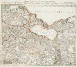
Grand Atlas, Bl. 7 (Pommern, Preussen) : Contenant une Partie du Duché de Pomeranie de Suedois et de Prusse.
Grand Atlas . Bl. 11 (Holland, Westfriesland): Contenant une Partie des Provinces Unies, savoir la Province de Friesland Occidentale, une Partie d'Over Yssel, de Gueldre, d'Hollande Septentrionale, de differentes Isles de la Meer d'Allemagne, et du Zuider See.
Grand Atlas . Bl. 18 (Polen. Gnesen): Contenant une Partie de Pologne, pour acclompir le Quarre de la grande Carte d'Allemagne, savoir les Palatinats de Gnesen, Inowrozlaw, et Brsestz.
Grand Atlas . Bl. 72 (Ungarn): Contenant une Partie du Royaume D'Hongrie
Grand Atlas . Bl. 77 (Grison, Tirol, Pludentz., Bormio): Contenant une Partie des Grisons, du Comté de Tyrol, du Comté de Pludentz, et le Comté de Bormio,
Grand Atlas . Bl. 2 (Groeningen): Contenant une Partie de la Province de Groeningen
Grand Atlas . Bl. 28 (Belgien, Flandern): Contenant une Partie de Pais Bas Autriches et de Flandre
Grand Atlas . Bl. 37 (Flandern...): Contenant une Partie de Flandre, du Comté d'Artois, de Picardie du Haynaut, et le Pais de Cambresis et et
Grand Atlas . Bl. 10 (Nordsee): Contenante le Grand Banc de Sable, appellè De Bree Vertien, dans la Mer d'Allemagne.
Grand Atlas . Bl. 16 (Brandenburg): Conténant le Margraviat de Brandenbourg et. et
Grand Atlas . Bl. 20 (Geldern, Cleve, Holland, Utrecht): Contenant une Partie des Duchés de Gueldres et de Cleves du Comté d'Hollande, la Province d'Utrecht, Baronie de Breda, Metairie de Bois le Duc, et de differentes autres Seigneuries
Grand Atlas . Bl. 55 (Frankreich): Pour servir de Suite au grand Atlas d'Allemagne