Regionalkarte
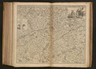
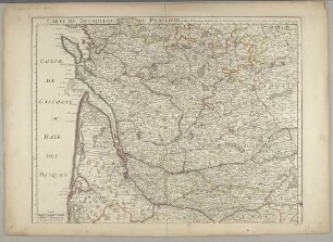
Grand Atlas . Bl. 37 (Flandern...): Contenant une Partie de Flandre, du Comté d'Artois, de Picardie du Haynaut, et le Pais de Cambresis et et
- Alternativer Titel
-
CARTE TOPOGRAPHIQUE D'ALLEMAGNE / Contenant une Partie de FLANDRE, du COMTÉ d'ARTOIS, de PICARDIE du HAYNAUT, et le PAIS de CAMBRESIS et et
- Standort
-
Deutsches Historisches Museum, Berlin
- Inventarnummer
-
Do 2006/1059.37
- Maße
-
Höhe x Breite: 56,5 x 78 cm, Höhe: 56,5 cm, Breite: 78 cm, Tiefe: 3 cm (Atlas)
Höhe x Breite: 56,5 x 78 cm (Blatt)
Höhe x Breite: 52 x 68 cm (Platte)
Höhe x Breite: 46 x 59 cm (Karte)
- Material/Technik
-
Papier, Kupferstich, koloriert, gebunden |Fadenheftung
- Klassifikation
-
Kartografie (Gattung)
- Bezug (was)
-
Deutschland
- Ereignis
-
Herstellung
- (wer)
-
Verleger, Militärkartograph: Johann Wilhelm Abraham Jaeger
- (wo)
-
Frankfurt (Main) [historisch: Frankfurt, Reichsstadt], Deutschland
- (wann)
-
1787
- Rechteinformation
-
Deutsches Historisches Museum
- Letzte Aktualisierung
-
24.03.2023, 09:31 MEZ
Datenpartner
Dieses Objekt wird bereitgestellt von:
Stiftung Deutsches Historisches Museum. Bei Fragen zum Objekt wenden Sie sich bitte an den Datenpartner.
Stiftung Deutsches Historisches Museum. Bei Fragen zum Objekt wenden Sie sich bitte an den Datenpartner.
Objekttyp
- Regionalkarte
Beteiligte
- Verleger, Militärkartograph: Johann Wilhelm Abraham Jaeger
Entstanden
- 1787
Ähnliche Objekte (12)

Sénac de Meilhan et l'intendance du Hainaut et du Cambrésis sous Louis XVI. Thèse

Comtés De Hainaut, Et De Cambrésis : avec les confins Du Comté De Flandre, Du Duché De Brabant, Du Comté De Namur, et une partie De La Seigneurie De Liége ; Avec Privilege

Arrest du Conseil Provincial Et Superieur D'Artois : Du 29 Mai 1762

Arrest du conseil provincial et supérieur d'Artois, du 29 Mai 1762

Le traité de Cateau-Cambrésis : 2 et 3 avril 1559
Comitatus Hannoniae et Episcopatus Cambresis Descriptio

Correspondance intime du Comte de Vaudreuil et du Comte d'Artois pendant l'émigration (1789 - 1815), 2

Correspondance intime du Comte de Vaudreuil et du Comte d'Artois pendant l'émigration (1789 - 1815), 1
Carte d'Artois et des environs : on lon voit le Ressort du Conseil Provinicial d'Artois

Noblesse & chevalerie du comté de Flandre, d'Artois & de Picardie

Le livre du très chevalereux comte d'Artois et de sa femme, fille au comte de Boulogne

Plan de Chateau en Cambresis
Sénac de Meilhan et l'intendance du Hainaut et du Cambrésis sous Louis XVI. Thèse
Comtés De Hainaut, Et De Cambrésis : avec les confins Du Comté De Flandre, Du Duché De Brabant, Du Comté De Namur, et une partie De La Seigneurie De Liége ; Avec Privilege
Arrest du Conseil Provincial Et Superieur D'Artois : Du 29 Mai 1762
Arrest du conseil provincial et supérieur d'Artois, du 29 Mai 1762
Le traité de Cateau-Cambrésis : 2 et 3 avril 1559
Comitatus Hannoniae et Episcopatus Cambresis Descriptio
Correspondance intime du Comte de Vaudreuil et du Comte d'Artois pendant l'émigration (1789 - 1815), 2
Correspondance intime du Comte de Vaudreuil et du Comte d'Artois pendant l'émigration (1789 - 1815), 1
Carte d'Artois et des environs : on lon voit le Ressort du Conseil Provinicial d'Artois
Noblesse & chevalerie du comté de Flandre, d'Artois & de Picardie
Le livre du très chevalereux comte d'Artois et de sa femme, fille au comte de Boulogne