Monografie
Ethnographische Karte des Osmanischen Reichs europäischen Theils und von Griechenland
- Extent
-
1 Kt.
- Notes
-
Nullmeridian: Paris. - Maßstab auch in graph. Form (Deutsche Meilen, Türkische Berri). - Mit Völker-Tafel. - Oben links: Berghaus' Physikal. Atlas, oben links: 8te Abtheilung: Ehtnographie No. 19
- Location
-
München, Bayerische Staatsbibliothek -- Hbks/E 34 o-3#Kt.77
- Series
-
Physikalischer Atlas oder Sammlung von Karten / Berghaus, Heinrich C.; 3-77
Subject
Bevölkerung ; Osmanisches Reich / Europäischer Teil; Altkarte
Contributor
Published
Gotha : J. Perthes, 1847
- URN
-
urn:nbn:de:bvb:12-bsb00095407-1
- Last update
-
16.04.2024, 1:54 PM CEST
Time of origin
- Gotha : J. Perthes, 1847
Other Objects (12)
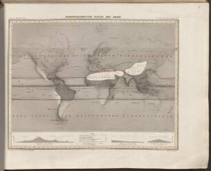
Hyetographische Karte Der Erde
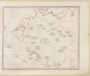
Botanische Karte von Deutschland : enthaltend die Statistik der vornehmsten Pflanzen-Familien so wie die Isotheren und Isochimenen
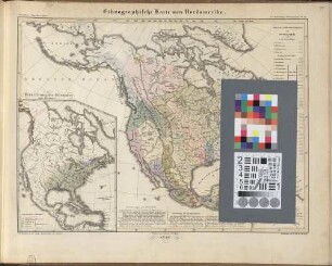
Ethnographische Karte von Nordamerika
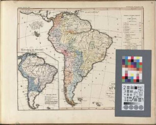
Ethnographische Karte von Süd-Amerika
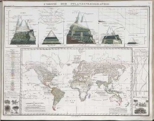
Umrisse Der Pflanzengeographie
![Physikalischer Atlas oder Sammlung von Karten : auf denen die hauptsächlichen Erscheinungen der anorganischen und organischen Natur nach ihrer geographischen Verbreitung und Vertheilung bildblich dargestellt sind, [Text]](https://iiif.deutsche-digitale-bibliothek.de/image/2/a095baf8-8b38-44c8-9e8c-700335ba8e7f/full/!306,450/0/default.jpg)
Physikalischer Atlas oder Sammlung von Karten : auf denen die hauptsächlichen Erscheinungen der anorganischen und organischen Natur nach ihrer geographischen Verbreitung und Vertheilung bildblich dargestellt sind, [Text]
Schul-Atlas der Alten Welt : nach Mannert, Ukert, Reichard, Kruse, Wilhelm u.A. bearbeitet
![13: Reduzirte Karte Von Den Philippinen und den Sulu Inseln : [gewidmet] Alexandroś Malaspina, Espinos y Telloś, Ildefonso de Aragon](https://iiif.deutsche-digitale-bibliothek.de/image/2/6419aa60-e485-4f5a-9e88-23e8d9d74206/full/!306,450/0/default.jpg)
13: Reduzirte Karte Von Den Philippinen und den Sulu Inseln : [gewidmet] Alexandroś Malaspina, Espinos y Telloś, Ildefonso de Aragon
Schulatlas der Alten Welt

"Bundesrepublik Deutschland" physisch und politisch Ausf.-Art: Farbiger Druck Herst.: Justus Perthes Format: 123 x 99,5 cm Maßstab: 1 : 830 000
"Bundesrepublik Deutschland" physisch und politisch Ausf.-Art: Farbiger Druck Herst.: Justus Perthes Format: 123 x 99,5 cm Maßstab: 1 : 830 000
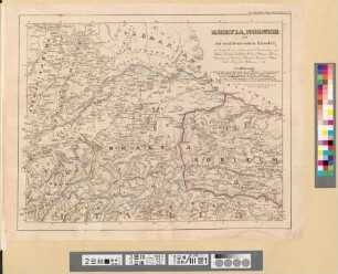
Rhaetia, Noricum und die angränzenden Länder
Hyetographische Karte Der Erde
Botanische Karte von Deutschland : enthaltend die Statistik der vornehmsten Pflanzen-Familien so wie die Isotheren und Isochimenen
Ethnographische Karte von Nordamerika
Ethnographische Karte von Süd-Amerika
Umrisse Der Pflanzengeographie
Physikalischer Atlas oder Sammlung von Karten : auf denen die hauptsächlichen Erscheinungen der anorganischen und organischen Natur nach ihrer geographischen Verbreitung und Vertheilung bildblich dargestellt sind, [Text]
Schul-Atlas der Alten Welt : nach Mannert, Ukert, Reichard, Kruse, Wilhelm u.A. bearbeitet
13: Reduzirte Karte Von Den Philippinen und den Sulu Inseln : [gewidmet] Alexandroś Malaspina, Espinos y Telloś, Ildefonso de Aragon
Schulatlas der Alten Welt
"Bundesrepublik Deutschland" physisch und politisch Ausf.-Art: Farbiger Druck Herst.: Justus Perthes Format: 123 x 99,5 cm Maßstab: 1 : 830 000
"Bundesrepublik Deutschland" physisch und politisch Ausf.-Art: Farbiger Druck Herst.: Justus Perthes Format: 123 x 99,5 cm Maßstab: 1 : 830 000