Druck | Gebietskarte | Inselkarte | Landkarte
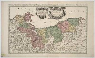
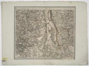
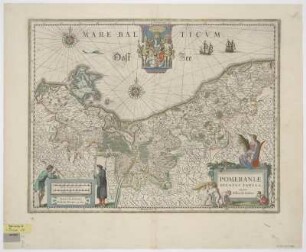
Karte von dem Herzogtum Pommern, 1:2 000 000, Kupferstich, um 1697
Duché De Pomeranie. - [Ca. 1:2 000 000]. - [Paris] : [Nicolas de Fer] , [um 1697]. - 1 Kt. : Kupferst. ; 25 x 18 cm. Maßstab in graph. Form (Lieues communes d'Allemagne, Lieues communes de France). - Titel- u. Maßstabskartusche unten links. - Mit Darstellung e. Seeschlacht in d. Ostsee. - Inselkt. - Mit Kt.-Netz. - Oben rechts: 79
in color
- Measurements
-
25 x 18 cm; 1:2000000 (Maßstab)
- Location
-
Sächsische Landesbibliothek - Staats- und Universitätsbibliothek Dresden (SLUB)
SLUB/Kartensammlung
- Inventory number
-
SLUB/KS A12861
- Other number(s)
-
90010557 (Dokumentnummer)
df_dk_0011287 (Aufnahmenummer)
Subject (what)
Grenzen
Küste
Seegefecht
Schiffe
Druckgrafik
Küste
Seegefecht
Schiffe
Druckgrafik
Subject (where)
Pommern (Landschaft) (Dargestellter Ort)
Subject (event)
Herstellung (Abgebildetes Objekt)
Classification
Druckgrafik (Gattung)
Event
Herstellung
(when)
2009
(description)
Aufnahme
Event
Digitalisierung
(description)
DFG-Karten
- Last update
-
31.03.2023, 11:10 AM CEST
Object type
- Druck; Landkarte; Gebietskarte; Inselkarte
Time of origin
- 2009
Other Objects (12)
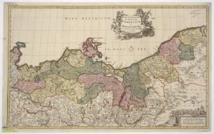
Karte von dem Herzogtum Pommern, 1:560 000, Kupferstich, 1691
Karte von dem Herzogtum Berg, 1:230 000, Kupferstich, 1700
Karte der Grafschaft Erbach im Odenwald, Franken, 1:450 000, Kupferstich, ab 1701
Karte von dem Herzogtum Stormarn, 1:200 000, Kupferstich, um 1700
Karte von Sund- und Breisgau mit angrenzenden Ländern, 1:160 000, Kupferstich, 1708
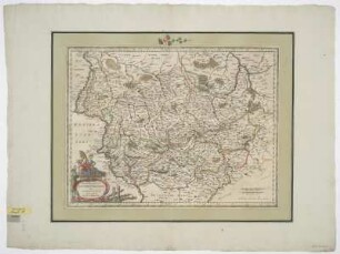
Territorialkarte der Grafschaft Glatz, 1:1 330 000, Kupferstich, um 1759
Karte von dem Schwäbischen Reichskreis, 1:520 000, Kupferstich, um 1729
Karte von Pommern, 1:120 000, Kupferstich, um 1573
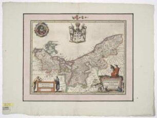
Karte der Herzogtümer Pommern und Mecklenburg, 1:790 000, Kupferstich, nach 1676
Karte von dem Herzogtum Pommern, 1:940 000, Kupferstich, um 1644
Karte von dem Herzogtum Pommern, 1:940 000, Kupferstich, um 1630
Karte von dem Erzbistum Magdeburg und dem Herzogtum Anhalt, 1:680 000, Kupferstich, um 1640
Karte von dem Herzogtum Pommern, 1:560 000, Kupferstich, 1691
Karte von dem Herzogtum Berg, 1:230 000, Kupferstich, 1700
Karte der Grafschaft Erbach im Odenwald, Franken, 1:450 000, Kupferstich, ab 1701
Karte von dem Herzogtum Stormarn, 1:200 000, Kupferstich, um 1700
Karte von Sund- und Breisgau mit angrenzenden Ländern, 1:160 000, Kupferstich, 1708
Territorialkarte der Grafschaft Glatz, 1:1 330 000, Kupferstich, um 1759
Karte von dem Schwäbischen Reichskreis, 1:520 000, Kupferstich, um 1729
Karte von Pommern, 1:120 000, Kupferstich, um 1573
Karte der Herzogtümer Pommern und Mecklenburg, 1:790 000, Kupferstich, nach 1676
Karte von dem Herzogtum Pommern, 1:940 000, Kupferstich, um 1644
Karte von dem Herzogtum Pommern, 1:940 000, Kupferstich, um 1630