- Location
-
Universitätsbibliothek Heidelberg
- Collection
-
UB Graphische Sammlung
- Inventory number
-
Graph. Slg. A_0403
- Measurements
-
B 26,2 cm, H 18,2 cm (Bild); stark beschnitten, montiert auf B 30,5 cm, H 23cm (Blatt)
- Material/Technique
-
Radierung
- Inscription/Labeling
-
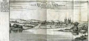
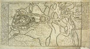
Inschrift: Plan von Manheim Mit seiner Neuen Fortification. (oben rechts im Bild: Titel und topographische Bezeichnung.)
Inschrift: G. Bodenehr fecit et excud. A. V. (unten rechts am Bild: Name des Radierers.)
- Classification
-
Karte (Gattung)
Batt'sche Sammlung (Lokale Systematik)
- Subject (what)
-
Stadtbefestigung
Stadtplan
Grundriss
- Subject (where)
-
Mannheim
- Event
-
Herstellung
- (where)
-
Augsburg
- (when)
-
ca. 1720
- Event
-
Veröffentlichung
- (who)
-
Bodenehr
- (when)
-
1720
- (description)
-
Des Curiosen Staats und Kriegs Theatri am Rhein
Bodenehr, Gabriel: Des Curiosen Staats und Kriegs Theatri am Rhein, anderer Theil, oder der Untere Rhein, durch unterschiedliche Geographische Topographische und Historische Land-Carten, Grundrisse und Prospect vorgestellet. Verlegt und zufinden bey Gabriel Bodenehr Kupfferstecher in Augspurg, ca. 1720, Taf. 59.
- Last update
-
05.03.2025, 4:23 PM CET
Data provider
This object is provided by:
Ruprecht-Karls-Universität Heidelberg. Universitätsbibliothek. If you have any questions about the object, please contact the data provider.
Ruprecht-Karls-Universität Heidelberg. Universitätsbibliothek. If you have any questions about the object, please contact the data provider.
Object type
- Grafik
Associated
Time of origin
- ca. 1720
- 1720
Other Objects (12)
Ansicht der Stadt Toul
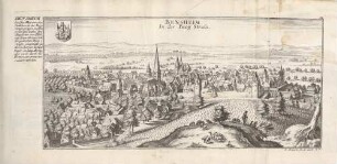
Bensheim an der Bergstraße

Neuburg an der Donau
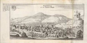
Weinheim an der Bergstrasse
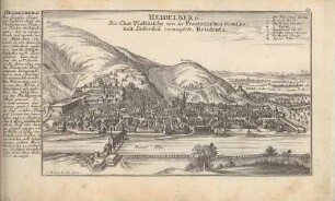
Heidelberg
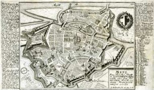
Plan der Stadt Metz
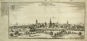
Ansicht der Stadt Bretten
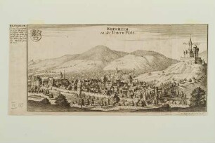
Weinheim
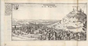
Heppenheim an der Bergstraße

Das PAULINER COLLEGIUM in LEIPZIG : Kupferstich
Plan der Stadt und der Zitadelle von Straßburg
Florenz, Stadtansicht
Ansicht der Stadt Toul
Bensheim an der Bergstraße
Neuburg an der Donau
Weinheim an der Bergstrasse
Heidelberg
Plan der Stadt Metz
Ansicht der Stadt Bretten
Weinheim
Heppenheim an der Bergstraße
Das PAULINER COLLEGIUM in LEIPZIG : Kupferstich
Plan der Stadt und der Zitadelle von Straßburg