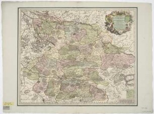
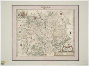
Druck | Landesaufnahme | Territorialkarte
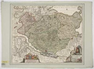
Karte vom Herzogtum Bremen und Fürstentum Verden, 1:330 000, Kupferstich, um 1710
Ducatus Bremae &[et] Ferdae Maximaeque partis Fluminis Visurgis Descriptio / per Fredericum De Wit. - [Ca. 1:330 000]. - Amstelodami : I. Cóvens et C. Mortier , [um 1710]. - 1 Kt. : Kupferstich ; 56 x 47 cm. Maßstab in graph. Form (Milliaria Germanica Communia, Milliaria Hispanica Communia). - Titelkartusche oben rechts, Maßstabskartusche unten links
in color
- Maße
-
56 x 47 cm; 1:330000 (Maßstab)
- Standort
-
Sächsische Landesbibliothek - Staats- und Universitätsbibliothek Dresden (SLUB)
SLUB/Kartensammlung
- Inventarnummer
-
SLUB/KS A14782
- Weitere Nummer(n)
-
90017169 (Dokumentnummer)
df_dk_0011343 (Aufnahmenummer)
Bezug (was)
Grenzen
Wappen
Druckgrafik
Wappen
Druckgrafik
Bezug (wo)
Oldenburg (Dargestellter Ort)
Bezug (Ereignis)
Herstellung (Abgebildetes Objekt)
Klassifikation
Druckgrafik (Gattung)
Ereignis
Herstellung
(wann)
2009
(Beschreibung)
Aufnahme
Ereignis
Digitalisierung
(Beschreibung)
DFG-Karten
- Letzte Aktualisierung
-
31.03.2023, 11:15 MESZ
Objekttyp
- Druck; Landesaufnahme; Territorialkarte
Entstanden
- 2009
Ähnliche Objekte (12)
Karte von dem Herzogtum Braunschweig-Lüneburg und der Grafschaft Dannenberg, 1:330 000, Kupferstich, um 1720
Karte von den Herzogtümern Bremen und Verden, 1:375 000, Kupferstich, um 1724
Karte von dem Niederrheinisch-Westfälischen Reichskreis, 1:820 000, Kupferstich, um 1666

Karte von Terra di Lavora (heute Gebiet südliches Lazio und nördliches Kampanien), ca. 1:330 000, Kupferstich, ab 1673
Karte von dem Herzogtum Mecklenburg, 1:520 000, Kupferstich, um 1683
Karte von Holstein und angrenzenden Herzogtümern, 1:310 000, Kupferstich, nach 1705
Karte von dem Herzogtum Mecklenburg, 1:460 000, Kupferstich, um 1706
Karte vom Niedersächsischen Reichskreis, 1:820 000, Kupferstich, ab 1725
Karte von dem Niederrheinisch-Westfälischen Reichskreis, 1:750 000, Kupferstich, um 1650
Karte vom Hochstift Hildesheim, Kupferstich, um 1650
Karte von dem Herzogtum Braunschweig-Lüneburg, 1:470 000, Kupferstich, um 1695
Karte von dem Herzogtum Pommern, 1:780 000, Kupferstich, um 1710
Karte von dem Herzogtum Braunschweig-Lüneburg und der Grafschaft Dannenberg, 1:330 000, Kupferstich, um 1720
Karte von den Herzogtümern Bremen und Verden, 1:375 000, Kupferstich, um 1724
Karte von dem Niederrheinisch-Westfälischen Reichskreis, 1:820 000, Kupferstich, um 1666
Karte von Terra di Lavora (heute Gebiet südliches Lazio und nördliches Kampanien), ca. 1:330 000, Kupferstich, ab 1673
Karte von dem Herzogtum Mecklenburg, 1:520 000, Kupferstich, um 1683
Karte von Holstein und angrenzenden Herzogtümern, 1:310 000, Kupferstich, nach 1705
Karte von dem Herzogtum Mecklenburg, 1:460 000, Kupferstich, um 1706
Karte vom Niedersächsischen Reichskreis, 1:820 000, Kupferstich, ab 1725
Karte von dem Niederrheinisch-Westfälischen Reichskreis, 1:750 000, Kupferstich, um 1650
Karte vom Hochstift Hildesheim, Kupferstich, um 1650
Karte von dem Herzogtum Braunschweig-Lüneburg, 1:470 000, Kupferstich, um 1695