- Alternative title
-
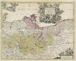
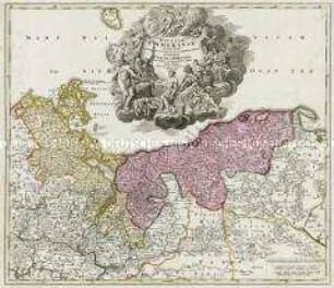
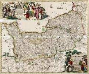
POMERANIAE/ DVCATVS TABVLA./ Auctore/ Eilhardo Lubino.
- Location
-
Deutsches Historisches Museum, Berlin
- Inventory number
-
Do 2002/85
- Measurements
-
Höhe x Breite: 43,1 x 53,3 cm (Blatt), Höhe x Breite: 38,1 x 49,1 cm (Platte)
- Material/Technique
-
Papier, Kupferstich, koloriert
- Classification
-
Kartografie (Gattung)
- Subject (what)
-
Pommern
- Event
-
Herstellung
- (who)
-
Kartograf: Eilhard Lübben
Verleger: Willem Janszoon Blaeu
Kupferstecher: Salomon Rogiers
- (where)
-
Amsterdam [historisch: Amstelodami], Niederlande
- (when)
-
um 1620
- Rights
-
Deutsches Historisches Museum
- Last update
- 24.03.2023, 9:29 AM CET
Data provider
This object is provided by:
Stiftung Deutsches Historisches Museum. If you have any questions about the object, please contact the data provider.
Stiftung Deutsches Historisches Museum. If you have any questions about the object, please contact the data provider.
Object type
- Regionalkarte
Associated
- Kartograf: Eilhard Lübben
- Verleger: Willem Janszoon Blaeu
- Kupferstecher: Salomon Rogiers
Time of origin
- um 1620
Other Objects (12)
Tabula Marchionatus Brandenburgici Et Ducatus Pomeraniae

Ducatus Pomeraniae
Ducatus Pomeraniae
Pomeraniae Ducatus Tabulam
Ducatus Pomeraniae Citerioris Et Ulterioris
Ducatus Silesiae Tabula Altera Superiorem Silesiam
Ducatus Silesia Tabula Altera Superiorem Silesiam
Nova et Accurata Normandiae Ducatus Tabula
Exactissima Statuum Totius Ducatus Bavariae Tabula
Tabula Ducatus Britanniae. Mit einer Nebenkarte: BREST
Ducatus Silesiae Tabula Geographica Prima, Inferiorem Eius Partem
Ducatus Stiriae Novissima Tabula. Mit einer Stadtansicht: Grätz
Tabula Marchionatus Brandenburgici Et Ducatus Pomeraniae
Ducatus Pomeraniae
Ducatus Pomeraniae
Pomeraniae Ducatus Tabulam
Ducatus Pomeraniae Citerioris Et Ulterioris
Ducatus Silesiae Tabula Altera Superiorem Silesiam
Ducatus Silesia Tabula Altera Superiorem Silesiam
Nova et Accurata Normandiae Ducatus Tabula
Exactissima Statuum Totius Ducatus Bavariae Tabula
Tabula Ducatus Britanniae. Mit einer Nebenkarte: BREST
Ducatus Silesiae Tabula Geographica Prima, Inferiorem Eius Partem