- Alternativer Titel
-
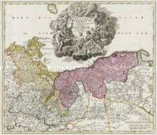
TABULA / MARCHIONATUS / BRANDENBURGICI / ET DUCATUS
- Standort
-
Deutsches Historisches Museum, Berlin
- Inventarnummer
-
Do 2006/502
- Maße
-
Höhe x Breite: 57 x 66,3 cm (Blatt)
Höhe x Breite: 40,7 x 51,5 cm (Karte)
Höhe x Breite: 43,7 x 56 cm (Platte)
- Material/Technik
-
Druckfarbe, Papier, Kupferstich, koloriert
- Klassifikation
-
Kartografie (Gattung)
- Bezug (was)
-
Brandenburg
Pommern
Obersächsischer Reichskreis
- Ereignis
-
Herstellung
- (wer)
-
Verleger, Kupferstecher, Geograph, Kartograf: Johann Baptist Homann
- (wo)
-
Nürnberg, Deutschland
- (wann)
-
um 1730
- Rechteinformation
-
Deutsches Historisches Museum
- Letzte Aktualisierung
- 24.03.2023, 09:28 MEZ
Datenpartner
Dieses Objekt wird bereitgestellt von:
Stiftung Deutsches Historisches Museum.
Bei Fragen zum Objekt wenden Sie sich bitte an den Datenpartner.
Objekttyp
- Regionalkarte
Beteiligte
- Verleger, Kupferstecher, Geograph, Kartograf: Johann Baptist Homann
Entstanden
- um 1730
Ähnliche Objekte (12)

Marchionatus Brandenburgici
Marchionatus Brandenburgici
Marchionatus Brandenburgici
Tabula Marchionatus Brandenburgici
Ducatus Pomeraniae
Ducatus Pomeraniae
Pomeraniae Ducatus Tabula
Pomeraniae Ducatus Tabulam
Ducatus Pomeraniae Citerioris Et Ulterioris
Brandenburgum Marchionatus
Brandeburgum Marchionatus
Totius Marchionatus Lusatiae
Marchionatus Brandenburgici
Marchionatus Brandenburgici
Marchionatus Brandenburgici
Tabula Marchionatus Brandenburgici
Ducatus Pomeraniae
Ducatus Pomeraniae
Pomeraniae Ducatus Tabula
Pomeraniae Ducatus Tabulam
Ducatus Pomeraniae Citerioris Et Ulterioris
Brandenburgum Marchionatus
Brandeburgum Marchionatus