Druck
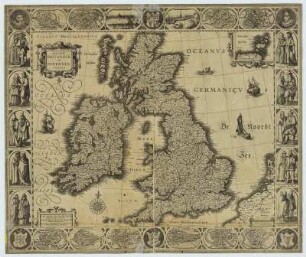
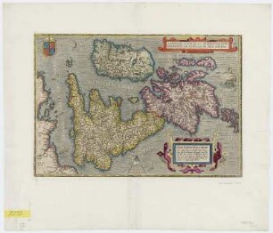
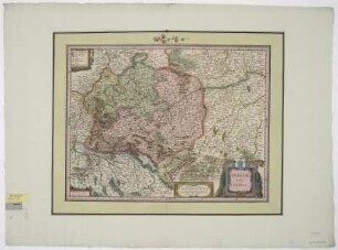
Karte der Britischen Inseln, [Ca. 1:3 275 000], Kupferstich, 1631
Magnae Britanniae et Hiberniae Tabula / Guiljelmus Blaeuw excudit. - [Ca. 1:3 275 000]. - Amstelodami : Blaeuw , [1631]. - 1 Kt. : Kupferst. - 48 x 36 cm. - Ab 1631 in den Blaeu-Atlanten nachgewiesen. - Koeman-Blaeu, Karte 5000:2.2, jedoch Rücks. ohne Text. - Mit e. Nebenkt.: Orcades Insulae. - Maßstab in graph. Form (Milliaria Anglica communia ; Miliaria Anglica parva)
in color
- Maße
-
36 x 47,5 cm; 1:3275000 (Maßstab)
- Standort
-
Sächsische Landesbibliothek - Staats- und Universitätsbibliothek Dresden (SLUB)
SLUB/Kartensammlung
- Inventarnummer
-
SLUB/KS A5516
- Weitere Nummer(n)
-
90033873 (Dokumentnummer)
df_dk_0012134 (Aufnahmenummer)
Bezug (was)
Schiffe
Grenzen
Insel
Druckgrafik
Grenzen
Insel
Druckgrafik
Bezug (wo)
Großbritannien (Dargestellter Ort)
Bezug (Ereignis)
Herstellung (Abgebildetes Objekt)
Klassifikation
Druckgrafik (Gattung)
Ereignis
Herstellung
(wann)
2012
(Beschreibung)
Aufnahme
- Letzte Aktualisierung
-
31.03.2023, 11:18 MESZ
Ähnliche Objekte (12)
![Karte der Britischen Inseln, [Ca. 1:3 275 000], Kupferstich, 1631](https://iiif.deutsche-digitale-bibliothek.de/image/2/65d2d273-f23e-417e-bbef-d44ffa088312/full/!306,450/0/default.jpg)
Karte der Britischen Inseln, [Ca. 1:3 275 000], Kupferstich, 1631
Karte der Britischen Inseln, 1:3 275 000, Kupferstich, ca. 1650
![Karte der Molukken, [Ca. 1:245 000], Kupferstich, 1630](https://iiif.deutsche-digitale-bibliothek.de/image/2/4b3c1bbb-e6e2-43c8-acc9-14e465d9a23f/full/!306,450/0/default.jpg)
Karte der Molukken, [Ca. 1:245 000], Kupferstich, 1630
![Karte der Molukken, [Ca. 1:245 000], Kupferstich, 1630](https://iiif.deutsche-digitale-bibliothek.de/image/2/5ea3783e-8ee3-4c1d-a566-62ed2b97a164/full/!306,450/0/default.jpg)
Karte der Molukken, [Ca. 1:245 000], Kupferstich, 1630
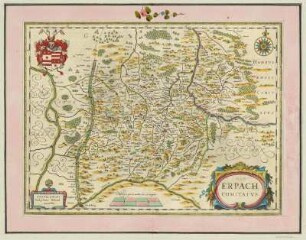
Karte der Grafschaft Erbach im Odenwald, Franken, 1:160 000, Kupferstich, 1635
Karte von Holstein, 1:570 000, Kupferstich, um 1631
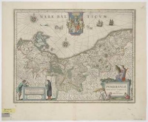
Karte von dem Herzogtum Pommern, 1:940 000, Kupferstich, um 1630
Karte der britischen Inseln, 1:3 500 000, Kupferstich, 1595
Bleauw, J.: Karte vom Kufürstentum Sachsen , ca. 1:800 000, Kupferstich, 1635
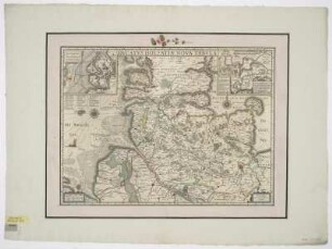
Karte der Grafschaft Nassau, 1:300 000, Kupferstich, um 1630
Karte des Gebietes um Nürnberg, Vogelschauplan von Nürnberg, 1:120 000, Kupferstich, um 1635
Karte von dem Schwäbischen Reichskreis, 1:880 000, Kupferstich, um 1635
Karte der Britischen Inseln, [Ca. 1:3 275 000], Kupferstich, 1631
Karte der Britischen Inseln, 1:3 275 000, Kupferstich, ca. 1650
Karte der Molukken, [Ca. 1:245 000], Kupferstich, 1630
Karte der Molukken, [Ca. 1:245 000], Kupferstich, 1630
Karte der Grafschaft Erbach im Odenwald, Franken, 1:160 000, Kupferstich, 1635
Karte von Holstein, 1:570 000, Kupferstich, um 1631
Karte von dem Herzogtum Pommern, 1:940 000, Kupferstich, um 1630
Karte der britischen Inseln, 1:3 500 000, Kupferstich, 1595
Bleauw, J.: Karte vom Kufürstentum Sachsen , ca. 1:800 000, Kupferstich, 1635
Karte der Grafschaft Nassau, 1:300 000, Kupferstich, um 1630
Karte des Gebietes um Nürnberg, Vogelschauplan von Nürnberg, 1:120 000, Kupferstich, um 1635