- Alternative title
-
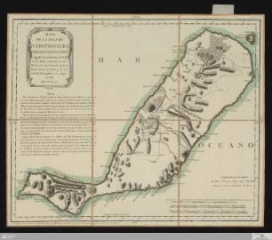
MAPA / DE LA ISLA DE / FUERTEVENTURA. / POR DON TOMÁS LOPEZ,
- Location
-
Deutsches Historisches Museum, Berlin
- Inventory number
-
Do 2006/215
- Measurements
-
Höhe x Breite: 46 x 60 cm (Blatt)
Höhe x Breite: 34,5 x 42,5 cm (Karte)
Höhe x Breite: 38,4 x 46 cm (Platte)
- Material/Technique
-
Druckfarbe, Papier, Kupferstich, grenzkoloriert
- Classification
-
Kartografie (Gattung)
- Subject (what)
-
Fuerteventura
Kanarische Inseln
Spanien
- Event
-
Herstellung
- (who)
-
Geograph: Tomás López de Vargas Machuca
- (where)
-
Madrid, Spanien
- (when)
-
1779
- Rights
-
Deutsches Historisches Museum
- Last update
-
24.03.2023, 9:27 AM CET
Data provider
This object is provided by:
Stiftung Deutsches Historisches Museum. If you have any questions about the object, please contact the data provider.
Stiftung Deutsches Historisches Museum. If you have any questions about the object, please contact the data provider.
Object type
- Regionalkarte
Associated
- Geograph: Tomás López de Vargas Machuca
Time of origin
- 1779
Other Objects (12)
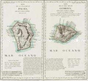
Mapa de la Isla de la Palma / Mapa de la Isla de la Gomera
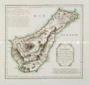
Mapa de la Isla de Tenerife

Mapa de la Isla de Lanzarote. Mit einer Nebenkarte: Mapa de la Isla del Hierro
Mapa de las Cercanias de Mexico
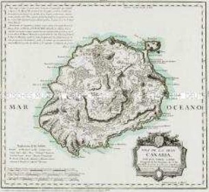
Isla de la Gran Canaria
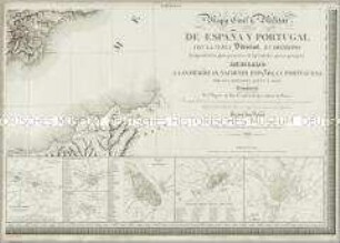
Mapa Civil y Militar de España y Portugal. Mit 23 Nebenkarten, einer Übersicht, zwei Profilen und einer Zusatzkarte
Mapa De La Isla De Fuerteventura
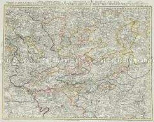
Grand Atlas . Bl. 40 (Wetterau, Oberrhein...): Contenante une partie de la Hesse et de Hesse Darmstadt, les Principautés de Nassau, de Hanau, une partie de l'Archêveché Electorale de Mayence et de l'Abbaye de Fuld, les Comtés et Principautés de Solms, de Stollberg, d'Ysemborg, de Goertz, de Runckel, et de plusieures Seigneuries et Territoires de quelques Villes de l'Empire etc.
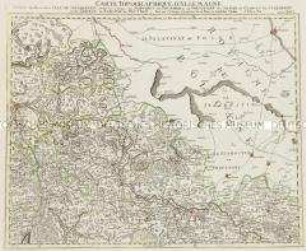
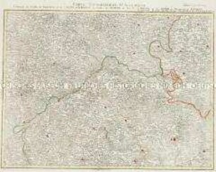
Grand Atlas . Bl. 26 (Niederschlesien): Contenant une Partie de la Silesie Inferieure, savoir les Cercles de Schwibus de Grunberg de Freystadt de Sagan de Glogau de Sternberg et de Guhrau le Baronie de Beuthen et et
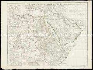
Carte de l'Egypte de la Nubie de l'Abissinie
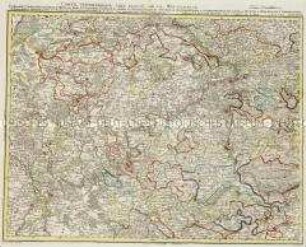
Grand Atlas . Bl. 39 (Wetterau...): Contenante l'Archevêché Electorale de Tréves, une Partie de l'Electorale Palatinat, les Comtès de Catzenelnbogen, de Sponheim, de Rheingraeffenstein, de Manderscheid Gerolstein, de Sayn, de Neuwith, de With Runckel, de Reifferscheidt, de Holtzapfel, le Rhingau, partie de l'Archevêché Electorale de Mayence, et de divers Pais partagés entre plusieurs Seigneurs et c (Verbessertes Blatt)
Grand Atlas . Bl. 53 (Czasslau, Böhmen, Mähren): Contenant les Cercles de Czasslau, et de Chrudin, de la Boheme, les Cercles de Olmütz, de Iglau, de Brunn et de Znaim du Margraviat de Maehren
Mapa de la Isla de la Palma / Mapa de la Isla de la Gomera
Mapa de la Isla de Tenerife
Mapa de la Isla de Lanzarote. Mit einer Nebenkarte: Mapa de la Isla del Hierro
Mapa de las Cercanias de Mexico
Isla de la Gran Canaria
Mapa Civil y Militar de España y Portugal. Mit 23 Nebenkarten, einer Übersicht, zwei Profilen und einer Zusatzkarte
Mapa De La Isla De Fuerteventura
Grand Atlas . Bl. 40 (Wetterau, Oberrhein...): Contenante une partie de la Hesse et de Hesse Darmstadt, les Principautés de Nassau, de Hanau, une partie de l'Archêveché Electorale de Mayence et de l'Abbaye de Fuld, les Comtés et Principautés de Solms, de Stollberg, d'Ysemborg, de Goertz, de Runckel, et de plusieures Seigneuries et Territoires de quelques Villes de l'Empire etc.
Grand Atlas . Bl. 26 (Niederschlesien): Contenant une Partie de la Silesie Inferieure, savoir les Cercles de Schwibus de Grunberg de Freystadt de Sagan de Glogau de Sternberg et de Guhrau le Baronie de Beuthen et et
Carte de l'Egypte de la Nubie de l'Abissinie
Grand Atlas . Bl. 39 (Wetterau...): Contenante l'Archevêché Electorale de Tréves, une Partie de l'Electorale Palatinat, les Comtès de Catzenelnbogen, de Sponheim, de Rheingraeffenstein, de Manderscheid Gerolstein, de Sayn, de Neuwith, de With Runckel, de Reifferscheidt, de Holtzapfel, le Rhingau, partie de l'Archevêché Electorale de Mayence, et de divers Pais partagés entre plusieurs Seigneurs et c (Verbessertes Blatt)