Karte / Plan
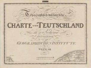
Topographisch-militärische Charte von Teutschland in 204 Sectionen, unternommen von dem Geographischen Institute zu Weimar 1807. Section 5. Teil von Holstein [West].
- Former reference number
-
C IX no. 28
- Dimensions
-
Maßstab: [1 : 185.000]
- Notes
-
Leicht beschädigt.
- Context
-
RW Karten >> 1. Topographische Karten >> 1.2. Kartenwerke und Spezialkarten >> 1.2.1. Deutschland und Europa
- Holding
-
RW Karten
- Date of creation
-
[1807]
- Other object pages
- Provenance
-
Diverse Registraturbildner
- Delivered via
- Last update
-
17.09.2025, 3:11 PM CEST
Data provider
This object is provided by:
Landesarchiv Nordrhein-Westfalen. Abteilung Rheinland. If you have any questions about the object, please contact the data provider.
Landesarchiv Nordrhein-Westfalen. Abteilung Rheinland. If you have any questions about the object, please contact the data provider.
Object type
- Karten / Pläne
Time of origin
- [1807]
Other Objects (12)

Topographisch-militairische Charte von Teutschland ; in 204 Sectionen unternommen von dem Geographischen Institute zu Weimar

Topographisch-militairische Charte von Teutschland, 4. Band ; in 204 Sectionen unternommen von dem Geographischen Institute zu Weimar
Topographisch-militairische Charte von Teutschland, 1. Band ; in 204 Sectionen unternommen von dem Geographischen Institute zu Weimar
Topographisch-militairische Charte von Teutschland, 3. Band ; in 204 Sectionen unternommen von dem Geographischen Institute zu Weimar
Topographisch-militairische Charte von Teutschland, 2. Band ; in 204 Sectionen unternommen von dem Geographischen Institute zu Weimar
Topographisch-militärische Charte von Teuschland in 204 Sectionen unternommen von dem Geographischen Institute zu Weimar.
![Topographisch-militärische Charte von Teutschland in 204 Sectionen, unternommen von dem Geographischen Institute zu Weimar 1807. Section 16. Teil von Frankreich [Unterelbe].](https://iiif.deutsche-digitale-bibliothek.de/image/2/d3588a84-2ff4-4f4a-ac05-330a11b3a0c2/full/!306,450/0/default.jpg)
Topographisch-militärische Charte von Teutschland in 204 Sectionen, unternommen von dem Geographischen Institute zu Weimar 1807. Section 16. Teil von Frankreich [Unterelbe].
![Topographisch-militärische Charte von Teutschland in 204 Sectionen, unternommen von dem Geographischen Institute zu Weimar 1807. Section 27. Teil von Frankreich [Lüneburg].](https://iiif.deutsche-digitale-bibliothek.de/image/2/fbb525cc-4c7b-4121-89cd-cb476ccdb1ff/full/!306,450/0/default.jpg)
Topographisch-militärische Charte von Teutschland in 204 Sectionen, unternommen von dem Geographischen Institute zu Weimar 1807. Section 27. Teil von Frankreich [Lüneburg].
![Topographisch-militärische Charte von Teutschland in 204 Sectionen, unternommen von dem Geographischen Institute zu Weimar 1807. Section 6. Teil von Holstein [Ost].](https://iiif.deutsche-digitale-bibliothek.de/image/2/23d0efff-f29e-407f-9901-3da048cbc6d0/full/!306,450/0/default.jpg)
Topographisch-militärische Charte von Teutschland in 204 Sectionen, unternommen von dem Geographischen Institute zu Weimar 1807. Section 6. Teil von Holstein [Ost].
![Topographisch-militärische Charte von Teutschland in 204 Sectionen, unternommen von dem Geographischen Institute zu Weimar 1807. Section 129. Teil von Schlesien [Jablunkau].](https://iiif.deutsche-digitale-bibliothek.de/image/2/0020311e-77e4-4dae-b9c3-47f9f0b1aa7c/full/!306,450/0/default.jpg)
Topographisch-militärische Charte von Teutschland in 204 Sectionen, unternommen von dem Geographischen Institute zu Weimar 1807. Section 129. Teil von Schlesien [Jablunkau].
![Topographisch-militärische Charte von Teutschland in 204 Sectionen, unternommen von dem Geographischen Institute zu Weimar 1807. Section 88. Teil von Schlesien [Breslau-Brieg].](https://iiif.deutsche-digitale-bibliothek.de/image/2/39a4728f-74e0-4be6-a443-bca9a3eca4ff/full/!306,450/0/default.jpg)
Topographisch-militärische Charte von Teutschland in 204 Sectionen, unternommen von dem Geographischen Institute zu Weimar 1807. Section 88. Teil von Schlesien [Breslau-Brieg].
![Topographisch-militärische Charte von Teutschland in 204 Sectionen, unternommen von dem Geographischen Institute zu Weimar 1807. Section 162. Teil von Österrich [Bruck-Hainburg].](https://iiif.deutsche-digitale-bibliothek.de/image/2/32eff850-6e2c-4496-ae6e-709e4831318e/full/!306,450/0/default.jpg)
Topographisch-militärische Charte von Teutschland in 204 Sectionen, unternommen von dem Geographischen Institute zu Weimar 1807. Section 162. Teil von Österrich [Bruck-Hainburg].
Topographisch-militairische Charte von Teutschland ; in 204 Sectionen unternommen von dem Geographischen Institute zu Weimar
Topographisch-militairische Charte von Teutschland, 4. Band ; in 204 Sectionen unternommen von dem Geographischen Institute zu Weimar
Topographisch-militairische Charte von Teutschland, 1. Band ; in 204 Sectionen unternommen von dem Geographischen Institute zu Weimar
Topographisch-militairische Charte von Teutschland, 3. Band ; in 204 Sectionen unternommen von dem Geographischen Institute zu Weimar
Topographisch-militairische Charte von Teutschland, 2. Band ; in 204 Sectionen unternommen von dem Geographischen Institute zu Weimar
Topographisch-militärische Charte von Teuschland in 204 Sectionen unternommen von dem Geographischen Institute zu Weimar.
Topographisch-militärische Charte von Teutschland in 204 Sectionen, unternommen von dem Geographischen Institute zu Weimar 1807. Section 16. Teil von Frankreich [Unterelbe].
Topographisch-militärische Charte von Teutschland in 204 Sectionen, unternommen von dem Geographischen Institute zu Weimar 1807. Section 27. Teil von Frankreich [Lüneburg].
Topographisch-militärische Charte von Teutschland in 204 Sectionen, unternommen von dem Geographischen Institute zu Weimar 1807. Section 6. Teil von Holstein [Ost].
Topographisch-militärische Charte von Teutschland in 204 Sectionen, unternommen von dem Geographischen Institute zu Weimar 1807. Section 129. Teil von Schlesien [Jablunkau].
Topographisch-militärische Charte von Teutschland in 204 Sectionen, unternommen von dem Geographischen Institute zu Weimar 1807. Section 88. Teil von Schlesien [Breslau-Brieg].