Altkarte | Landkarte | Politik-, Rechts- und Verwaltungskarte | Thematische Karte | Topographische Karte
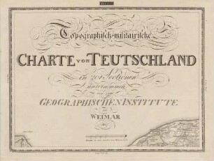
Topographisch-militairische Charte von Teutschland ; in 204 Sectionen unternommen von dem Geographischen Institute zu Weimar
Kurzbeschreibung: Kartenwerk
Kartographische Angaben: Graphischer Maßstab in deutschen, geographischen Meilen
Erweiterte Beschreibung: in 5 Bänden Titel Section 10 (1. Band) Paralleltitel Section 10 [b] (1. Band) Widmung Section 4 (3. Band) Band 5: Supplement oder Erweiterung nach Westen der Geographisch-militairischen Charte von Teutschland
- Standort
-
Greifswald
- Sammlung
-
Kartensammlung des Instituts für Geographie und Geologie (Universität Greifswald)
- Inventarnummer
-
AltKW/C20.01/0003
- Maße
-
Maßstab [ca. 1:180.000]
- Material/Technik
-
Büttenpapier; Kupferstich
- Verwandtes Objekt und Literatur
-
hat Teil: General-Charte von Teutschland in vier Blättern
hat Teil: Topographisch-militairische Charte von Teutschland, 4. Band
hat Teil: Topographisch-militairische Charte von Teutschland, 2. Band
hat Teil: Supplement oder Erweiterung nach Westen der Topographisch-militairischen Charte von Teutschland in 204 Sectionen
hat Teil: Topographisch-militairische Charte von Teutschland, 1. Band
hat Teil: Topographisch-militairische Charte von Teutschland, 3. Band
- Klassifikation
-
Kartographie
- Bezug (wo)
-
Weimar
- Ereignis
-
Herstellung
- (wann)
-
1807 - 1813
- Letzte Aktualisierung
- 25.03.2025, 08:45 UTC
Datenpartner
Dieses Objekt wird bereitgestellt von:
Universität Greifswald. Kartensammlung des Instituts für Geographie und Geologie. Bei Fragen zum Objekt wenden Sie sich bitte an den Datenpartner.
Universität Greifswald. Kartensammlung des Instituts für Geographie und Geologie. Bei Fragen zum Objekt wenden Sie sich bitte an den Datenpartner.
Objekttyp
- Altkarte; Thematische Karte; Landkarte; Topographische Karte; Politik-, Rechts- und Verwaltungskarte
Entstanden
- 1807 - 1813
Ähnliche Objekte (12)

Topographisch-militairische Charte von Teutschland, 4. Band ; in 204 Sectionen unternommen von dem Geographischen Institute zu Weimar
Topographisch-militairische Charte von Teutschland, 1. Band ; in 204 Sectionen unternommen von dem Geographischen Institute zu Weimar
Topographisch-militairische Charte von Teutschland, 2. Band ; in 204 Sectionen unternommen von dem Geographischen Institute zu Weimar
Topographisch-militairische Charte von Teutschland, 3. Band ; in 204 Sectionen unternommen von dem Geographischen Institute zu Weimar

Topographisch-militairische Charte von Teutschland : in 204 Sectionen ; Snr. Hochfürstl. Durchlaucht dem souverainen Herzoge Carl August zu Sachsen-Weimar und Eisenach / unternommen von dem Geographischen Institute zu Weimar
![Topographisch-militairische Charte von Teutschland in 204 Sectionen. [gewidmet] Herzog Carl August zu Sachsen-Weimar und Eisenach = Carte Topographique Et Militaire De L'Allemagne / unternommen von dem Geographischen Institute zu Weimar.](https://iiif.deutsche-digitale-bibliothek.de/image/2/e4e23661-b5ca-4eeb-bb71-1fd50ae0c8c6/full/!306,450/0/default.jpg)
Topographisch-militairische Charte von Teutschland in 204 Sectionen. [gewidmet] Herzog Carl August zu Sachsen-Weimar und Eisenach = Carte Topographique Et Militaire De L'Allemagne / unternommen von dem Geographischen Institute zu Weimar.
![Topographisch-militärische Charte von Teutschland in 204 Sectionen, unternommen von dem Geographischen Institute zu Weimar 1807. Section 6. Teil von Holstein [Ost].](https://iiif.deutsche-digitale-bibliothek.de/image/2/17d813a7-5e6f-4ed8-bf96-d561c50425b4/full/!306,450/0/default.jpg)
Topographisch-militärische Charte von Teutschland in 204 Sectionen, unternommen von dem Geographischen Institute zu Weimar 1807. Section 6. Teil von Holstein [Ost].
![Topographisch-militärische Charte von Teutschland in 204 Sectionen, unternommen von dem Geographischen Institute zu Weimar 1807. Section 129. Teil von Schlesien [Jablunkau].](https://iiif.deutsche-digitale-bibliothek.de/image/2/5a47e787-1bff-4019-9420-3b41909fc326/full/!306,450/0/default.jpg)
Topographisch-militärische Charte von Teutschland in 204 Sectionen, unternommen von dem Geographischen Institute zu Weimar 1807. Section 129. Teil von Schlesien [Jablunkau].
![Topographisch-militärische Charte von Teutschland in 204 Sectionen, unternommen von dem Geographischen Institute zu Weimar 1807. Section 16. Teil von Frankreich [Unterelbe].](https://iiif.deutsche-digitale-bibliothek.de/image/2/484c86bd-eb17-4231-9571-be6d186c94a6/full/!306,450/0/default.jpg)
Topographisch-militärische Charte von Teutschland in 204 Sectionen, unternommen von dem Geographischen Institute zu Weimar 1807. Section 16. Teil von Frankreich [Unterelbe].
![Topographisch-militärische Charte von Teutschland in 204 Sectionen, unternommen von dem Geographischen Institute zu Weimar 1807. Section 27. Teil von Frankreich [Lüneburg].](https://iiif.deutsche-digitale-bibliothek.de/image/2/91518fcc-a75e-43d3-b1b0-a1e290ca9ae1/full/!306,450/0/default.jpg)
Topographisch-militärische Charte von Teutschland in 204 Sectionen, unternommen von dem Geographischen Institute zu Weimar 1807. Section 27. Teil von Frankreich [Lüneburg].
![Topographisch-militärische Charte von Teutschland in 204 Sectionen, unternommen von dem Geographischen Institute zu Weimar 1807. Section 5. Teil von Holstein [West].](https://iiif.deutsche-digitale-bibliothek.de/image/2/80ee863a-abe8-47f4-9308-972218ad14fa/full/!306,450/0/default.jpg)
Topographisch-militärische Charte von Teutschland in 204 Sectionen, unternommen von dem Geographischen Institute zu Weimar 1807. Section 5. Teil von Holstein [West].

Topographisch-militärische Charte von Teuschland in 204 Sectionen unternommen von dem Geographischen Institute zu Weimar.
Topographisch-militairische Charte von Teutschland, 4. Band ; in 204 Sectionen unternommen von dem Geographischen Institute zu Weimar
Topographisch-militairische Charte von Teutschland, 1. Band ; in 204 Sectionen unternommen von dem Geographischen Institute zu Weimar
Topographisch-militairische Charte von Teutschland, 2. Band ; in 204 Sectionen unternommen von dem Geographischen Institute zu Weimar
Topographisch-militairische Charte von Teutschland, 3. Band ; in 204 Sectionen unternommen von dem Geographischen Institute zu Weimar
Topographisch-militairische Charte von Teutschland : in 204 Sectionen ; Snr. Hochfürstl. Durchlaucht dem souverainen Herzoge Carl August zu Sachsen-Weimar und Eisenach / unternommen von dem Geographischen Institute zu Weimar
Topographisch-militairische Charte von Teutschland in 204 Sectionen. [gewidmet] Herzog Carl August zu Sachsen-Weimar und Eisenach = Carte Topographique Et Militaire De L'Allemagne / unternommen von dem Geographischen Institute zu Weimar.
Topographisch-militärische Charte von Teutschland in 204 Sectionen, unternommen von dem Geographischen Institute zu Weimar 1807. Section 6. Teil von Holstein [Ost].
Topographisch-militärische Charte von Teutschland in 204 Sectionen, unternommen von dem Geographischen Institute zu Weimar 1807. Section 129. Teil von Schlesien [Jablunkau].
Topographisch-militärische Charte von Teutschland in 204 Sectionen, unternommen von dem Geographischen Institute zu Weimar 1807. Section 16. Teil von Frankreich [Unterelbe].
Topographisch-militärische Charte von Teutschland in 204 Sectionen, unternommen von dem Geographischen Institute zu Weimar 1807. Section 27. Teil von Frankreich [Lüneburg].
Topographisch-militärische Charte von Teutschland in 204 Sectionen, unternommen von dem Geographischen Institute zu Weimar 1807. Section 5. Teil von Holstein [West].