Karte / Plan
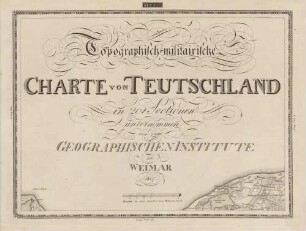
Topographisch-militärische Charte von Teutschland in 204 Sectionen, unternommen von dem Geographischen Institute zu Weimar 1807. Section 27. Teil von Frankreich [Lüneburg].
- Former reference number
-
C IX no. 28
- Dimensions
-
Maßstab: [1 : 185.000]
- Context
-
RW Karten >> 1. Topographische Karten >> 1.2. Kartenwerke und Spezialkarten >> 1.2.1. Deutschland und Europa
- Holding
-
RW Karten
- Date of creation
-
[1807]
- Other object pages
- Provenance
-
Diverse Registraturbildner
- Delivered via
- Last update
-
05.11.2025, 3:35 PM CET
Data provider
This object is provided by:
Landesarchiv Nordrhein-Westfalen. Abteilung Rheinland. If you have any questions about the object, please contact the data provider.
Landesarchiv Nordrhein-Westfalen. Abteilung Rheinland. If you have any questions about the object, please contact the data provider.
Object type
- Karten / Pläne
Time of origin
- [1807]
Other Objects (12)

Topographisch-militairische Charte von Teutschland ; in 204 Sectionen unternommen von dem Geographischen Institute zu Weimar

Topographisch-militairische Charte von Teutschland, 4. Band ; in 204 Sectionen unternommen von dem Geographischen Institute zu Weimar
Topographisch-militairische Charte von Teutschland, 1. Band ; in 204 Sectionen unternommen von dem Geographischen Institute zu Weimar
Topographisch-militairische Charte von Teutschland, 3. Band ; in 204 Sectionen unternommen von dem Geographischen Institute zu Weimar
Topographisch-militairische Charte von Teutschland, 2. Band ; in 204 Sectionen unternommen von dem Geographischen Institute zu Weimar
Topographisch-militärische Charte von Teuschland in 204 Sectionen unternommen von dem Geographischen Institute zu Weimar.
![Topographisch-militärische Charte von Teutschland in 204 Sectionen, unternommen von dem Geographischen Institute zu Weimar 1807. Section 16. Teil von Frankreich [Unterelbe].](https://iiif.deutsche-digitale-bibliothek.de/image/2/484c86bd-eb17-4231-9571-be6d186c94a6/full/!306,450/0/default.jpg)
Topographisch-militärische Charte von Teutschland in 204 Sectionen, unternommen von dem Geographischen Institute zu Weimar 1807. Section 16. Teil von Frankreich [Unterelbe].
![Topographisch-militärische Charte von Teutschland in 204 Sectionen, unternommen von dem Geographischen Institute zu Weimar 1807. Section 5. Teil von Holstein [West].](https://iiif.deutsche-digitale-bibliothek.de/image/2/80ee863a-abe8-47f4-9308-972218ad14fa/full/!306,450/0/default.jpg)
Topographisch-militärische Charte von Teutschland in 204 Sectionen, unternommen von dem Geographischen Institute zu Weimar 1807. Section 5. Teil von Holstein [West].
![Topographisch-militärische Charte von Teutschland in 204 Sectionen, unternommen von dem Geographischen Institute zu Weimar 1807. Section 6. Teil von Holstein [Ost].](https://iiif.deutsche-digitale-bibliothek.de/image/2/17d813a7-5e6f-4ed8-bf96-d561c50425b4/full/!306,450/0/default.jpg)
Topographisch-militärische Charte von Teutschland in 204 Sectionen, unternommen von dem Geographischen Institute zu Weimar 1807. Section 6. Teil von Holstein [Ost].
![Topographisch-militärische Charte von Teutschland in 204 Sectionen, unternommen von dem Geographischen Institute zu Weimar 1807. Section 129. Teil von Schlesien [Jablunkau].](https://iiif.deutsche-digitale-bibliothek.de/image/2/5a47e787-1bff-4019-9420-3b41909fc326/full/!306,450/0/default.jpg)
Topographisch-militärische Charte von Teutschland in 204 Sectionen, unternommen von dem Geographischen Institute zu Weimar 1807. Section 129. Teil von Schlesien [Jablunkau].
![Topographisch-militärische Charte von Teutschland in 204 Sectionen, unternommen von dem Geographischen Institute zu Weimar 1807. Section 70. Teil von Sachsen [Halle-Leipzig].](https://iiif.deutsche-digitale-bibliothek.de/image/2/ad046c44-1953-46c9-b225-75a236166260/full/!306,450/0/default.jpg)
Topographisch-militärische Charte von Teutschland in 204 Sectionen, unternommen von dem Geographischen Institute zu Weimar 1807. Section 70. Teil von Sachsen [Halle-Leipzig].
![Topographisch-militärische Charte von Teutschland in 204 Sectionen, unternommen von dem Geographischen Institute zu Weimar 1807. Section 17. Teil von Frankreich [Hamburg-Segeberg].](https://iiif.deutsche-digitale-bibliothek.de/image/2/727e61f0-8cc3-4ef3-a1c7-8e956b3510b1/full/!306,450/0/default.jpg)
Topographisch-militärische Charte von Teutschland in 204 Sectionen, unternommen von dem Geographischen Institute zu Weimar 1807. Section 17. Teil von Frankreich [Hamburg-Segeberg].
Topographisch-militairische Charte von Teutschland ; in 204 Sectionen unternommen von dem Geographischen Institute zu Weimar
Topographisch-militairische Charte von Teutschland, 4. Band ; in 204 Sectionen unternommen von dem Geographischen Institute zu Weimar
Topographisch-militairische Charte von Teutschland, 1. Band ; in 204 Sectionen unternommen von dem Geographischen Institute zu Weimar
Topographisch-militairische Charte von Teutschland, 3. Band ; in 204 Sectionen unternommen von dem Geographischen Institute zu Weimar
Topographisch-militairische Charte von Teutschland, 2. Band ; in 204 Sectionen unternommen von dem Geographischen Institute zu Weimar
Topographisch-militärische Charte von Teuschland in 204 Sectionen unternommen von dem Geographischen Institute zu Weimar.
Topographisch-militärische Charte von Teutschland in 204 Sectionen, unternommen von dem Geographischen Institute zu Weimar 1807. Section 16. Teil von Frankreich [Unterelbe].
Topographisch-militärische Charte von Teutschland in 204 Sectionen, unternommen von dem Geographischen Institute zu Weimar 1807. Section 5. Teil von Holstein [West].
Topographisch-militärische Charte von Teutschland in 204 Sectionen, unternommen von dem Geographischen Institute zu Weimar 1807. Section 6. Teil von Holstein [Ost].
Topographisch-militärische Charte von Teutschland in 204 Sectionen, unternommen von dem Geographischen Institute zu Weimar 1807. Section 129. Teil von Schlesien [Jablunkau].
Topographisch-militärische Charte von Teutschland in 204 Sectionen, unternommen von dem Geographischen Institute zu Weimar 1807. Section 70. Teil von Sachsen [Halle-Leipzig].