Fotografie
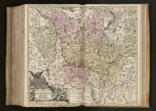
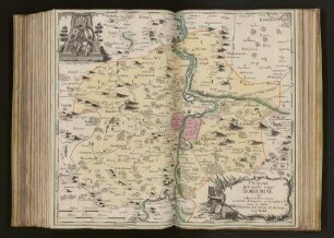
Mappa Geographica Circuli Metalliferi : Mappa Geographica Circuli Metalliferi. Kupferstich, handkoloriert; 101 x 59 cm (um 1750/1760; M. Seutter, T. C. Lotter). Dresden: SLUB Tab.geogr.B.Sax.F.240 (A 14050)
Mappa Geographica Circuli Metalliferi. Kupferstich, handkoloriert; 101 x 59 cm (um 1750/1760; M. Seutter, T. C. Lotter). Dresden: SLUB Tab.geogr.B.Sax.F.240 (A 14050)
Negativ in schwarzweiß
- Location
-
Sächsischer Kunstverein Dresden
- Inventory number
-
Tab.geogr.B.Sax.F.240 (A 14050)
- Other number(s)
-
df_hauptkatalog_0272854 (Aufnahmenummer)
72050300 (Dokumentennummer)
- Measurements
-
101 x 59 cm (Werk/Vorlage)
- Classification
-
Fotografie (Gattung)
- Subject (what)
-
Druckgrafik
Landkarte
Bergbau
Bergbauanlage
- Subject (event)
-
Herstellung
- (who)
-
Seutter, Matthäus (Stecher)
Lotter, Tobias Conrad (Hersteller)
- (when)
-
um 1750/1760
- (description)
-
Erschaffung abgebildetes Objekt
Kupferstich & handkoloriert (Material/Technik)
- Event
-
Fotografische Aufnahme
- (who)
-
Richter, Regine (Fotograf)
- (when)
-
1995
- Rights
-
Bitte beachten Sie die Nutzungsbedingungen der Deutschen Fotothek.
- Last update
-
05.03.2025, 4:26 PM CET
Data provider
This object is provided by:
Deutsche Fotothek. If you have any questions about the object, please contact the data provider.
Deutsche Fotothek. If you have any questions about the object, please contact the data provider.
Object type
- Fotografie
Associated
- Richter, Regine (Fotograf)
- Seutter, Matthäus (Stecher)
- Lotter, Tobias Conrad (Hersteller)
Time of origin
- 1995
- um 1750/1760
Other Objects (12)
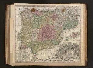
Novissima et accuratissima Regnorum Hispaniae et Portugalliae Mappa Geographica
Electoratus sive Marchia Brandenburgensis, juxta novissimam Delineationem in mappa Geographica
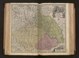
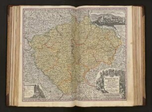
Mappa Geographica Regnum Bohemiae : Cum Adiunctis Ducatu Silesiae, Et Marchionatibus Moraviae Et Lusatiae repraesentans

Spatiosissimum Imperium Russiae magnae iuxta recentißimas Observationes Mappa Geographica
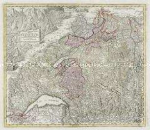
Mappa geographica illustris Helvetiorum Reipublicae Bernensis
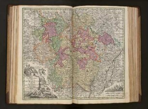
Bohemia Regnum : juxta XII. Circulos divisum, cum Comitatu Glacensi et ditione Egrana, nec non confinibus Provinciis in mappa Geographica
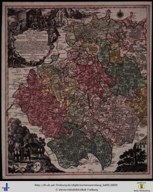
Mappa geographica circuli Metalliferi Electoratus Saxoniae
Mappa Geographica, in qua Ducatus Lotharingiae Et Barr ut et Episcopatuum Metens. Tullens. Verdunens. Territoria, Tractusque Finitimi in suos quique ditiones disterminati sistuntur
![S[acri] R[omani] I[mperii] Principat[us] et Archiepiscopatus Salisburgensis mappa Geographica : delineatus in qua Subjectæ appertinent[ur] finitimae Regiones et Ditiones accuratiss[imae] ab oculos ponuntur](https://iiif.deutsche-digitale-bibliothek.de/image/2/b8e0a5f7-4875-4c80-abde-a61951301751/full/!306,450/0/default.jpg)
S[acri] R[omani] I[mperii] Principat[us] et Archiepiscopatus Salisburgensis mappa Geographica : delineatus in qua Subjectæ appertinent[ur] finitimae Regiones et Ditiones accuratiss[imae] ab oculos ponuntur
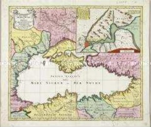
Nova Mappa Maris Nigri et Freti Constantinopolitani. Mit einer Nebenkarte
Pragae Metropolis regni Bohemiae cum adjacentibus terris accurata descriptio geographica

Episcopatus Numburgensis Et Cizensis Delineatio geographica : adjectis præfecturis Portensi, Pegaviensi, Tautenburg: et finitimis
Novissima et accuratissima Regnorum Hispaniae et Portugalliae Mappa Geographica
Electoratus sive Marchia Brandenburgensis, juxta novissimam Delineationem in mappa Geographica
Mappa Geographica Regnum Bohemiae : Cum Adiunctis Ducatu Silesiae, Et Marchionatibus Moraviae Et Lusatiae repraesentans
Spatiosissimum Imperium Russiae magnae iuxta recentißimas Observationes Mappa Geographica
Mappa geographica illustris Helvetiorum Reipublicae Bernensis
Bohemia Regnum : juxta XII. Circulos divisum, cum Comitatu Glacensi et ditione Egrana, nec non confinibus Provinciis in mappa Geographica
Mappa geographica circuli Metalliferi Electoratus Saxoniae
Mappa Geographica, in qua Ducatus Lotharingiae Et Barr ut et Episcopatuum Metens. Tullens. Verdunens. Territoria, Tractusque Finitimi in suos quique ditiones disterminati sistuntur
S[acri] R[omani] I[mperii] Principat[us] et Archiepiscopatus Salisburgensis mappa Geographica : delineatus in qua Subjectæ appertinent[ur] finitimae Regiones et Ditiones accuratiss[imae] ab oculos ponuntur
Nova Mappa Maris Nigri et Freti Constantinopolitani. Mit einer Nebenkarte
Pragae Metropolis regni Bohemiae cum adjacentibus terris accurata descriptio geographica