Regionalkarte
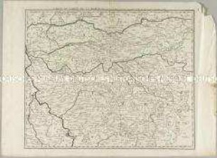
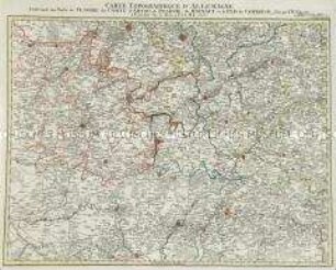
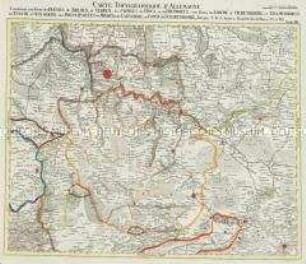
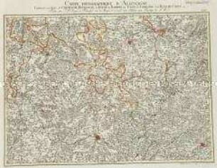
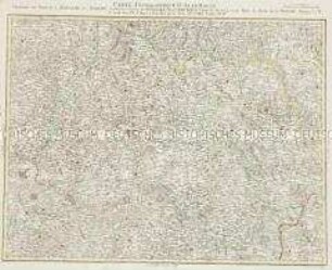
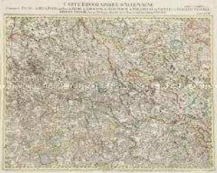
Grand Atlas . Bl. 77 (Grison, Tirol, Pludentz., Bormio): Contenant une Partie des Grisons, du Comté de Tyrol, du Comté de Pludentz, et le Comté de Bormio,
- Alternative title
-
CARTE TOPOGRAPHIQUE D'ALLEMAGNE / Contenant une Partie des GRISONS, du COMTÉ de TYROL, du COMTÉ de PLUDENTZ, et le COMTÉ de BORMIO,
- Location
-
Deutsches Historisches Museum, Berlin
- Inventory number
-
Do 2006/1059.77
- Measurements
-
Höhe x Breite: 56,5 x 78 cm, Höhe: 56,5 cm, Breite: 78 cm, Tiefe: 3 cm (Atlas)
Höhe x Breite: 56,5 x 78 cm (Blatt)
Höhe x Breite: 52 x 68 cm (Platte)
Höhe x Breite: 46 x 59 cm (Karte)
- Material/Technique
-
Papier, Kupferstich, koloriert, gebunden |Fadenheftung
- Classification
-
Kartografie (Gattung)
- Subject (what)
-
Deutschland
- Event
-
Herstellung
- (who)
-
Verleger, Militärkartograph: Johann Wilhelm Abraham Jaeger
Stecher: Johann Gottlieb Facius
- (where)
-
Frankfurt (Main) [historisch: Frankfurt, Reichsstadt], Deutschland
- (when)
-
um 1789
- Rights
-
Deutsches Historisches Museum
- Last update
-
24.03.2023, 9:27 AM CET
Data provider
This object is provided by:
Stiftung Deutsches Historisches Museum. If you have any questions about the object, please contact the data provider.
Stiftung Deutsches Historisches Museum. If you have any questions about the object, please contact the data provider.
Object type
- Regionalkarte
Associated
- Verleger, Militärkartograph: Johann Wilhelm Abraham Jaeger
- Stecher: Johann Gottlieb Facius
Time of origin
- um 1789
Other Objects (12)
Carte du Comté de la Marck

La Comtè de Glatz
Grand Atlas . Bl. 74 (Burgund, Freigrafschaft): Contenante une Partie du Duché de Bourgogne et de Franche Comté.
Duchés de Bergue et Juliers Electorat de Cologne Gueldre et Comté de Meurs
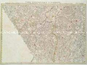
Grand Atlas . Bl. 78 (Tirol, Kärnten, Brixen): Contenant une Partie du Comte de Tirol et du Duche de Carinthie Superieure et l'Eveche de Brixen
Grand Atlas . Bl. 37 (Flandern...): Contenant une Partie de Flandre, du Comté d'Artois, de Picardie du Haynaut, et le Pais de Cambresis et et
Grand Atlas . Bl. 13 (Bremen, Oldenburg, Delmenhorst, Schauenburg) : Contenant une Partie des Duchés de Bremen, et Verden, les Comtés de Hoya, et de Diepholtz, une Partie du Duché d'Oldenbourg, et Delmenhorst, de l'Eveché d'Osnabruk, des Principautés de Minden, et de Calenberg, du Comté de Schauenbourg et et
Grand Atlas . Bl. 65 (Champagne, Burgund, Bar,Lothringen): Contenante une Partie de Champagne, Bourgogne, du Duché de Barrois, des Etats de Lorraine et de Franche Comté et.
Grand Atlas . Bl. 44 (Böhmen, Schlesien): Contenant une Partie de la Royaume du Boheme Scavoir les Cercles de Königgraetz, et Chrudim, le Comte de Glatz, et une Partie du Duchè de la Silesie
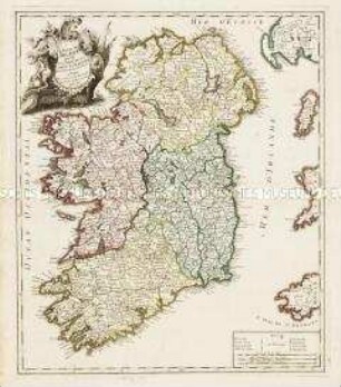
Le Royaume d'Irlande divisé en Provinces, Comtés et Baronies
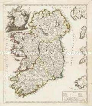
Le Royaume d'Irlande divisé en Provinces, Comtés et Baronies
Grand Atlas . Bl. 48 (Frankreich, Pfalz, Falkenstein, Leiningen, Bitsch): Contenant le Duché de Deux Ponts, une Partie du Duché de Lorraine, de l'Electorat de Palatinat, les Comtés de Falckenstein, Leiningen, Bitsche et et (Verbessertes Blatt)
Carte du Comté de la Marck
La Comtè de Glatz
Grand Atlas . Bl. 74 (Burgund, Freigrafschaft): Contenante une Partie du Duché de Bourgogne et de Franche Comté.
Duchés de Bergue et Juliers Electorat de Cologne Gueldre et Comté de Meurs
Grand Atlas . Bl. 78 (Tirol, Kärnten, Brixen): Contenant une Partie du Comte de Tirol et du Duche de Carinthie Superieure et l'Eveche de Brixen
Grand Atlas . Bl. 37 (Flandern...): Contenant une Partie de Flandre, du Comté d'Artois, de Picardie du Haynaut, et le Pais de Cambresis et et
Grand Atlas . Bl. 13 (Bremen, Oldenburg, Delmenhorst, Schauenburg) : Contenant une Partie des Duchés de Bremen, et Verden, les Comtés de Hoya, et de Diepholtz, une Partie du Duché d'Oldenbourg, et Delmenhorst, de l'Eveché d'Osnabruk, des Principautés de Minden, et de Calenberg, du Comté de Schauenbourg et et
Grand Atlas . Bl. 65 (Champagne, Burgund, Bar,Lothringen): Contenante une Partie de Champagne, Bourgogne, du Duché de Barrois, des Etats de Lorraine et de Franche Comté et.
Grand Atlas . Bl. 44 (Böhmen, Schlesien): Contenant une Partie de la Royaume du Boheme Scavoir les Cercles de Königgraetz, et Chrudim, le Comte de Glatz, et une Partie du Duchè de la Silesie
Le Royaume d'Irlande divisé en Provinces, Comtés et Baronies
Le Royaume d'Irlande divisé en Provinces, Comtés et Baronies