Regionalkarte
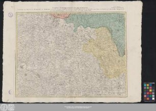
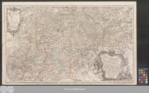
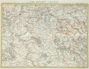
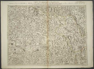
Grand Atlas . Bl. 44 (Böhmen, Schlesien): Contenant une Partie de la Royaume du Boheme Scavoir les Cercles de Königgraetz, et Chrudim, le Comte de Glatz, et une Partie du Duchè de la Silesie
- Alternative title
-
CARTE TOPOGRAPHIQUE D'ALLEMAGNE / Contenant une Partie de la ROYAUME du BOHEME Scavoir les Cercles de KÖNIGGRAETZ, et CHRUDIM, le Comte de GLATZ, et une Partie du Duchè de la SILESIE
- Location
-
Deutsches Historisches Museum, Berlin
- Inventory number
-
Do 2006/1059.44
- Measurements
-
Höhe x Breite: 56,5 x 78 cm, Höhe: 56,5 cm, Breite: 78 cm, Tiefe: 3 cm (Atlas)
Höhe x Breite: 56,5 x 78 cm (Blatt)
Höhe x Breite: 52 x 68 cm (Platte)
Höhe x Breite: 46 x 59 cm (Karte)
- Material/Technique
-
Papier, Kupferstich, koloriert, gebunden |Fadenheftung
- Classification
-
Kartografie (Gattung)
- Subject (what)
-
Deutschland
- Event
-
Herstellung
- (who)
-
Verleger, Militärkartograph: Johann Wilhelm Abraham Jaeger
Stecher: Daniel Adam Hauer
- (where)
-
Frankfurt (Main) [historisch: Frankfurt, Reichsstadt], Deutschland
- (when)
-
um 1787
- Rights
-
Deutsches Historisches Museum
- Last update
- 24.03.2023, 9:31 AM CET
Data provider
This object is provided by:
Stiftung Deutsches Historisches Museum. If you have any questions about the object, please contact the data provider.
Stiftung Deutsches Historisches Museum. If you have any questions about the object, please contact the data provider.
Object type
- Regionalkarte
Associated
- Verleger, Militärkartograph: Johann Wilhelm Abraham Jaeger
- Stecher: Daniel Adam Hauer
Time of origin
- um 1787
Other Objects (12)
Feuille XLIV: Carte Topographique D'Allemagne Contenant une Partie de la Royaume du Boheme Scavoir les Cercles de Königgrætz, et Chrudim, le Comte de Glatz, et une Partie du Duchè de la Silesie
Partie Méridionale Du Langraviat De Hesse-Cassel avec une Partie de la Vetteravie

Une Partie du Grand Bassin du Château de Benrath 1775
Grand Atlas . Bl. 64 (Frankreich, Champagne, Burgund, Orleans): Contenante une Partie de La France, scavoir une Partie de la Champagne, Bourgogne, d'Orleans etc.
Carte Topographique D'Allemagne Contenant une Partie du Royaume de Boheme Scavoir les Cercles de Königgraetz, et Chrudim, le Comte de Glatz, et une Partie du Duchè de la Silesie : A. P. d. S. M. I.

Une Partie de l'Enge
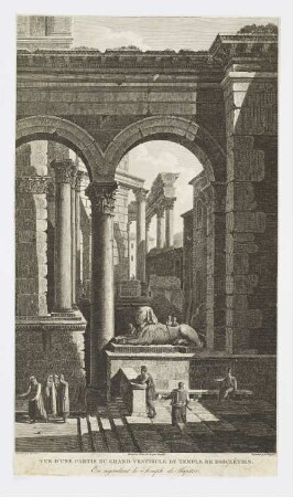
Vue d’une partie du grand vestibule du temple de Dioclétien
Vue d'une partie du camp retranché de Dong-Song
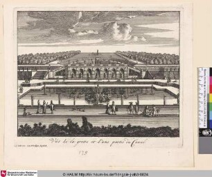
Vue de la grotte et d'une partie du Canal

Vue du Chateau et d'une partie de la ville de Versailles

Carte d'une partie du Royaume de Bohême, et de la Moravie

Plan d'une partie de Magdebourg ...
Feuille XLIV: Carte Topographique D'Allemagne Contenant une Partie de la Royaume du Boheme Scavoir les Cercles de Königgrætz, et Chrudim, le Comte de Glatz, et une Partie du Duchè de la Silesie
Partie Méridionale Du Langraviat De Hesse-Cassel avec une Partie de la Vetteravie
Une Partie du Grand Bassin du Château de Benrath 1775
Grand Atlas . Bl. 64 (Frankreich, Champagne, Burgund, Orleans): Contenante une Partie de La France, scavoir une Partie de la Champagne, Bourgogne, d'Orleans etc.
Carte Topographique D'Allemagne Contenant une Partie du Royaume de Boheme Scavoir les Cercles de Königgraetz, et Chrudim, le Comte de Glatz, et une Partie du Duchè de la Silesie : A. P. d. S. M. I.
Une Partie de l'Enge
Vue d’une partie du grand vestibule du temple de Dioclétien
Vue d'une partie du camp retranché de Dong-Song
Vue de la grotte et d'une partie du Canal
Vue du Chateau et d'une partie de la ville de Versailles
Carte d'une partie du Royaume de Bohême, et de la Moravie