- Reference number
-
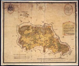
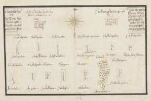
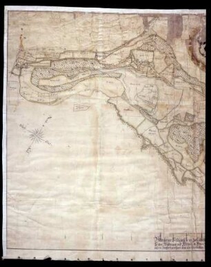
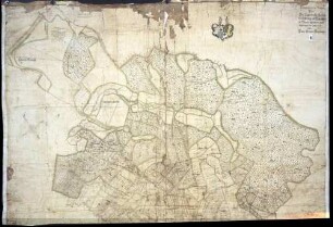
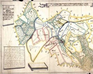
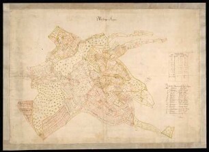
Abt. Staatsarchiv Sigmaringen, K I Ho/12
- Dimensions
-
250 x 205 cm (Höhe x Breite)
- Further information
-
Schaden: Erhaltungszustand: Schwer beschädigt, das Papier z.T. abgeplatzt
Ausführung: Handzeichnung
- Context
-
Karten und Pläne >> K I: Handgezeichnete Karten bis 1806 >> I Ho = Hohenfels
- Holding
-
Landesarchiv Baden-Württemberg, Abt. Staatsarchiv Sigmaringen, K Karten und Pläne
- Indexentry person
-
Stemmer, Anton; Hauptmann
- Indexentry place
-
Mindersdorf, Hohenfels KN
- Creator
-
Autor/Fotograf: Stemmer, Anton, Hauptmann
- Date of creation
-
1773
- Other object pages
- View digital item at providers-website
- Rights
-
Es gelten die Nutzungsbedingungen des Landesarchivs Baden-Württemberg.
- Last update
-
25.02.0001, 2:30 PM CET
Data provider
This object is provided by:
Landesarchiv Baden-Württemberg. If you have any questions about the object, please contact the data provider.
Landesarchiv Baden-Württemberg. If you have any questions about the object, please contact the data provider.
Object type
- Karten und Pläne
Associated
- Autor/Fotograf: Stemmer, Anton, Hauptmann
Time of origin
- 1773
Other Objects (12)
Geometrische Karte (Mappa) über die Deutschordensherrschaft Hohenfels
Geometrische Mappa über das hochadelige Stift Kloster Wald
Geometrische "Mappa" über den Selgetsweiler und Vogelsanger Bann
Geometrische Mappa über das Wieckenholzes und übrigen Bezürcks ...
Geometrische Mappa über das Gotteshaus S. Gallen aigenthümliche Güttere ...
Geometrische "Mappa" über den Hohenfelsischen Rappenhof und Neumühler Bann
Geometrische "Mappa" über den Liggersdorfer, Kalkofer, Schernegger und Hagendorner Bann

Geometrische "Mappa" über den Bann zu Breitenerlen, Heggelbach, Höllsteig und Waldsteig
"Mappa" über Mühlhausen: "Mappa" der Kaplanei-Lehen
"Mörsinger Mappa"
"Zeller Mappa"

"Enzisreuter Mappa"
Geometrische Karte (Mappa) über die Deutschordensherrschaft Hohenfels
Geometrische Mappa über das hochadelige Stift Kloster Wald
Geometrische "Mappa" über den Selgetsweiler und Vogelsanger Bann
Geometrische Mappa über das Wieckenholzes und übrigen Bezürcks ...
Geometrische Mappa über das Gotteshaus S. Gallen aigenthümliche Güttere ...
Geometrische "Mappa" über den Hohenfelsischen Rappenhof und Neumühler Bann
Geometrische "Mappa" über den Liggersdorfer, Kalkofer, Schernegger und Hagendorner Bann
Geometrische "Mappa" über den Bann zu Breitenerlen, Heggelbach, Höllsteig und Waldsteig
"Mappa" über Mühlhausen: "Mappa" der Kaplanei-Lehen
"Mörsinger Mappa"
"Zeller Mappa"