Altkarte
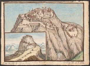
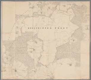
Plan // der // Berg und Hüttenwercke // von // GEORGENTHAL : im S. Erzgebürge - BSB Cod.icon. 180 vao
- Alternative title
-
Mapp. XII,127 gh
Berg- und Hüttenwerke sudetischen Erzgebirge
- Location
-
München, Bayerische Staatsbibliothek -- Cod.icon. 180 vao
- Dimensions
-
je Bl. 63 x 44 cm, Gesamtgröße 167 x 69 cm
- Extent
-
Ausstattung: 1 Karte in 6 Teilen auf 6 Bl.: Aquarell und Tusche auf Papier
- Language
-
Deutsch
- Notes
-
Ill.
Ausstattung: 1 Karte in 6 Teilen auf 6 Bl.: Aquarell und Tusche auf Papier. Detaillierte topographische Karte, Berge in Hangschraffenmanier. Region: Georgenthal
Maßstab in graphischer Form (200 Ellen = 17,5 cm)
Mit Legende "PETROGRAPHISCHE ZEICHEN" (19 Zeichen)
BSB-Provenienz: Mit grünem Signaturschildchen Inv.No. 1264. Mit Stempel P.C. 1817 D.S.T.B. und mit Bleistift 3437 auf der Rückseite
Altsignatur: Mapp. XII,127 gh
Kurzaufnahme einer Handschrift
- Keyword
-
Georgenthal
- Event
-
Herstellung
- (where)
-
[S.l.]
- (when)
-
s.a. [ca. 1850]
- Contributor
-
Arensberg, Maximilian von
- URN
-
urn:nbn:de:bvb:12-bsb00111801-6
- Last update
-
16.04.2025, 8:44 AM CEST
Data provider
This object is provided by:
Bayerische Staatsbibliothek. If you have any questions about the object, please contact the data provider.
Bayerische Staatsbibliothek. If you have any questions about the object, please contact the data provider.
Object type
- Altkarte
Associated
- Arensberg, Maximilian von
Time of origin
- s.a. [ca. 1850]
Other Objects (12)
Hohen Twiel ao. 1703 - BSB Cod.icon. 180 vbf
Carte von den beiden Ober-Aemter Zweybrucken und Hombourg - BSB Cod.icon. 180 tn
![[Festung Germersheim mit Schanzwerken] - BSB Cod.icon. 180 uon](https://iiif.deutsche-digitale-bibliothek.de/image/2/7509bea1-541b-44df-b6f3-3902ccef80b9/full/!306,450/0/default.jpg)
[Festung Germersheim mit Schanzwerken] - BSB Cod.icon. 180 uon
Augsburg und Umgebung - BSB Cod.icon. 180 uvu(1

Lageplan der Bundesfestung Landau - BSB Cod.icon. 180 g
Haag Reichsgrafschaft in Bayern - BSB Cod.icon. 180 i(22 : Skelet zu einer geographisch-statistischen Beschreibung dieser Grafschaft

Landkarte, Plan oder Situationszeichnung - BSB Cod.icon. 180 i(27

Landkarte, Plan oder Situationszeichnung - BSB Cod.icon. 180 i(13
Landkarte, Plan oder Situationszeichnung - BSB Cod.icon. 180 i(3

Landkarte, Plan oder Situationszeichnung - BSB Cod.icon. 180 i(21
Landkarte, Plan oder Situationszeichnung - BSB Cod.icon. 180 i(10
Landkarte, Plan oder Situationszeichnung - BSB Cod.icon. 180 i(17
Hohen Twiel ao. 1703 - BSB Cod.icon. 180 vbf
Carte von den beiden Ober-Aemter Zweybrucken und Hombourg - BSB Cod.icon. 180 tn
[Festung Germersheim mit Schanzwerken] - BSB Cod.icon. 180 uon
Augsburg und Umgebung - BSB Cod.icon. 180 uvu(1
Lageplan der Bundesfestung Landau - BSB Cod.icon. 180 g
Haag Reichsgrafschaft in Bayern - BSB Cod.icon. 180 i(22 : Skelet zu einer geographisch-statistischen Beschreibung dieser Grafschaft
Landkarte, Plan oder Situationszeichnung - BSB Cod.icon. 180 i(27
Landkarte, Plan oder Situationszeichnung - BSB Cod.icon. 180 i(13
Landkarte, Plan oder Situationszeichnung - BSB Cod.icon. 180 i(3
Landkarte, Plan oder Situationszeichnung - BSB Cod.icon. 180 i(21
Landkarte, Plan oder Situationszeichnung - BSB Cod.icon. 180 i(10