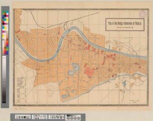
Stadtplan
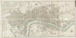
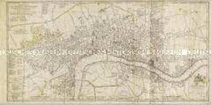
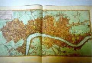
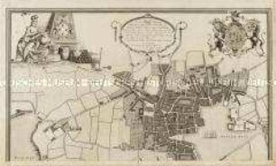
A Plan of the Cities of London & Westminster, The Borough Of Southwark, and their Suburbs
- Alternative title
-
A PLAN / of the CITIES of / LONDON & WESTMINSTER / THE BOROUGH OF
- Location
-
Deutsches Historisches Museum, Berlin
- Inventory number
-
Do 2006/312
- Measurements
-
Höhe x Breite: 54,2 x 75 cm (Blatt)
Höhe x Breite: 49 x 68,8 cm (Karte)
Höhe x Breite: 50,8 x 70,2 cm (Platte)
- Material/Technique
-
Druckfarbe, Papier, Kupferstich
- Classification
-
Kartografie (Gattung)
- Subject (what)
-
London
Westminster
- Event
-
Herstellung
- (who)
-
Verleger, Kartograf, Stecher: William Faden
Stecher: William Palmer
- (where)
-
London, Großbritannien und Nordirland
- (when)
-
1785
- Rights
-
Deutsches Historisches Museum
- Last update
-
24.03.2023, 9:28 AM CET
Data provider
This object is provided by:
Stiftung Deutsches Historisches Museum. If you have any questions about the object, please contact the data provider.
Stiftung Deutsches Historisches Museum. If you have any questions about the object, please contact the data provider.
Object type
- Stadtplan
Associated
- Verleger, Kartograf, Stecher: William Faden
- Stecher: William Palmer
Time of origin
- 1785
Other Objects (12)
Bowles's New Pocket Plan of the Cities of London & Westminster; with the Borough of Southwark
A New Plan of the City and Liberty of Westminster / A New Plan of the City of London and Borough of Southwark
Faden, William: A NEW POCKET PLAN OF THE CITIES OF LONDON / WESTMINSTER: WITH THE BOROUGH OF SOUTHWARK: Comprehending the New Buildings and other Alterations to the YEAR 1790. London (1790)

A Plan of the City of Dresden
A Plan of the Town and Citadel of Plymouth
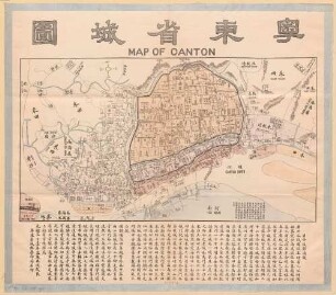
Map of Canton
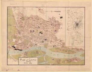
Plan of Cairo
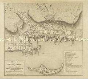
A Plan of the Town of Newport in Rhode Island.
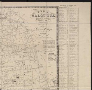
Plan of Calcutta : shewing the latest improvements as existing in 1854 ; with part of the environs
Plan of the foreign concessions in Tientsin
Thematischer Stadtplan: The Great Flood of Florence, November 4, 1966
Königsberg und Pillau : mit e. Beschreibg d. Häfen u. Auszügen aus d. einschlägigen Hafen- u. Polizeiverordngn = Map of the Port of Koenigsberg and Pillau
Bowles's New Pocket Plan of the Cities of London & Westminster; with the Borough of Southwark
A New Plan of the City and Liberty of Westminster / A New Plan of the City of London and Borough of Southwark
Faden, William: A NEW POCKET PLAN OF THE CITIES OF LONDON / WESTMINSTER: WITH THE BOROUGH OF SOUTHWARK: Comprehending the New Buildings and other Alterations to the YEAR 1790. London (1790)
A Plan of the City of Dresden
A Plan of the Town and Citadel of Plymouth
Map of Canton
Plan of Cairo
A Plan of the Town of Newport in Rhode Island.
Plan of Calcutta : shewing the latest improvements as existing in 1854 ; with part of the environs
Plan of the foreign concessions in Tientsin
Thematischer Stadtplan: The Great Flood of Florence, November 4, 1966