Karte
Die Provinz Westfalen, eingetheilt in die Regierungsbezirke Münster, Minden & Arnsberg
- Location
-
München, Bayerische Staatsbibliothek -- 2 Mapp. 176 s#B,2.Lfg.,5
- Dimensions
-
38 x 29 cm
- Extent
-
1 Kt.
- Language
-
Deutsch
- Notes
-
Lithographie
Mit 2 Nebenkt.: Gegend um Münster. Neu Salzwerk und Oeyenhausen's Bad
- Bibliographic citation
-
Der Preussische Staat ; No. 5 (2. Lfg., 1856)
- Keyword
-
Westfalen
- Event
-
Veröffentlichung
- (where)
-
Gotha
- (who)
-
Perthes
- (when)
-
1856
- Contributor
- URN
-
urn:nbn:de:bvb:12-bsb00042553-2
- Last update
-
04.10.190728635, 10:00 PM CET
Data provider
This object is provided by:
Bayerische Staatsbibliothek. If you have any questions about the object, please contact the data provider.
Bayerische Staatsbibliothek. If you have any questions about the object, please contact the data provider.
Object type
- Karte
Associated
- Berghaus, Heinrich
- Schilling, Theodor
- Alt, Wilhelm
- Hase, W.
- Perthes
Time of origin
- 1856
Other Objects (12)
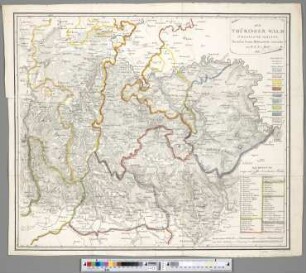
Der Thüringer Wald : Südöstliche Haelfte
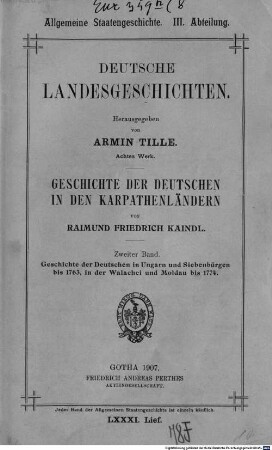
Geschichte der Deutschen in den Karpathenländern, 2. Geschichte der Deutschen in Ungarn und Siebenbürgen bis 1763, in der Walachei und Moldau bis 1774
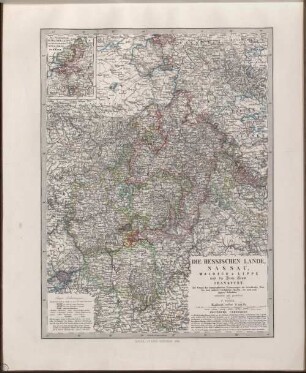
Die Hessischen Lande, Nassau, Waldeck & Lippe und die Freie Stadt Frankfurt : auf Grund der topographischen Vermessungen der betreffenden Staaten und anderer vorzüglicher Quellen, wie auch nach eigenen Aufnahmen

Deutsch-österreichisch-russischer Kriegsschauplatz : Auf Grund von Karten aus Stielers Hand-Atlas
Deutsch-französisch-belgischer Kriegsschauplatz : Auf Grund der Kten aus Stielers Handatlas ; [Mit Nebenkte]
Schul-Atlas der Alten Welt : Nach Mannert, Ukert, Reichard, Kruse, Wilhelm u. a. bearbeitet
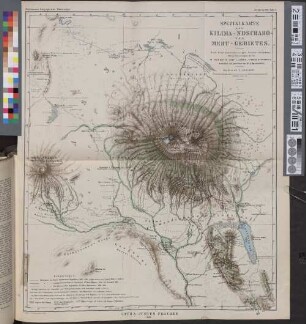
Spezialkarte des Kilima-Ndscharo- und Meru-Gebietes : nach Breitenbestimmungen, Routenaufnahmen, Winkelmessungen &c von Hans Meyer, v. Höhnel, Oscar Baumann u. a.
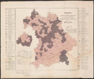
Charte über die politische Färbung Bayerns zur Zeit des Landtags 1855 : eingetheilt in Regierungs-Bezirke und Wahlbezirke
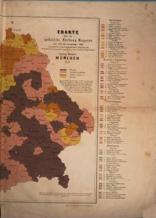
Charte über die politische Färbung Bayerns zur Zeit des Landtags 1855 : eingetheilt in Regierungs-Bezirke u. Wahlbezirke
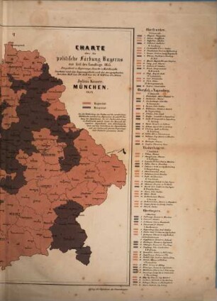
Charte über die politische Färbung Bayerns zur Zeit des Landtags 1849 : eingetheilt in Regierungs-Bezirke und Wahlbezirke
K. von Spruners historisch-geographischer Schul-Atlas
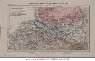
Spuren der Eiszeiten in Norddeutschland
Der Thüringer Wald : Südöstliche Haelfte
Geschichte der Deutschen in den Karpathenländern, 2. Geschichte der Deutschen in Ungarn und Siebenbürgen bis 1763, in der Walachei und Moldau bis 1774
Die Hessischen Lande, Nassau, Waldeck & Lippe und die Freie Stadt Frankfurt : auf Grund der topographischen Vermessungen der betreffenden Staaten und anderer vorzüglicher Quellen, wie auch nach eigenen Aufnahmen
Deutsch-österreichisch-russischer Kriegsschauplatz : Auf Grund von Karten aus Stielers Hand-Atlas
Deutsch-französisch-belgischer Kriegsschauplatz : Auf Grund der Kten aus Stielers Handatlas ; [Mit Nebenkte]
Schul-Atlas der Alten Welt : Nach Mannert, Ukert, Reichard, Kruse, Wilhelm u. a. bearbeitet
Spezialkarte des Kilima-Ndscharo- und Meru-Gebietes : nach Breitenbestimmungen, Routenaufnahmen, Winkelmessungen &c von Hans Meyer, v. Höhnel, Oscar Baumann u. a.
Charte über die politische Färbung Bayerns zur Zeit des Landtags 1855 : eingetheilt in Regierungs-Bezirke und Wahlbezirke
Charte über die politische Färbung Bayerns zur Zeit des Landtags 1855 : eingetheilt in Regierungs-Bezirke u. Wahlbezirke
Charte über die politische Färbung Bayerns zur Zeit des Landtags 1849 : eingetheilt in Regierungs-Bezirke und Wahlbezirke
K. von Spruners historisch-geographischer Schul-Atlas