Altkarte | Stadtplan
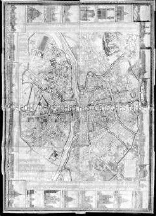
Plan of the City of New York in North America : Surveyed in the Years 1766 & 1767 ; [gewidmet] Sir Henry Moore
- Standort
-
München, Bayerische Staatsbibliothek -- Mapp. XXII,204 w
- Maße
-
Gesamtgr. 86 x 98 cm, Bildgr. 86 x 118 cm
- Umfang
-
1 Plan auf 3 Bl.
- Anmerkungen
-
Kupferstich
Maßstab in graph. Form (Feet, Mile, Yards). - Mit 1 Stadtansicht: A South West View of the City of New York, taken from the Governours Island. - Mit Böschungsschraffen
- Schlagwort
-
New York, NY
- Ereignis
-
Veröffentlichung
- (wo)
-
London
- (wer)
-
Jefferys & Faden
- (wann)
-
1776
- Beteiligte Personen und Organisationen
- URN
-
urn:nbn:de:bvb:12-bsb00108599-1
- Letzte Aktualisierung
-
16.04.2025, 08:35 MESZ
Datenpartner
Dieses Objekt wird bereitgestellt von:
Bayerische Staatsbibliothek. Bei Fragen zum Objekt wenden Sie sich bitte an den Datenpartner.
Bayerische Staatsbibliothek. Bei Fragen zum Objekt wenden Sie sich bitte an den Datenpartner.
Objekttyp
- Altkarte
- Stadtplan
Beteiligte
- Ratzer, Bernard
- Kitchin, Thomas
- Jefferys, Thomas
- Faden, William
- Jefferys & Faden
Entstanden
- 1776
Ähnliche Objekte (12)

Stadtatlas Großraum Bremen : Cuxhaven, Norden, Wilhelmshaven, Bremerhaven, Aurich, Emden, Leer (Ostfriesland), Oldenburg, Papenburg, Delmenhorst, Verden (Aller), Wildeshausen, Cloppenburg ; über 60 Städte und Gemeinden im Großraum Bremen von Langen bis Bassum und von Bad Zwischenahn bis Verden (Aller) ; mit Ausflugsgebieten (1:150000) Ostfriesische Inseln, Ostfriesland, Land Hadeln, Land Kehdingen, Ammerland, Teufelsmoor, Hondsrug, Bourtanger Moor, Hümmling, Oldenburger Münsterland, Emsland und Dammer Berge
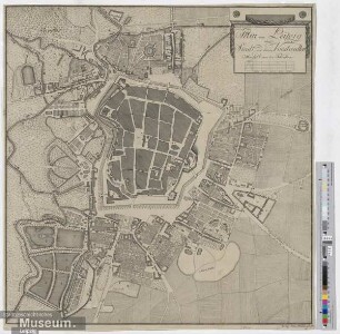
Plan von Leipzig der Stadt und denen Vorstaedten
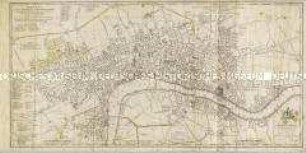
A New Plan of the City and Liberty of Westminster / A New Plan of the City of London and Borough of Southwark
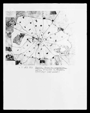
Paris, Stadtplan mit Erweiterungsplan, Projekt E. Hénard

ohne Titel
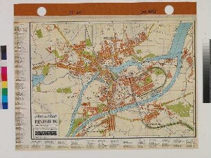
Plan der Stadt RENDSBURG

Thematischer Stadtplan der Stadt während der Überschwemmung von 1966: Altezza raggiunta dalle acque nelle varie zone
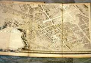
Nouveau Plan Routier De la Ville et Faubourgs de Paris Avec ses Principaux Edifices et Nouvelles Barrieres; 18. Jh., Abzug von 1803
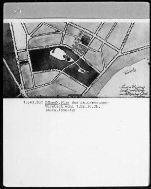
Lübeck. Plan der Sankt Gertruden-Vorstadt
![Vogelschaubild von Gotha, Kupferstich, um 1567 : Disegno della Fortezza et Citta di Gotta in Sassonia. - Nicht maßstäbig. - [Venetia : P. Bertelli, um 1567]. - 1 Vogelschaubild : Kupferstich ; 19 x 28 cm // Gesamtansicht aus der halben Vogelschau mit eingezeichneten Belagerungstruppen und -lagern im Vordergrund](https://iiif.deutsche-digitale-bibliothek.de/image/2/88200713-2b58-48e3-a21b-b92bc3d545ce/full/!306,450/0/default.jpg)
Vogelschaubild von Gotha, Kupferstich, um 1567 : Disegno della Fortezza et Citta di Gotta in Sassonia. - Nicht maßstäbig. - [Venetia : P. Bertelli, um 1567]. - 1 Vogelschaubild : Kupferstich ; 19 x 28 cm // Gesamtansicht aus der halben Vogelschau mit eingezeichneten Belagerungstruppen und -lagern im Vordergrund

Stadtplan von Berlin
PLAN de PARIS. Vogelschauplan
Stadtatlas Großraum Bremen : Cuxhaven, Norden, Wilhelmshaven, Bremerhaven, Aurich, Emden, Leer (Ostfriesland), Oldenburg, Papenburg, Delmenhorst, Verden (Aller), Wildeshausen, Cloppenburg ; über 60 Städte und Gemeinden im Großraum Bremen von Langen bis Bassum und von Bad Zwischenahn bis Verden (Aller) ; mit Ausflugsgebieten (1:150000) Ostfriesische Inseln, Ostfriesland, Land Hadeln, Land Kehdingen, Ammerland, Teufelsmoor, Hondsrug, Bourtanger Moor, Hümmling, Oldenburger Münsterland, Emsland und Dammer Berge
Plan von Leipzig der Stadt und denen Vorstaedten
A New Plan of the City and Liberty of Westminster / A New Plan of the City of London and Borough of Southwark
Paris, Stadtplan mit Erweiterungsplan, Projekt E. Hénard
ohne Titel
Plan der Stadt RENDSBURG
Thematischer Stadtplan der Stadt während der Überschwemmung von 1966: Altezza raggiunta dalle acque nelle varie zone
Nouveau Plan Routier De la Ville et Faubourgs de Paris Avec ses Principaux Edifices et Nouvelles Barrieres; 18. Jh., Abzug von 1803
Lübeck. Plan der Sankt Gertruden-Vorstadt
Vogelschaubild von Gotha, Kupferstich, um 1567 : Disegno della Fortezza et Citta di Gotta in Sassonia. - Nicht maßstäbig. - [Venetia : P. Bertelli, um 1567]. - 1 Vogelschaubild : Kupferstich ; 19 x 28 cm // Gesamtansicht aus der halben Vogelschau mit eingezeichneten Belagerungstruppen und -lagern im Vordergrund
Stadtplan von Berlin