Monografie
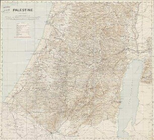
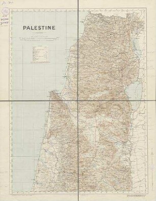
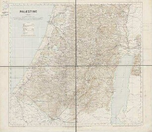
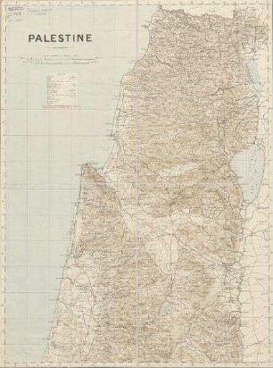
Topographical & physical map of Palestine : compiled from the Palestine exploration fund surveys and other authorities

- Weitere Titel
-
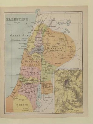
A @new topographical, physical, and biblical map of Palestine
- Standort
-
Universitäts- und Landesbibliothek Sachsen-Anhalt -- Altkt V I [3] 1 / 5
- Umfang
-
1 Karte; 131 x 89 cm, gefaltet 28 x 17 cm, farbig, 1 Index (14 Seiten)
- Sprache
-
Englisch
- Anmerkungen
-
Mit 2 Profilen : "Section across Galilee and the Jordan Valley", "Section across Judea and the Dead Sea"
Mit 3 Nebenkarten: "Vegetation map of modern Palestine", "Plan of Jerusalem from the Ordnance survey", "London on same scale as large map - 4 miles to an inch"
Mit Suchnetz
under the direction of J.G. Bartholomew, F.R.S.E., F.R.G.S. and edited by George Adam Smith, D.D., L L.D. ; the Edinburgh Geographical Institute
Karte
- Reihe
-
Bartholomew's World survey map series
- Beteiligte Personen und Organisationen
- Erschienen
-
Edinburgh : published by T. & T. Clark , 1901
- Förderung
-
Die Digitalisierung wurde gefördert durch die Deutsche Digitale Bibliothek aus Mitteln des Programms „Neustart Kultur“ der Beauftragten der Bundesregierung für Kultur und Medien.
- DOI
-
doi:10.25673/39646
- URN
-
urn:nbn:de:gbv:3:3-1192015415-1407072692-11
- Letzte Aktualisierung
-
03.06.2025, 07:51 MESZ
Datenpartner
Dieses Objekt wird bereitgestellt von:
Martin-Luther-Universität Halle-Wittenberg, Universitäts- und Landesbibliothek Sachsen-Anhalt. Bei Fragen zum Objekt wenden Sie sich bitte an den Datenpartner.
Martin-Luther-Universität Halle-Wittenberg, Universitäts- und Landesbibliothek Sachsen-Anhalt. Bei Fragen zum Objekt wenden Sie sich bitte an den Datenpartner.
Objekttyp
- Monografie
Beteiligte
Entstanden
- Edinburgh : published by T. & T. Clark , 1901
Ähnliche Objekte (12)
Palestine

Palestine
Palestine

Palestine
PALESTINE
Palestine
Palestine
Palestine
Palestine. Jéricho.
Palestine Fees
Palestine. Tiberias.
Democratic Palestine
Palestine
Palestine
Palestine
Palestine
PALESTINE
Palestine
Palestine
Palestine
Palestine. Jéricho.
Palestine Fees
Palestine. Tiberias.
Democratic Palestine
Palestine
Palestine
Palestine
Palestine
PALESTINE
Palestine
Palestine
Palestine
Palestine. Jéricho.
Palestine Fees
Palestine. Tiberias.