Karten und Pläne
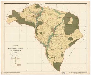
[Holznutzungsplan des Mönchschlags (Münchschlag) im Katzental]
- Reference number
-
Landesarchiv Baden-Württemberg, Abt. Staatsarchiv Wertheim, R-K Nr. 429
- Dimensions
-
38 x 50 (Höhe x Breite)
- Further information
-
Ausführung: Federzeichnung; handkoloriert
Maßstab: [1:4800]
- Context
-
Karten und Pläne >> B. Baden >> B.11. Külsheim >> B.11.5. Steinfurt
- Holding
-
Landesarchiv Baden-Württemberg, Abt. Staatsarchiv Wertheim, R-K Karten und Pläne
- Creator
-
Autor/Fotograf: Hofmann
- Date of creation
-
1840
- Other object pages
- View digital item at providers-website
- Rights
-
Es gelten die Nutzungsbedingungen des Landesarchivs Baden-Württemberg.
- Last update
-
26.03.2024, 9:03 AM CET
Data provider
This object is provided by:
Landesarchiv Baden-Württemberg. If you have any questions about the object, please contact the data provider.
Landesarchiv Baden-Württemberg. If you have any questions about the object, please contact the data provider.
Object type
- Karten und Pläne
Associated
- Autor/Fotograf: Hofmann
Time of origin
- 1840
Other Objects (12)

Flurkarte Gemarkung Katzental
Flurkarte Gemarkung Katzental
Flurkarte Gemarkung Katzental
Flurkarte Gemarkung Katzental
Katzental (Billigheim MOS) und Waldmühlbach
![[obere Hut] "Sulzbronnen, Katzental und Sießerhalden ..."](https://iiif.deutsche-digitale-bibliothek.de/image/2/9b8400f6-d759-42aa-a4bf-f01e2099421f/full/!306,450/0/default.jpg)
[obere Hut] "Sulzbronnen, Katzental und Sießerhalden ..."
Gemarkung Katzental Steitbusch Blattnummer 6621.9 Deutsche Grundkarte
![[Neuvermessung der Güter des Hofs Breitenau im Katzental] (Inselkarte)](https://iiif.deutsche-digitale-bibliothek.de/image/2/23870835-5e48-48b8-861c-13911374195f/full/!306,450/0/default.jpg)
[Neuvermessung der Güter des Hofs Breitenau im Katzental] (Inselkarte)
Volksschule Katzental, Grundschule Katzental
Situationsplan über die projektierte Drainage [Hofgut Katzental - Unter Riedern]
Katzental
Katzental
Flurkarte Gemarkung Katzental
Flurkarte Gemarkung Katzental
Flurkarte Gemarkung Katzental
Flurkarte Gemarkung Katzental
Katzental (Billigheim MOS) und Waldmühlbach
[obere Hut] "Sulzbronnen, Katzental und Sießerhalden ..."
Gemarkung Katzental Steitbusch Blattnummer 6621.9 Deutsche Grundkarte
[Neuvermessung der Güter des Hofs Breitenau im Katzental] (Inselkarte)
Volksschule Katzental, Grundschule Katzental
Situationsplan über die projektierte Drainage [Hofgut Katzental - Unter Riedern]
Katzental