Karten und Pläne
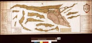
Wasserversorgung der Kartause Grünau
Enthält: Strangschema und Lageskizze
- Reference number
-
Landesarchiv Baden-Württemberg, Abt. Staatsarchiv Wertheim, F-K Nr. 569
- Dimensions
-
28,5 x 38 (Höhe x Breite)
- Notes
-
aus StAWt-F 218 Nr. 722
- Further information
-
Ausführung: Lichtpause
- Context
-
Karten und Pläne >> C. Bayern >> C.12. Schollbrunn >> C.12.4. Grünau
- Holding
-
Landesarchiv Baden-Württemberg, Abt. Staatsarchiv Wertheim, F-K Karten und Pläne
- Creator
-
Autor/Fotograf: Hiller
- Date of creation
-
1. Juli 1970
- Other object pages
- Rights
-
Es gelten die Nutzungsbedingungen des Landesarchivs Baden-Württemberg.
- Last update
-
26.03.2024, 9:03 AM CET
Data provider
This object is provided by:
Landesarchiv Baden-Württemberg. If you have any questions about the object, please contact the data provider.
Landesarchiv Baden-Württemberg. If you have any questions about the object, please contact the data provider.
Object type
- Karten und Pläne
Associated
- Autor/Fotograf: Hiller
Time of origin
- 1. Juli 1970
Other Objects (12)

Kartause Grünau
Kartause Grünau
Kartause Grünau
Kartause Grünau
Kartause Grünau
Kartause Grünau
Kartause Grünau
Hofgut Kartause Grünau
Kartause Grünau: Umbau der Gaststätte
Kartause Grünau: Abortanlage im Wohnhaus
Kirche in der Kartause Grünau (Rekonstruktionszeichnung)
Versorgung der Kartause Grünau mit elektrischem Strom
Kartause Grünau
Kartause Grünau
Kartause Grünau
Kartause Grünau
Kartause Grünau
Kartause Grünau
Kartause Grünau
Hofgut Kartause Grünau
Kartause Grünau: Umbau der Gaststätte
Kartause Grünau: Abortanlage im Wohnhaus
Kirche in der Kartause Grünau (Rekonstruktionszeichnung)