Altkarte
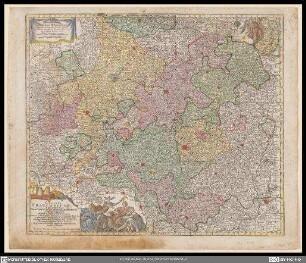
Geographische Mauth-Charte von Baeÿern : Vorstellend: alle zu Wasser und zu Land hergebrachte Mauth-Stationen u. Accis-Aemter, samt denen dahin-fuehrenden Commercial- u. Land-Strassen ; entworfen Anno 1764 ; [gewidmet] Maximilianus III
- Alternative title
-
Baeÿern
- Location
-
München, Bayerische Staatsbibliothek -- Mapp. XI,580 a
- Dimensions
-
65 x 54 cm
- Extent
-
1 Kt.
- Edition
-
Renovirt 1768
- Notes
-
Kupferstich
Maßstab in graph. Form (Milliaria Germanica Communia, Milliaria Bavar. magna). - Mit Verz. d. Mauth-Stationen. - Mit Wegeangaben auf d. Kt.
- Keyword
-
Geschichte 1623-1805
Straßennetz
Zollgrenze
Wasserstraße
Bayern
- Event
-
Veröffentlichung
- (where)
-
Aug. Vind.//Augsburg//
- (when)
-
1768
- Contributor
- URN
-
urn:nbn:de:bvb:12-bsb00002290-8
- Last update
-
27.11.2025, 8:37 AM CET
Data provider
This object is provided by:
Bayerische Staatsbibliothek. If you have any questions about the object, please contact the data provider.
Bayerische Staatsbibliothek. If you have any questions about the object, please contact the data provider.
Object type
- Altkarte
Time of origin
- 1768
Other Objects (12)

Geographische Mauth-Charte von Baeÿern : Vorstellend: alle zu Wasser und zu Land hergebrachte Mauth-Stationen u. Accis-Aemter, samt denen dahin-fuehrenden Commercial- und Land-Strassen ; entworfen Anno 1764

Geographische Mauth-Charte von dem Herzogthum der Obern Pfalz und der Landgrafschaft Leuchtenberg : Vorstellung Deren alther gebrachten Mauth- und Zoll-Stationen, und Accis-Aemter samt den dahinführenden Commercial- und Land-Strassen

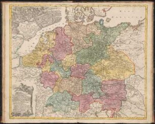
Nova Et Exacta Mappa Geographica exhibens Circulum Westphalicum
Circulus Franconicus
Mappa Geographica exhibens Postas omnes tam vehiculares quam veredarias Totius Germaniæ : cum earum accurata distantia

Helvetiae, Rhaetia, Valesiae und Partis Sabaudiae Tabula

Ducatus Wurtembergici cum Territoriis conterminis

Superioris atque inferioris Alsatiae

Geographia Silesiae, 0

Topographia Sedis Imperatoriae Moscovitarum Petropolis : anno 1744 designata iam publici iuris facta ; Cum Grat. et Privil. S. R. I. Vicariatus, in part. Rheni, Sveviae, et Iur. Franc. = Plan der Kayserlichen Residentz-Stadt Sankt Petersburg
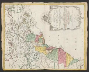
Carte Nouvelle de l'Amerique Angloise : contenant tout ce que les Anglois possedent sur le Continent de l'Amerique Septentrionale Savoir le Canada, la Nouvelle Ecosse ou Acadie, les treize Provinces unies qui sont: les quatres Colonies de la Nouvelle Angleterre 1. New Hampshire, 2. Massachusetsbaye, 3. Rhode-Island, & 4. Conecticut, 5. la Nouvelle York, 6. Nouvelle Jersey, 7. Pensilvanie, 8. les Comtés de Newcastle Kent et Sussex sur la Delaware, 9. Mariland, 10. Virginie, 11. la Caroline Septentrionale, 12. la Caroline Meridionale et 13. Georgie: avec la Floride
Germaniae Aliorumque Quorundam Loco-rum Europae Poliometria
Geographische Mauth-Charte von Baeÿern : Vorstellend: alle zu Wasser und zu Land hergebrachte Mauth-Stationen u. Accis-Aemter, samt denen dahin-fuehrenden Commercial- und Land-Strassen ; entworfen Anno 1764
Geographische Mauth-Charte von dem Herzogthum der Obern Pfalz und der Landgrafschaft Leuchtenberg : Vorstellung Deren alther gebrachten Mauth- und Zoll-Stationen, und Accis-Aemter samt den dahinführenden Commercial- und Land-Strassen
Nova Et Exacta Mappa Geographica exhibens Circulum Westphalicum
Circulus Franconicus
Mappa Geographica exhibens Postas omnes tam vehiculares quam veredarias Totius Germaniæ : cum earum accurata distantia
Helvetiae, Rhaetia, Valesiae und Partis Sabaudiae Tabula
Ducatus Wurtembergici cum Territoriis conterminis
Superioris atque inferioris Alsatiae
Geographia Silesiae, 0
Topographia Sedis Imperatoriae Moscovitarum Petropolis : anno 1744 designata iam publici iuris facta ; Cum Grat. et Privil. S. R. I. Vicariatus, in part. Rheni, Sveviae, et Iur. Franc. = Plan der Kayserlichen Residentz-Stadt Sankt Petersburg
Carte Nouvelle de l'Amerique Angloise : contenant tout ce que les Anglois possedent sur le Continent de l'Amerique Septentrionale Savoir le Canada, la Nouvelle Ecosse ou Acadie, les treize Provinces unies qui sont: les quatres Colonies de la Nouvelle Angleterre 1. New Hampshire, 2. Massachusetsbaye, 3. Rhode-Island, & 4. Conecticut, 5. la Nouvelle York, 6. Nouvelle Jersey, 7. Pensilvanie, 8. les Comtés de Newcastle Kent et Sussex sur la Delaware, 9. Mariland, 10. Virginie, 11. la Caroline Septentrionale, 12. la Caroline Meridionale et 13. Georgie: avec la Floride