Altkarte
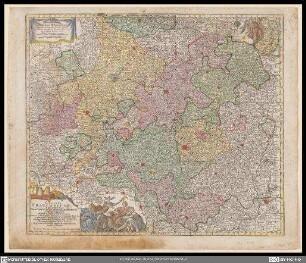
Geographische Mauth-Charte von dem Herzogthum der Obern Pfalz und der Landgrafschaft Leuchtenberg : Vorstellung Deren alther gebrachten Mauth- und Zoll-Stationen, und Accis-Aemter samt den dahinführenden Commercial- und Land-Strassen
- Location
-
München, Bayerische Staatsbibliothek -- Mapp. XI,255
- Dimensions
-
95 x 79 cm
- Extent
-
1 Kt.
- Notes
-
Kupferstich
Maßstab in graph. Form
- Keyword
-
Straßennetz
Zollgrenze
Regierungsbezirk Oberpfalz
- Event
-
Veröffentlichung
- (where)
-
Aug. Vind.//Augsburg//
- (when)
-
1769
- Contributor
- URN
-
urn:nbn:de:bvb:12-bsb00014428-3
- Last update
- 27.11.2025, 8:36 AM CET
Data provider
This object is provided by:
Bayerische Staatsbibliothek. If you have any questions about the object, please contact the data provider.
Bayerische Staatsbibliothek. If you have any questions about the object, please contact the data provider.
Object type
- Altkarte
Time of origin
- 1769
Other Objects (12)

Geographische Mauth-Charte von Baeÿern : Vorstellend: alle zu Wasser und zu Land hergebrachte Mauth-Stationen u. Accis-Aemter, samt denen dahin-fuehrenden Commercial- und Land-Strassen ; entworfen Anno 1764
![Geographische Mauth-Charte von Baeÿern : Vorstellend: alle zu Wasser und zu Land hergebrachte Mauth-Stationen u. Accis-Aemter, samt denen dahin-fuehrenden Commercial- u. Land-Strassen ; entworfen Anno 1764 ; [gewidmet] Maximilianus III](https://iiif.deutsche-digitale-bibliothek.de/image/2/c88824de-9853-43db-9928-168b9206434a/full/!306,450/0/default.jpg)
Geographische Mauth-Charte von Baeÿern : Vorstellend: alle zu Wasser und zu Land hergebrachte Mauth-Stationen u. Accis-Aemter, samt denen dahin-fuehrenden Commercial- u. Land-Strassen ; entworfen Anno 1764 ; [gewidmet] Maximilianus III

Churbaierische Mauth- und Accis-Ordnung : Zur allgemeinen Beobachtung vorgeschrieben im Jahre 1765.

Churbaierische Mauth- und Accis-Ordnung : Zur allgemeinen Beobachtung vorgeschrieben im Jahre 1765.

Churbaierische Mauth- und Accis-Ordnung : Zur allgemeinen Beobachtung vorgeschrieben im Jahre 1765.

Churbaierische Mauth- und Accis-Ordnung : Zur allgemeinen Beobachtung vorgeschrieben im Jahre 1765.

Churbaierische Mauth- und Accis-Ordnung : Zur allgemeinen Beobachtung vorgeschrieben im Jahre 1765.

Churbaierische Mauth- und Accis-Ordnung : Zur allgemeinen Beobachtung vorgeschrieben im Jahre 1765.

Churbaierische Mauth- und Accis-Ordnung : Zur allgemeinen Beobachtung vorgeschrieben im Jahre 1765.

Churbaierische Mauth- und Accis-Ordnung : Zur allgemeinen Beobachtung vorgeschrieben im Jahre 1765.

Churbaierische Mauth- und Accis-Ordnung : Zur allgemeinen Beobachtung vorgeschrieben im Jahre 1765.
Circulus Franconicus
Geographische Mauth-Charte von Baeÿern : Vorstellend: alle zu Wasser und zu Land hergebrachte Mauth-Stationen u. Accis-Aemter, samt denen dahin-fuehrenden Commercial- und Land-Strassen ; entworfen Anno 1764
Geographische Mauth-Charte von Baeÿern : Vorstellend: alle zu Wasser und zu Land hergebrachte Mauth-Stationen u. Accis-Aemter, samt denen dahin-fuehrenden Commercial- u. Land-Strassen ; entworfen Anno 1764 ; [gewidmet] Maximilianus III
Churbaierische Mauth- und Accis-Ordnung : Zur allgemeinen Beobachtung vorgeschrieben im Jahre 1765.
Churbaierische Mauth- und Accis-Ordnung : Zur allgemeinen Beobachtung vorgeschrieben im Jahre 1765.
Churbaierische Mauth- und Accis-Ordnung : Zur allgemeinen Beobachtung vorgeschrieben im Jahre 1765.
Churbaierische Mauth- und Accis-Ordnung : Zur allgemeinen Beobachtung vorgeschrieben im Jahre 1765.
Churbaierische Mauth- und Accis-Ordnung : Zur allgemeinen Beobachtung vorgeschrieben im Jahre 1765.
Churbaierische Mauth- und Accis-Ordnung : Zur allgemeinen Beobachtung vorgeschrieben im Jahre 1765.
Churbaierische Mauth- und Accis-Ordnung : Zur allgemeinen Beobachtung vorgeschrieben im Jahre 1765.
Churbaierische Mauth- und Accis-Ordnung : Zur allgemeinen Beobachtung vorgeschrieben im Jahre 1765.
Churbaierische Mauth- und Accis-Ordnung : Zur allgemeinen Beobachtung vorgeschrieben im Jahre 1765.