Karten und Pläne
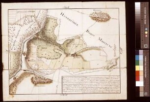
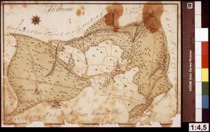
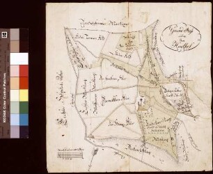
[Sämtliche Eingehörungen des Ernsthofs] (Inselkarte)
Enthält: Dörlesberg, Hundheim, Ernsthof, Geishöflein, Öl- und Ebenmühle im Grundriss
- Reference number
-
Landesarchiv Baden-Württemberg, Abt. Staatsarchiv Wertheim, R-K Nr. 406
- Dimensions
-
40 x 51 (Höhe x Breite)
- Notes
-
vgl. StAWt-R Lit. B 1164
- Further information
-
Ausführung: Federzeichnung; handkoloriert
Maßstab: [1:9000]
- Context
-
Karten und Pläne >> B. Baden >> B.22. Wertheim >> B.22.5. Dörlesberg >> B.22.5.2. Ernsthof
- Holding
-
Landesarchiv Baden-Württemberg, Abt. Staatsarchiv Wertheim, R-K Karten und Pläne
- Creator
-
Autor/Fotograf: [Füssl]
- Date of creation
-
[um 1832]
- Other object pages
- View digital item at providers-website
- Rights
-
Es gelten die Nutzungsbedingungen des Landesarchivs Baden-Württemberg.
- Last update
-
26.03.2024, 9:05 AM CET
Data provider
This object is provided by:
Landesarchiv Baden-Württemberg. If you have any questions about the object, please contact the data provider.
Landesarchiv Baden-Württemberg. If you have any questions about the object, please contact the data provider.
Object type
- Karten und Pläne
Associated
- Autor/Fotograf: [Füssl]
Time of origin
- [um 1832]
Other Objects (12)
![[Sämtliche Eingehörungen des Ernsthofs] (Inselkarte)](/assets/placeholder/searchResultMediaNoDigitisedMedia.png)
[Sämtliche Eingehörungen des Ernsthofs] (Inselkarte)
Karte über die sämtlichen Eingehörungen des Hofguts Ernsthof (Inselkarte)
Verjüngter Haupt- und Generalriss über sämtliche Eingehörungen zu dem Hof zu Hafenlohr (Inselkarte)
Karte über die sämtliche Eingehörungen des Ernsthofs

Neidelsbach: Sämtliche Neugereutszehntfelder (Inselkarte)
Helmstheim (Inselkarte)
Vielbrunn (Inselkarte)
Scheibenhardt (Inselkarte)
Otterhof (Inselkarte)
Scheibenhardt (Inselkarte)
Gickelfeld (Inselkarte)
Haidhof (Inselkarte)
[Sämtliche Eingehörungen des Ernsthofs] (Inselkarte)
Karte über die sämtlichen Eingehörungen des Hofguts Ernsthof (Inselkarte)
Verjüngter Haupt- und Generalriss über sämtliche Eingehörungen zu dem Hof zu Hafenlohr (Inselkarte)
Karte über die sämtliche Eingehörungen des Ernsthofs
Neidelsbach: Sämtliche Neugereutszehntfelder (Inselkarte)
Helmstheim (Inselkarte)
Vielbrunn (Inselkarte)
Scheibenhardt (Inselkarte)
Otterhof (Inselkarte)
Scheibenhardt (Inselkarte)
Gickelfeld (Inselkarte)