Altkarte
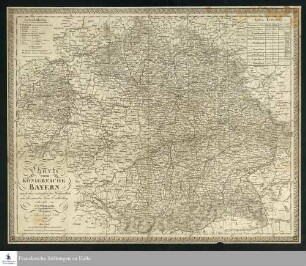
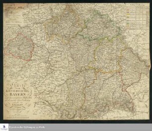
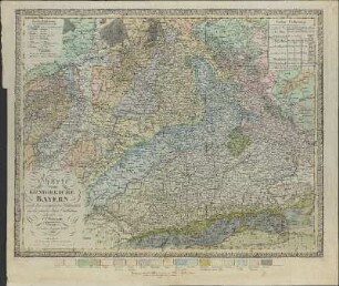
Charte vom Königreiche Bayern : nach den vorzüglichen Hülfsmitteln und der neuesten Kreis-Eintheilung
- Alternative title
-
Karte vom Königreich Bayern
- Location
-
München, Bayerische Staatsbibliothek -- Mapp. XXIV,82 e
- Dimensions
-
59 x 47 cm
- Extent
-
1 Kt.
- Edition
-
[Überarb. Ausg. d. Kt. Weimar: Verlag des Geograph. Instituts, 1826]
- Language
-
Deutsch
- Notes
-
kolor. Kupferstich
Maßstab in graph. Form (Deutsche Meilen). - Mit Bergstrichen. - Als Beil. zu: Teutschland, geognostisch-geologisch dargestellt / hrsg. von Christian Keferstein. - Bd. 6,1 (1828) erschienen
- Keyword
-
Geschichte 1821
Geologie
Bayern
- Event
-
Veröffentlichung
- (where)
-
Weimar
- (who)
-
Verl. des Landes-Industrie-Comptoir
- (when)
-
1828
- Creator
- Contributor
- URN
-
urn:nbn:de:bvb:12-bsb00090743-1
- Last update
-
16.04.2025, 8:40 AM CEST
Data provider
This object is provided by:
Bayerische Staatsbibliothek. If you have any questions about the object, please contact the data provider.
Bayerische Staatsbibliothek. If you have any questions about the object, please contact the data provider.
Object type
- Altkarte
Associated
- Keferstein, Christian
- Weiland, Karl Ferdinand
- Bürck, A.
- Verl. des Landes-Industrie-Comptoir
Time of origin
- 1828
Other Objects (12)
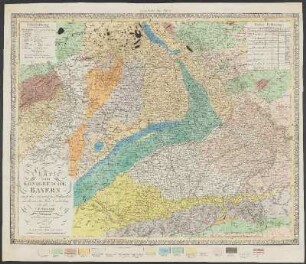
Charte vom Königreiche Bayern : nach den vorzüglichsten Hülfsmitteln und der neuesten Kreis-Eintheilung
Karte vom Königreiche Bayern nach den vorzüglichsten Hülfsmitteln und der neuesten Kreis-Eintheilung
Charte von Europa Nach den vorzüglichsten Hülfsmitteln und seiner neuesten Eintheilung entworfen - Leipzig 1819
Charte vom Königreiche Bayern : nach seiner neuesten Eintheilung vom Jahre 1810
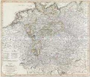
Charte von Deutschland nach der Eintheilung der rheinischen Bundesstaaten und den neuesten und zuverlässigsten Hülfsmitteln entworfen

Die Geschichte Bayerns aus den Quellen und anderen vorzüglichen Hülfsmitteln, T. 2
Die Geschichte Bayerns aus den Quellen und anderen vorzüglichen Hülfsmitteln, T. 1
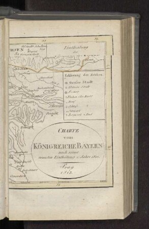
Charte vom Königreiche Bayern nach seiner neuesten Eintheilung v. Jahre 1810. Prag 1813.
Charte vom Königreiche Bayern
Charte vom Königreiche Bayern
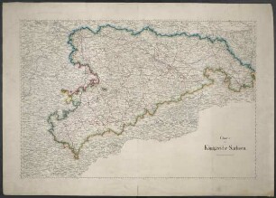
Charte vom Königreiche Sachsen

Charte vom Königreiche Bayern
Charte vom Königreiche Bayern : nach den vorzüglichsten Hülfsmitteln und der neuesten Kreis-Eintheilung
Karte vom Königreiche Bayern nach den vorzüglichsten Hülfsmitteln und der neuesten Kreis-Eintheilung
Charte von Europa Nach den vorzüglichsten Hülfsmitteln und seiner neuesten Eintheilung entworfen - Leipzig 1819
Charte vom Königreiche Bayern : nach seiner neuesten Eintheilung vom Jahre 1810
Charte von Deutschland nach der Eintheilung der rheinischen Bundesstaaten und den neuesten und zuverlässigsten Hülfsmitteln entworfen
Die Geschichte Bayerns aus den Quellen und anderen vorzüglichen Hülfsmitteln, T. 2
Die Geschichte Bayerns aus den Quellen und anderen vorzüglichen Hülfsmitteln, T. 1
Charte vom Königreiche Bayern nach seiner neuesten Eintheilung v. Jahre 1810. Prag 1813.
Charte vom Königreiche Bayern
Charte vom Königreiche Bayern
Charte vom Königreiche Sachsen
Charte vom Königreiche Bayern
Charte vom Königreiche Bayern : nach den vorzüglichsten Hülfsmitteln und der neuesten Kreis-Eintheilung
Karte vom Königreiche Bayern nach den vorzüglichsten Hülfsmitteln und der neuesten Kreis-Eintheilung
Charte von Europa Nach den vorzüglichsten Hülfsmitteln und seiner neuesten Eintheilung entworfen - Leipzig 1819
Charte vom Königreiche Bayern : nach seiner neuesten Eintheilung vom Jahre 1810
Charte von Deutschland nach der Eintheilung der rheinischen Bundesstaaten und den neuesten und zuverlässigsten Hülfsmitteln entworfen
Die Geschichte Bayerns aus den Quellen und anderen vorzüglichen Hülfsmitteln, T. 2
Die Geschichte Bayerns aus den Quellen und anderen vorzüglichen Hülfsmitteln, T. 1
Charte vom Königreiche Bayern nach seiner neuesten Eintheilung v. Jahre 1810. Prag 1813.
Charte vom Königreiche Bayern
Charte vom Königreiche Bayern
Charte vom Königreiche Sachsen