- Standort
-
Leibniz-Institut für Länderkunde e.V., Leipzig
- Weitere Nummer(n)
-
HK 0877 (Signatur)
- Material/Technik
-
unkolor.
- Inschrift/Beschriftung
-
Maßstab in graph. Form (Geographic Miles). - Titel und Maßstab unten links. - Ohne Kt.-Netz. - Mit Tiefenangaben. - Relief: Mit Bergstrichen
- Bezug (was)
-
Altkarte
Küste
Hafen
Bucht
China
Yantai
- Ereignis
-
Veröffentlichung
- (wer)
-
James Horsburgh (Verlag)
- (wo)
-
[London]
- (wann)
-
1817
- Rechteinformation
-
Leibniz-Institut für Länderkunde e.V.
- Letzte Aktualisierung
-
15.05.2025, 12:43 MESZ
Datenpartner
Dieses Objekt wird bereitgestellt von:
Leibniz-Institut für Länderkunde e. V.. Bei Fragen zum Objekt wenden Sie sich bitte an den Datenpartner.
Leibniz-Institut für Länderkunde e. V.. Bei Fragen zum Objekt wenden Sie sich bitte an den Datenpartner.
Objekttyp
- Karte
Beteiligte
- James Horsburgh (Verlag)
Entstanden
- 1817
Ähnliche Objekte (12)

aRRiKiTAO

Sanders, Tao Tao
TAO

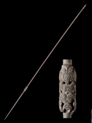
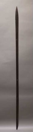
D05851 Speer
Tao
tao
tao
Tao-te-king : = Tao-tê-ching

Harbours of England (The Harbours of England)

Kingstown harbour.
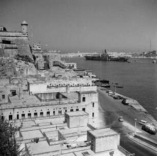
Grand Harbour
Cadiz harbour.
aRRiKiTAO
Sanders, Tao Tao
TAO
D05851 Speer
Tao
tao
tao
Tao-te-king : = Tao-tê-ching
Harbours of England (The Harbours of England)
Kingstown harbour.
Grand Harbour
Cadiz harbour.
aRRiKiTAO
Sanders, Tao Tao
TAO
D05851 Speer
Tao
tao
tao
Tao-te-king : = Tao-tê-ching
Harbours of England (The Harbours of England)
Kingstown harbour.
Grand Harbour