- Alternativer Titel
-
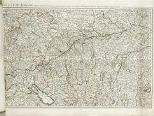
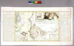
LE COURS DE LA RIVIERE DU RHEIN / depuis sa Source jusques a son Embouchûre / ou sont distingués / TOUS LES ESTATS ET SOUVERAINETÉS
- Standort
-
Deutsches Historisches Museum, Berlin
- Inventarnummer
-
Do 2006/973
- Maße
-
Höhe x Breite: 77,5 x 55,3 cm (Blatt)
Höhe x Breite: 63,7 x 44 cm (Karte)
Höhe x Breite: 66 x 46,5 cm (Platte)
- Material/Technik
-
Papier, Kupferstich, grenzkoloriert
- Klassifikation
-
Kartografie (Gattung)
- Bezug (was)
-
Rhein
- Ereignis
-
Herstellung
- (wer)
-
Geograph, Kartograf: Guillaume Sanson
Geograph, Kartograf, Verleger: Alexis-Hubert Jaillot
Verleger: ? Basset
Stecher: ? Cordier
- (wo)
-
Paris, Frankreich
- (wann)
-
1782
- Rechteinformation
-
Deutsches Historisches Museum
- Letzte Aktualisierung
-
24.03.2023, 09:31 MEZ
Datenpartner
Dieses Objekt wird bereitgestellt von:
Stiftung Deutsches Historisches Museum. Bei Fragen zum Objekt wenden Sie sich bitte an den Datenpartner.
Stiftung Deutsches Historisches Museum. Bei Fragen zum Objekt wenden Sie sich bitte an den Datenpartner.
Objekttyp
- Regionalkarte
Beteiligte
- Geograph, Kartograf: Guillaume Sanson
- Geograph, Kartograf, Verleger: Alexis-Hubert Jaillot
- Verleger: ? Basset
- Stecher: ? Cordier
Entstanden
- 1782
Ähnliche Objekte (12)
Le cours du Danube
Le cours du Rhin
Le cours du Rhin
Carte Topographique du Cours du Rhin
Carte du cours des fleuves du Sénégal. Mit zwei Nebenkarten: Carte de l'entrée de la riviere du Sénégal; Vue de l'isle de Gorée; und drei Plänen: Plan du Fort Saint Joseph; Plan de James-Fort; Plan du Fort St. Louis
Table Geographique dans la quelle fort distinctement est montre la Partie Meridionale ou Superieure du Rhein, Meuse Moselle et les moindres rivieres qui se decharchent dans elles
Cours du Rhin, depuis sa source jusqu'à son embouchure
Carte comprenant le cours du Danube depuis Vienne jusqu'à son embouchure dans la Mer Noire
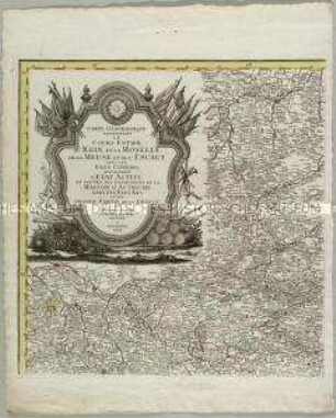
Carte Geographique representant le cours entier du Rhin, de la Moselle, de la Meuse et de l'Escaut
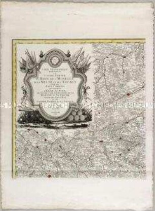
Carte Geographique representant le cours entier du Rhin, de la Moselle, de la Meuse et de l'Escaut
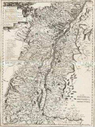
L'Alsace, ou Conquestes du Roy, en Allemagne, tant decà que delà le Rhein
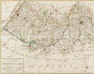
Carte du Departement du Nord
Le cours du Danube
Le cours du Rhin
Le cours du Rhin
Carte Topographique du Cours du Rhin
Carte du cours des fleuves du Sénégal. Mit zwei Nebenkarten: Carte de l'entrée de la riviere du Sénégal; Vue de l'isle de Gorée; und drei Plänen: Plan du Fort Saint Joseph; Plan de James-Fort; Plan du Fort St. Louis
Table Geographique dans la quelle fort distinctement est montre la Partie Meridionale ou Superieure du Rhein, Meuse Moselle et les moindres rivieres qui se decharchent dans elles
Cours du Rhin, depuis sa source jusqu'à son embouchure
Carte comprenant le cours du Danube depuis Vienne jusqu'à son embouchure dans la Mer Noire
Carte Geographique representant le cours entier du Rhin, de la Moselle, de la Meuse et de l'Escaut
Carte Geographique representant le cours entier du Rhin, de la Moselle, de la Meuse et de l'Escaut
L'Alsace, ou Conquestes du Roy, en Allemagne, tant decà que delà le Rhein