Regionalkarte
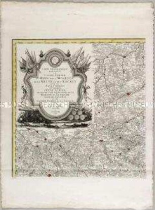
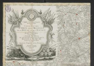
Carte Geographique representant le cours entier du Rhin, de la Moselle, de la Meuse et de l'Escaut
- Alternativer Titel
-
CARTE GEOGRAPHIQUE / REPRESENTANT / LE / COURS ENTIER
- Standort
-
Deutsches Historisches Museum, Berlin
- Inventarnummer
-
Do 2006/960.1-6
- Maße
-
Höhe x Breite: 73 x 59,5 cm (Blatt 1)
Höhe x Breite: 55 x 53 cm (Karte 1)
Höhe x Breite: 58 x 56 cm (Platte 1)
- Material/Technik
-
Papier, Kupferstich, grenzkoloriert
- Klassifikation
-
Kartografie (Gattung)
- Bezug (was)
-
Rhein
Frankreich
Deutschland
Niederlande
Belgien
- Ereignis
-
Herstellung
- (wer)
-
Stecher, Verleger: Matthäus Albrecht Lotter
Stecher: Georg Friedrich Lotter
Stecher, Verleger, Geograph: Tobias Konrad Lotter
- (wo)
-
Augsburg, Deutschland
- (wann)
-
1794
- Rechteinformation
-
Deutsches Historisches Museum
- Letzte Aktualisierung
-
24.03.2023, 09:28 MEZ
Datenpartner
Dieses Objekt wird bereitgestellt von:
Stiftung Deutsches Historisches Museum. Bei Fragen zum Objekt wenden Sie sich bitte an den Datenpartner.
Stiftung Deutsches Historisches Museum. Bei Fragen zum Objekt wenden Sie sich bitte an den Datenpartner.
Objekttyp
- Regionalkarte
Beteiligte
- Stecher, Verleger: Matthäus Albrecht Lotter
- Stecher: Georg Friedrich Lotter
- Stecher, Verleger, Geograph: Tobias Konrad Lotter
Entstanden
- 1794
Ähnliche Objekte (12)
Carte Geographique representant le cours entier du Rhin, de la Moselle, de la Meuse et de l'Escaut

Carte geographique representant le cours entier du Rhin, de la Moselle
Carte Geographique Representant Le Cours Entier Du Rhin, De La Moselle De La Meuse Et De L'Escaut : Avec Les Pays Confins Specialement L'Etat Actuel De Toutes Les Possessions De La Maison D'Autriche Dans Les Pays Bas Et Une Grande Partie De La France
EXTRACTION DE LA RACINE CARRÉE D'UN NOMBRE ENTIER.

Le premier représentant de la double culture.
Fronton de la Place Royalle de Bordeaux, representant La Grandeur des Princes

Explication de la planche représentant les nouveaux ustensiles de cuisine

Embouchure de l'Escaut!
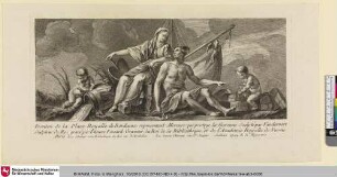
Fronton de la Place Royalle de Bordeaux, representant Mercure qui protege la Garonne
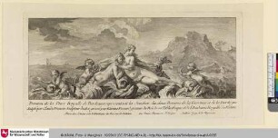
Fronton de la Place Royalle de Bordeaux, representant la Jonction des deux Rivieres
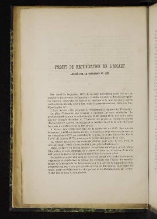
Projet de rectification de l´escaut
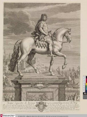
Statuë Equestre de bronze representant la personne du Roy
Carte Geographique representant le cours entier du Rhin, de la Moselle, de la Meuse et de l'Escaut
Carte geographique representant le cours entier du Rhin, de la Moselle
Carte Geographique Representant Le Cours Entier Du Rhin, De La Moselle De La Meuse Et De L'Escaut : Avec Les Pays Confins Specialement L'Etat Actuel De Toutes Les Possessions De La Maison D'Autriche Dans Les Pays Bas Et Une Grande Partie De La France
EXTRACTION DE LA RACINE CARRÉE D'UN NOMBRE ENTIER.
Le premier représentant de la double culture.
Fronton de la Place Royalle de Bordeaux, representant La Grandeur des Princes
Explication de la planche représentant les nouveaux ustensiles de cuisine
Embouchure de l'Escaut!
Fronton de la Place Royalle de Bordeaux, representant Mercure qui protege la Garonne
Fronton de la Place Royalle de Bordeaux, representant la Jonction des deux Rivieres
Projet de rectification de l´escaut