- Alternativer Titel
-
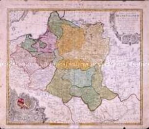
MAPPA TOTIUS REGNI BOHEMIAE/ IN DUODECIM CIRCULOS DIVISAE CUM COMITATU GLACENSI ET DISTRICTU EGRANO etc.
- Standort
-
Deutsches Historisches Museum, Berlin
- Inventarnummer
-
Do 2002/145
- Maße
-
Höhe x Breite: 54 x 59,9 cm (Blatt), Höhe x Breite: 49,3 x 55,4 cm (Platte)
- Material/Technik
-
Papier, Kupferstich, koloriert
- Klassifikation
-
Kartografie (Gattung)
- Bezug (was)
-
Böhmen
- Ereignis
-
Herstellung
- (wer)
-
Kartograf: ? Müller
Verleger: Johannes Covens
Kupferstecher, Verleger: Pieter Mortier
- (wo)
-
Amsterdam [historisch: Amstelodami], Niederlande
- (wann)
-
um 1700
- Rechteinformation
-
Deutsches Historisches Museum
- Letzte Aktualisierung
-
24.03.2023, 09:27 MEZ
Datenpartner
Dieses Objekt wird bereitgestellt von:
Stiftung Deutsches Historisches Museum. Bei Fragen zum Objekt wenden Sie sich bitte an den Datenpartner.
Stiftung Deutsches Historisches Museum. Bei Fragen zum Objekt wenden Sie sich bitte an den Datenpartner.
Objekttyp
- Regionalkarte
Beteiligte
- Kartograf: ? Müller
- Verleger: Johannes Covens
- Kupferstecher, Verleger: Pieter Mortier
Entstanden
- um 1700
Ähnliche Objekte (12)

Mappa Geographica Regnum Bohemiae

Mappa Geographica Regnum Bohemiae
Mappa Geographica Regni Poloniae
Mappa Geographica Regni Poloniae
Regni Bohemiae Circulus Boleslaviensis ex Müllerianis...
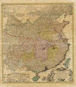
Regni Sinae vel Sinae Propriae Mappa et Descriptio Geographica
Verwaltung der großherzoglichen Gärtnerei und des Parks zu Ettersburg, Parkwärter Müller daselbst
Verlegung des Hoffischbehälters am Residenzschloss; das dem Hoffischer Müller zur Benutzung überlassene Gärtchen an der Burgmühle in Weimar
Vesser : Vesser im Vessertal
Müller, Direktor einer agrikultur-chemischen Versuchsstation
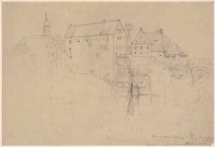
Das Schloss in Lohmen im Liebethaler Grund an der Wesenitz in der Sächsischen Schweiz, von Norden
Brief an den Handwerker Oskar Müller beim 5. Comp Infanterie Regiment Nr. 62 in Cosel (Oberschlesien) von seiner Mutter, mit Briefumschlag, Familienkonvolut Oscar Müller; Breslau, 24. Okt. 1888
Mappa Geographica Regnum Bohemiae
Mappa Geographica Regnum Bohemiae
Mappa Geographica Regni Poloniae
Mappa Geographica Regni Poloniae
Regni Bohemiae Circulus Boleslaviensis ex Müllerianis...
Regni Sinae vel Sinae Propriae Mappa et Descriptio Geographica
Verwaltung der großherzoglichen Gärtnerei und des Parks zu Ettersburg, Parkwärter Müller daselbst
Verlegung des Hoffischbehälters am Residenzschloss; das dem Hoffischer Müller zur Benutzung überlassene Gärtchen an der Burgmühle in Weimar
Vesser : Vesser im Vessertal
Müller, Direktor einer agrikultur-chemischen Versuchsstation
Das Schloss in Lohmen im Liebethaler Grund an der Wesenitz in der Sächsischen Schweiz, von Norden