- Weitere Titel
-
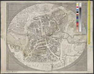
Plan von Berlin
- Standort
-
München, Bayerische Staatsbibliothek -- Bor. 84 h#Kt.-Beil.
- Maße
-
29 x 29 cm
- Umfang
-
1 Kt.
- Sprache
-
Deutsch
- Anmerkungen
-
Kupferstich
Maßstab in graph. Form (Rheinl. Ruthen). - Mit Bergstrichen und städtegeschichlichen Erl.
- Erschienen in
-
Geschichtlich-statistisch-topographisches Taschenbuch von Berlin und seinen nächsten Umgebungen ; Kt.-Beil.
- Schlagwort
-
Berlin
- Ereignis
-
Veröffentlichung
- (wo)
-
Weimar
- (wer)
-
Verlag des geographischen Instituts
- (wann)
-
1830
- Beteiligte Personen und Organisationen
- URN
-
urn:nbn:de:bvb:12-bsb00144982-5
- Letzte Aktualisierung
-
16.04.2025, 08:38 MESZ
Datenpartner
Dieses Objekt wird bereitgestellt von:
Bayerische Staatsbibliothek. Bei Fragen zum Objekt wenden Sie sich bitte an den Datenpartner.
Bayerische Staatsbibliothek. Bei Fragen zum Objekt wenden Sie sich bitte an den Datenpartner.
Objekttyp
- Altkarte
- Stadtplan
Beteiligte
- Mädel, August
- Verlag des geographischen Instituts
Entstanden
- 1830
Ähnliche Objekte (12)
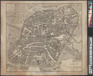
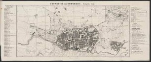
Grundriss von Nürnberg
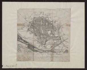
Neuester Grundriss von Prag
![[Grundriss von Nürnberg und seinen Umgebungen]](https://iiif.deutsche-digitale-bibliothek.de/image/2/71853bde-e1a1-45c0-84da-b2da7ef50367/full/!306,450/0/default.jpg)
[Grundriss von Nürnberg und seinen Umgebungen]
Neuer Grundriss Der Stadt Nürnberg
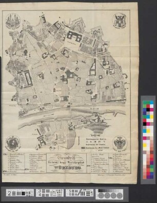
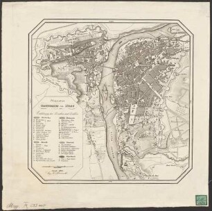
Grundriß der königl. bayer. Kreishauptstadt Würzburg
Grundriss von Nürnberg : in 2 Blättern ; mit den beiden Stadtseiten
Grundriss der Churbaierischen Haupt- und Residenzstadt München

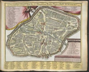
Geometrischer Grundriss der Reichs-Stadt Nürnberg : Anno 1793
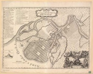
Grundriss der Festung Statt und Situation St. Petersburg
Geometrischer Grund-Riss, des H. Römischen Reichs Freÿen Stadt Nurnberg
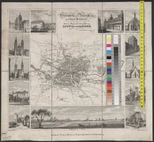
Grundriss von Nürnberg und seinen Umgebungen : Seiner Majestaet dem Könige Ludwig von Bayern in tiefster Ehrfurcht gewidmet vom Verleger
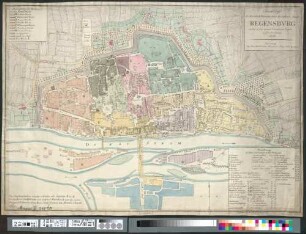
Grundriss der Fürstlich Primatischen Residenz-Stadt Regensburg : nebst deren neuen Gartenanlagen ausser den Thoren
Grundriss von Nürnberg
Neuester Grundriss von Prag
[Grundriss von Nürnberg und seinen Umgebungen]
Neuer Grundriss Der Stadt Nürnberg
Grundriß der königl. bayer. Kreishauptstadt Würzburg
Grundriss von Nürnberg : in 2 Blättern ; mit den beiden Stadtseiten
Grundriss der Churbaierischen Haupt- und Residenzstadt München
Geometrischer Grundriss der Reichs-Stadt Nürnberg : Anno 1793
Grundriss der Festung Statt und Situation St. Petersburg
Geometrischer Grund-Riss, des H. Römischen Reichs Freÿen Stadt Nurnberg
Grundriss von Nürnberg und seinen Umgebungen : Seiner Majestaet dem Könige Ludwig von Bayern in tiefster Ehrfurcht gewidmet vom Verleger