Karten und Pläne
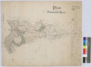
Felderanblümung der Höfe auf Bronnbacher Gemarkung (Inselkarte)
Enthält: Kloster Bronnbach, Schafhof, Mittelhof, Kemmelhof und Hof Wagenbuch im Grundriss
- Reference number
-
Landesarchiv Baden-Württemberg, Abt. Staatsarchiv Wertheim, R-K Nr. 423
- Former reference number
-
Nr. 4
- Dimensions
-
59 x 45 (Höhe x Breite)
- Notes
-
vgl. StAWt-R Lit. B 1164
- Further information
-
Ausführung: Federzeichnung; handkoloriert
Maßstab: [1:13.600]
- Context
-
Karten und Pläne >> B. Baden >> B.22. Wertheim >> B.22.14. Reicholzheim >> B.22.14.1. Bronnbach >> B.22.14.1.7. Gemarkung
- Holding
-
Landesarchiv Baden-Württemberg, Abt. Staatsarchiv Wertheim, R-K Karten und Pläne
- Creator
-
Autor/Fotograf: Füssl
- Date of creation
-
1832
- Other object pages
- View digital item at providers-website
- Rights
-
Es gelten die Nutzungsbedingungen des Landesarchivs Baden-Württemberg.
- Last update
-
26.03.2024, 9:05 AM CET
Data provider
This object is provided by:
Landesarchiv Baden-Württemberg. If you have any questions about the object, please contact the data provider.
Landesarchiv Baden-Württemberg. If you have any questions about the object, please contact the data provider.
Object type
- Karten und Pläne
Associated
- Autor/Fotograf: Füssl
Time of origin
- 1832
Other Objects (12)
Bronnbacher Höfe (Inselkarte)
Felderanblümung der Höfe auf Bronnbacher Gemarkung (Inselkarte)
![[Neueinteilung der Höfe auf Bronnbacher Gemarkung] (Inselkarte)](https://iiif.deutsche-digitale-bibliothek.de/image/2/944ac05d-6c03-4fc9-91a3-dbbb23eef5b9/full/!306,450/0/default.jpg)
[Neueinteilung der Höfe auf Bronnbacher Gemarkung] (Inselkarte)
![[Neuabsteinung der Bronnbacher Gemarkung gegen Höhefeld] (Inselkarte)](https://iiif.deutsche-digitale-bibliothek.de/image/2/50ef1175-b4d2-412d-a523-05ed432f4235/full/!306,450/0/default.jpg)
[Neuabsteinung der Bronnbacher Gemarkung gegen Höhefeld] (Inselkarte)
![[Vermessung der Bronnbacher Gemarkung östlich der Tauber] (Inselkarte)](https://iiif.deutsche-digitale-bibliothek.de/image/2/7e0290fe-dbac-438f-9244-c71d4cccb019/full/!306,450/0/default.jpg)
[Vermessung der Bronnbacher Gemarkung östlich der Tauber] (Inselkarte)
Geometrischer Hauptplan von der Bronnbacher Markung (Inselkarte)
![[Vermessung von Hofplatz und Baumgarten des Bronnbacher Hofs zu Allersheim] (Inselkarte)](https://iiif.deutsche-digitale-bibliothek.de/image/2/b0a28381-3b92-4277-a339-66c8534b2bb1/full/!306,450/0/default.jpg)
[Vermessung von Hofplatz und Baumgarten des Bronnbacher Hofs zu Allersheim] (Inselkarte)

Verjüngte Hauptkarte über die Bronnbacher Markung 1806 (Inselkarte)
![[Neuabsteinung eines Teils der Bronnbacher Gemarkung gegen Reicholzheim und Urphar] (Inselkarte)](https://iiif.deutsche-digitale-bibliothek.de/image/2/fa8e4e1c-9947-4873-a4ad-233561eef17d/full/!306,450/0/default.jpg)
[Neuabsteinung eines Teils der Bronnbacher Gemarkung gegen Reicholzheim und Urphar] (Inselkarte)
![[Hofgut Wagenbuch: Neuabsteinung eines Teils der Bronnbacher Markung] (Inselkarte)](/assets/placeholder/searchResultMediaNoDigitisedMedia.png)
[Hofgut Wagenbuch: Neuabsteinung eines Teils der Bronnbacher Markung] (Inselkarte)
Verjüngte Hauptkarte über die rechterseits der Tauber befindliche Bronnbacher Markung (Inselkarte)
![[Bronnbacher Hof zu Würzburg]](https://iiif.deutsche-digitale-bibliothek.de/image/2/2a044b39-4dc2-417d-8a0e-2edb4307bb85/full/!306,450/0/default.jpg)
[Bronnbacher Hof zu Würzburg]
Bronnbacher Höfe (Inselkarte)
Felderanblümung der Höfe auf Bronnbacher Gemarkung (Inselkarte)
[Neueinteilung der Höfe auf Bronnbacher Gemarkung] (Inselkarte)
[Neuabsteinung der Bronnbacher Gemarkung gegen Höhefeld] (Inselkarte)
[Vermessung der Bronnbacher Gemarkung östlich der Tauber] (Inselkarte)
Geometrischer Hauptplan von der Bronnbacher Markung (Inselkarte)
[Vermessung von Hofplatz und Baumgarten des Bronnbacher Hofs zu Allersheim] (Inselkarte)
Verjüngte Hauptkarte über die Bronnbacher Markung 1806 (Inselkarte)
[Neuabsteinung eines Teils der Bronnbacher Gemarkung gegen Reicholzheim und Urphar] (Inselkarte)
[Hofgut Wagenbuch: Neuabsteinung eines Teils der Bronnbacher Markung] (Inselkarte)
Verjüngte Hauptkarte über die rechterseits der Tauber befindliche Bronnbacher Markung (Inselkarte)