- Reference number
-
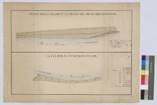
Landesarchiv Baden-Württemberg, Abt. Staatsarchiv Wertheim, R-K Nr. 652
- Dimensions
-
37 x 47 (Höhe x Breite)
- Notes
-
vgl. StAWt-R Lit. C 2211
- Further information
-
Ausführung: Federzeichnung; handkoloriert
Maßstab: 1:2500
- Context
-
Karten und Pläne >> C. Bayern >> C.13. Hafenlohr >> C.13.5. Hafenlohr
- Holding
-
Landesarchiv Baden-Württemberg, Abt. Staatsarchiv Wertheim, R-K Karten und Pläne
- Provenance
-
[Rentamt Wertheim]
- Date of creation
-
[1899]
- Other object pages
- Rights
-
Es gelten die Nutzungsbedingungen des Landesarchivs Baden-Württemberg.
- Last update
-
26.03.2025, 10:04 AM CET
Data provider
This object is provided by:
Landesarchiv Baden-Württemberg. If you have any questions about the object, please contact the data provider.
Landesarchiv Baden-Württemberg. If you have any questions about the object, please contact the data provider.
Object type
- Karten und Pläne
Associated
- [Rentamt Wertheim]
Time of origin
- [1899]
Other Objects (12)
Hofwiese ober Hafenlohr und Langewiese unter Hafenlohr (Inselkarte)
Parzellierung der Hofwiesen von Hafenlohr (Inselkarte)
![Parzellierung des Hoffeldes von Hafenlohr [Teil 2] (Inselkarte)](https://iiif.deutsche-digitale-bibliothek.de/image/2/166ee1ca-2cf8-4f55-b6de-9431525d283d/full/!306,450/0/default.jpg)
Parzellierung des Hoffeldes von Hafenlohr [Teil 2] (Inselkarte)
![Parzellierung des Hoffeldes von Hafenlohr [Teil 1] (Inselkarte)](https://iiif.deutsche-digitale-bibliothek.de/image/2/d2ddb3eb-94bc-422c-8c97-a14369d74d3a/full/!306,450/0/default.jpg)
Parzellierung des Hoffeldes von Hafenlohr [Teil 1] (Inselkarte)

Geometrischer Riss über zwei Fluren des Bauhofs zu Hafenlohr (Inselkarte)
Verjüngter Haupt- und Generalriss über sämtliche Eingehörungen zu dem Hof zu Hafenlohr (Inselkarte)
Hofgut Hafenlohr
Gemarkung Hafenlohr
Hafenlohr: Lauterhof
Hofgut Hafenlohr
Hofgut Hafenlohr
![[Geometrischer Grundriss über die sog. Hofwiese und einen anstoßenden Kleeacker am Main oberhalb des Dorfs Hafenlohr] (Inselkarte)](https://iiif.deutsche-digitale-bibliothek.de/image/2/9293e0fd-0e16-49fa-b227-84b69db9e002/full/!306,450/0/default.jpg)
[Geometrischer Grundriss über die sog. Hofwiese und einen anstoßenden Kleeacker am Main oberhalb des Dorfs Hafenlohr] (Inselkarte)
Hofwiese ober Hafenlohr und Langewiese unter Hafenlohr (Inselkarte)
Parzellierung der Hofwiesen von Hafenlohr (Inselkarte)
Parzellierung des Hoffeldes von Hafenlohr [Teil 2] (Inselkarte)
Parzellierung des Hoffeldes von Hafenlohr [Teil 1] (Inselkarte)
Geometrischer Riss über zwei Fluren des Bauhofs zu Hafenlohr (Inselkarte)
Verjüngter Haupt- und Generalriss über sämtliche Eingehörungen zu dem Hof zu Hafenlohr (Inselkarte)
Hofgut Hafenlohr
Gemarkung Hafenlohr
Hafenlohr: Lauterhof
Hofgut Hafenlohr
Hofgut Hafenlohr