Karte
Topographischer Plan vom Watzmann u. Umgebung : nach A. Waltenbergers Original-Aufnahmen
- Alternative title
-
Topographischer Plan vom Watzmann und Umgebung
- Location
-
München, Bayerische Staatsbibliothek -- Mapp. XI,186 w
- Dimensions
-
49 x 66 cm
- Extent
-
1 Kt.
- Language
-
Deutsch
- Notes
-
Kupferstich
Mit Höhenlinien. - Literatur in: Die Kartographie im Alpenverein, München u.a. 1970. - Erste Kt. d. Alpenvereins im Maßstab 1:25 000
- Keyword
-
Watzmannstock
Watzmann
Berchtesgadener Alpen
Königssee-Gebiet
Wimbachtal
- Event
-
Veröffentlichung
- (where)
-
Hildburghausen
- (who)
-
Petters
- (when)
-
s.a. [1888]
- Contributor
- URN
-
urn:nbn:de:bvb:12-bsb00003942-4
- Last update
-
16.04.2025, 8:43 AM CEST
Data provider
This object is provided by:
Bayerische Staatsbibliothek. If you have any questions about the object, please contact the data provider.
Bayerische Staatsbibliothek. If you have any questions about the object, please contact the data provider.
Object type
- Karte
Associated
- Schmidt, R.
- Waltenberger, Anton
- Petters, Hugo
- Petters
Time of origin
- s.a. [1888]
Other Objects (12)

Königssee, Nationalpark Berchtesgaden, Watzmann

Karte Des Gebietes zwischen Schoa Und Kaffa. Nach den Originalaufnahmen von A. Cecchi Und G. Chiarini.

Topographische Karte, 4720.. Waldeck
Topographischer Atlas Bundesrepublik Deutschland

Zeichen für topographische Gegenstände
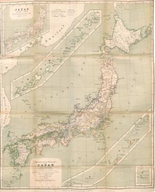
Topographische Karte von Japan
Topographische Karte, 5617.. Usingen
Topographische Karte, 4718.. Goddelsheim
Topographische Karte, 4521.. Liebenau

Topographische Karte der Umgegend von Leipzig
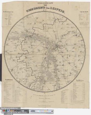
Topographische Karte der Umgegend von Leipzig
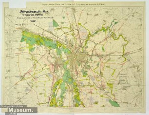
Topographische Karte von Leipzig und Umgebung
Königssee, Nationalpark Berchtesgaden, Watzmann
Karte Des Gebietes zwischen Schoa Und Kaffa. Nach den Originalaufnahmen von A. Cecchi Und G. Chiarini.
Topographische Karte, 4720.. Waldeck
Topographischer Atlas Bundesrepublik Deutschland
Zeichen für topographische Gegenstände
Topographische Karte von Japan
Topographische Karte, 5617.. Usingen
Topographische Karte, 4718.. Goddelsheim
Topographische Karte, 4521.. Liebenau
Topographische Karte der Umgegend von Leipzig
Topographische Karte der Umgegend von Leipzig