Altkarte
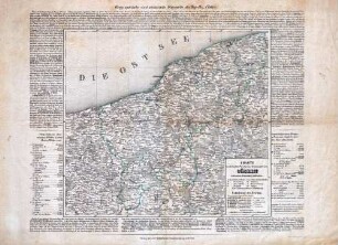
Charte vom Königlich Preussischen Regierungsbezirk Stettin nach seiner Eintheilung in 12 Kreise
Kurzbeschreibung: Einzelkarte
Kartographische Angaben: Nullmeridian Ferro ; Maßstab in graph. Form (geographische Meilen), Graduierung ; Gradnetz
- Location
-
Greifswald
- Collection
-
Kartensammlung des Instituts für Geographie und Geologie (Universität Greifswald)
- Inventory number
-
AltK/I30.00/3
- Measurements
-
36,4 x 32,7 cm (mit Text 41 x 49 cm)
Maßstab ca. 1:560.000
- Material/Technique
-
; Lithographie
- Classification
-
Kartographie
- Subject (where)
-
Erfurt
- Event
-
Herstellung
- (when)
-
o.J. [ca. 1840]
- Last update
-
25.03.2025, 9:45 AM CET
Data provider
This object is provided by:
Universität Greifswald. Kartensammlung des Instituts für Geographie und Geologie. If you have any questions about the object, please contact the data provider.
Universität Greifswald. Kartensammlung des Instituts für Geographie und Geologie. If you have any questions about the object, please contact the data provider.
Object type
- Altkarte
Time of origin
- o.J. [ca. 1840]
Other Objects (12)

Charte vom Königlich Preussischen Regierungsbezirk Minden : nach seiner Eintheilung in 13 Kreise

Charte vom Königlich Preussischen Regierungsbezirk Arnsberg : nach seiner Eintheilung in 14 Kreise

Charte vom Königlich Preussischen Regierungsbezirk Münster : nach seiner Eintheilung in 10 Kreise
Charte vom Königlich Preussischen Regierungsbezirk Cöslin nach seiner Eintheilung in 9 Kreise

Charte vom Königreiche Bayern : nach seiner neuesten Eintheilung vom Jahre 1810

Charte vom Königreiche Bayern : nach den vorzüglichen Hülfsmitteln und der neuesten Kreis-Eintheilung

Charte vom Ober-Donau-Kreis : Mit der Eintheilung in Land- und Herrschafts-Gerichte

Charte vom Königreiche Bayern : nach seinen dermaligen Bestandtheilen, und der neuesten Eintheilung in XV Kreise berichtigt im August 1808

Charte von Europa

Charte vom Königreich Bayern

Charte vom Königreich Bayern

Charte vom Königreich Bayern
Charte vom Königlich Preussischen Regierungsbezirk Minden : nach seiner Eintheilung in 13 Kreise
Charte vom Königlich Preussischen Regierungsbezirk Arnsberg : nach seiner Eintheilung in 14 Kreise
Charte vom Königlich Preussischen Regierungsbezirk Münster : nach seiner Eintheilung in 10 Kreise
Charte vom Königlich Preussischen Regierungsbezirk Cöslin nach seiner Eintheilung in 9 Kreise
Charte vom Königreiche Bayern : nach seiner neuesten Eintheilung vom Jahre 1810
Charte vom Königreiche Bayern : nach den vorzüglichen Hülfsmitteln und der neuesten Kreis-Eintheilung
Charte vom Ober-Donau-Kreis : Mit der Eintheilung in Land- und Herrschafts-Gerichte
Charte vom Königreiche Bayern : nach seinen dermaligen Bestandtheilen, und der neuesten Eintheilung in XV Kreise berichtigt im August 1808
Charte von Europa
Charte vom Königreich Bayern
Charte vom Königreich Bayern
Charte vom Königreich Bayern
Charte vom Königlich Preussischen Regierungsbezirk Minden : nach seiner Eintheilung in 13 Kreise
Charte vom Königlich Preussischen Regierungsbezirk Arnsberg : nach seiner Eintheilung in 14 Kreise
Charte vom Königlich Preussischen Regierungsbezirk Münster : nach seiner Eintheilung in 10 Kreise
Charte vom Königlich Preussischen Regierungsbezirk Cöslin nach seiner Eintheilung in 9 Kreise
Charte vom Königreiche Bayern : nach seiner neuesten Eintheilung vom Jahre 1810
Charte vom Königreiche Bayern : nach den vorzüglichen Hülfsmitteln und der neuesten Kreis-Eintheilung
Charte vom Ober-Donau-Kreis : Mit der Eintheilung in Land- und Herrschafts-Gerichte
Charte vom Königreiche Bayern : nach seinen dermaligen Bestandtheilen, und der neuesten Eintheilung in XV Kreise berichtigt im August 1808
Charte von Europa
Charte vom Königreich Bayern
Charte vom Königreich Bayern