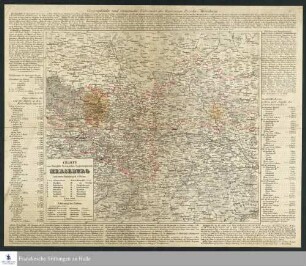
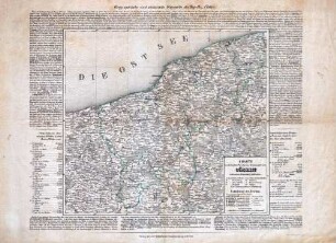
Altkarte
Charte vom Königlich Preussischen Regierungsbezirk Münster : nach seiner Eintheilung in 10 Kreise
- Standort
-
München, Bayerische Staatsbibliothek -- 2 Mapp. 5 wb#Blatt13
- Maße
-
38 x 33 cm
- Umfang
-
1 Kt.
- Sprache
-
Deutsch
- Anmerkungen
-
Lithographie
Maßstab in graph. Form (geographische Meilen)
- Erschienen in
-
Atlas des Königreichs Preussen / B. Wohlmuth ser. u. lith. [Titelblatt] ; [Blatt 13]
- Schlagwort
-
Geschichte 1832
Verwaltungsgrenze
Regierungsbezirk Münster
- Ereignis
-
Veröffentlichung
- (wo)
-
[Erfurt]
- (wer)
-
[Verlag der Müllerschen Buchhandlung]
- (wann)
-
[ca. 1832]
- Beteiligte Personen und Organisationen
- URN
-
urn:nbn:de:bvb:12-bsb00044780-2
- Letzte Aktualisierung
-
27.11.2025, 08:32 MEZ
Datenpartner
Dieses Objekt wird bereitgestellt von:
Bayerische Staatsbibliothek. Bei Fragen zum Objekt wenden Sie sich bitte an den Datenpartner.
Bayerische Staatsbibliothek. Bei Fragen zum Objekt wenden Sie sich bitte an den Datenpartner.
Objekttyp
- Altkarte
Beteiligte
- Renner, L. (Sonstige)
- Kneisel, August (Sonstige)
- [Verlag der Müllerschen Buchhandlung]
Entstanden
- [ca. 1832]
Ähnliche Objekte (12)
Charte vom Königlich Preussischen Regierungsbezirk Merseburg : nach seiner Eintheilung in 17 Kreise
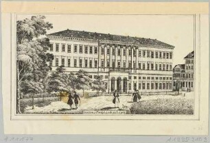
Das 1838 fertiggestellte Neue Postgebäude von Albert Geutebrück auf der Ostseite des Augustusplatz in Leipzig
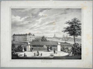
Stadtansicht von Dresden, Blick von der rechten Elbseite in Höhe des Japanischen Palais auf die Altstadt

Charte vom Königlich Preussischen Regierungsbezirk Minden : nach seiner Eintheilung in 13 Kreise
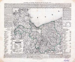
Charte vom Königlich Preussischen Regierungsbezirk Stettin nach seiner Eintheilung in 12 Kreise

Charte vom Königlich Preussischen Regierungsbezirk Arnsberg : nach seiner Eintheilung in 14 Kreise
Charte vom Königlich Preussischen Regierungsbezirk Cöslin nach seiner Eintheilung in 9 Kreise

Hermann, Gottfried Professor in Leipzig
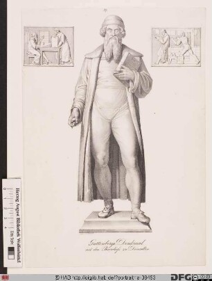
Bildnis Johannes Gutenberg (eig. Gensfleisch zur Laden, gen. G.)
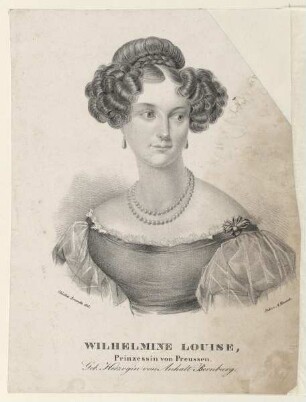
Bildnis der Wilhelmine Louise Prinzessin Brandenburg-Preußen
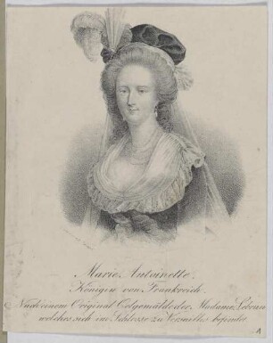
Bildnis der Marie Antoinette, Königin von Frankreich

Bildnis (Johann) Heinrich (Daniel) Zschokke
Charte vom Königlich Preussischen Regierungsbezirk Merseburg : nach seiner Eintheilung in 17 Kreise
Das 1838 fertiggestellte Neue Postgebäude von Albert Geutebrück auf der Ostseite des Augustusplatz in Leipzig
Stadtansicht von Dresden, Blick von der rechten Elbseite in Höhe des Japanischen Palais auf die Altstadt
Charte vom Königlich Preussischen Regierungsbezirk Minden : nach seiner Eintheilung in 13 Kreise
Charte vom Königlich Preussischen Regierungsbezirk Stettin nach seiner Eintheilung in 12 Kreise
Charte vom Königlich Preussischen Regierungsbezirk Arnsberg : nach seiner Eintheilung in 14 Kreise
Charte vom Königlich Preussischen Regierungsbezirk Cöslin nach seiner Eintheilung in 9 Kreise
Hermann, Gottfried Professor in Leipzig
Bildnis Johannes Gutenberg (eig. Gensfleisch zur Laden, gen. G.)
Bildnis der Wilhelmine Louise Prinzessin Brandenburg-Preußen
Bildnis der Marie Antoinette, Königin von Frankreich