Altkarte
Carta Topografica Del Regno Lombardo-Veneto : nach astronomisch-trigonometrischen Vermessungen = Topographische Karte des Lombardisch-Venetianischen Koenigreichs
- Alternative title
-
Topographische Karte des Lombardisch-Venetianischen Koenigreichs
- Location
-
München, Bayerische Staatsbibliothek -- Mapp. XIV,82
- Dimensions
-
Gesamtgr. 340 x 264 cm, gefaltet
- Extent
-
1 Kt. auf 42 Bl.
- Language
-
Italienisch
- Notes
-
Kupferstich
Mit Hangschraffen
- Keyword
-
Lombardo-Venetien
- Event
-
Veröffentlichung
- (where)
-
Mailand
- (when)
-
1833
- URN
-
urn:nbn:de:bvb:12-bsb00107834-3
- Last update
-
16.04.2025, 8:32 AM CEST
Data provider
This object is provided by:
Bayerische Staatsbibliothek. If you have any questions about the object, please contact the data provider.
Bayerische Staatsbibliothek. If you have any questions about the object, please contact the data provider.
Object type
- Altkarte
Time of origin
- 1833
Other Objects (12)
Lombardo-Veneto
a. Recht des lombardisch - venetianischen Königreichs

Zweite Classe. Die venetianischen und lombardischen Schulen.

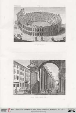
XIII. Zweyte Reise im Lombardisch - Venetianischen Koenigreiche
Zweite Classe. Die venetianischen und lombardischen Schulen.
Corografia dell'Italia Regno Lombardo-Veneto
Die Central- und Provinzial-Kongregationen im lombardisch-venetianischen Königreiche

Kaiserlich Oesterreichisches Patent wegen Errichtung des Lombardisch - Venetianischen Königreichs

Abstempelungen von Lombardei-Venetien : = Timbrature del Lombardo-Veneto
Annali delle science del Regno Lombardo-Veneto. 1845
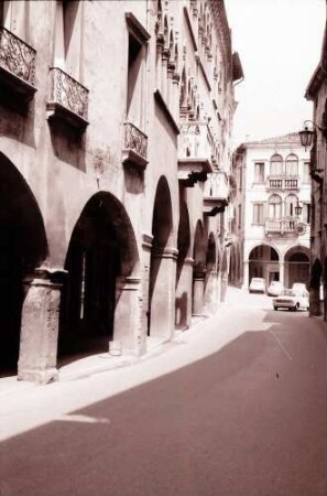
Vittorio Veneto: enge Gasse mit Arkaden und venetianischen Häusern
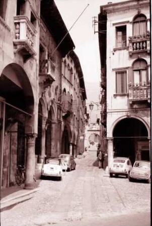
Vittorio Veneto: enge Gasse mit Arkaden und venetianischen Häusern
Lombardo-Veneto
a. Recht des lombardisch - venetianischen Königreichs
Zweite Classe. Die venetianischen und lombardischen Schulen.
XIII. Zweyte Reise im Lombardisch - Venetianischen Koenigreiche
Zweite Classe. Die venetianischen und lombardischen Schulen.
Corografia dell'Italia Regno Lombardo-Veneto
Die Central- und Provinzial-Kongregationen im lombardisch-venetianischen Königreiche
Kaiserlich Oesterreichisches Patent wegen Errichtung des Lombardisch - Venetianischen Königreichs
Abstempelungen von Lombardei-Venetien : = Timbrature del Lombardo-Veneto
Annali delle science del Regno Lombardo-Veneto. 1845
Vittorio Veneto: enge Gasse mit Arkaden und venetianischen Häusern
Vittorio Veneto: enge Gasse mit Arkaden und venetianischen Häusern
Lombardo-Veneto
a. Recht des lombardisch - venetianischen Königreichs
Zweite Classe. Die venetianischen und lombardischen Schulen.
XIII. Zweyte Reise im Lombardisch - Venetianischen Koenigreiche
Zweite Classe. Die venetianischen und lombardischen Schulen.
Corografia dell'Italia Regno Lombardo-Veneto
Die Central- und Provinzial-Kongregationen im lombardisch-venetianischen Königreiche
Kaiserlich Oesterreichisches Patent wegen Errichtung des Lombardisch - Venetianischen Königreichs
Abstempelungen von Lombardei-Venetien : = Timbrature del Lombardo-Veneto
Annali delle science del Regno Lombardo-Veneto. 1845
Vittorio Veneto: enge Gasse mit Arkaden und venetianischen Häusern