Karten und Pläne
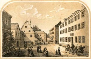
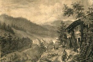
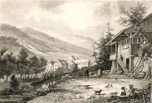
Gemeindewald Rippoldsau Gemarkung Rippoldsau Hofgut Arthur Armbruster
- Reference number
-
Abt. Generallandesarchiv Karlsruhe, 392 Bad Rippoldsau-Schapbach Nr. 346
- Former reference number
-
392 Zugang 2005-47
- Further information
-
Herausgeber: Keine Angaben
Herstellungsort: Keine Angaben
Maßstab: 1:4000
- Context
-
Forstamt Bad Rippoldsau-Schapbach >> Gemeinde- und Körperschaftswald >> Einzelne Gemeinde- und Körperschaftswälder >> Gemeindewald Bad Rippoltsau-Schapbach >> Karten und Pläne
- Holding
-
Landesarchiv Baden-Württemberg, Abt. Generallandesarchiv Karlsruhe, 392 Bad Rippoldsau-Schapbach Forstamt Bad Rippoldsau-Schapbach
- Creator
-
Autor/Fotograf: aufgenommen durch Geometer G. Marquart 1845
- Provenance
-
Forstamt Bad Rippoldsau-Schapbach
- Date of creation
-
1845
- Other object pages
- Rights
-
Es gelten die Nutzungsbedingungen des Landesarchivs Baden-Württemberg.
- Last update
-
2025-04-04T08:08:57+0200
Data provider
This object is provided by:
Landesarchiv Baden-Württemberg. If you have any questions about the object, please contact the data provider.
Landesarchiv Baden-Württemberg. If you have any questions about the object, please contact the data provider.
Object type
- Karten und Pläne
Associated
- Autor/Fotograf: aufgenommen durch Geometer G. Marquart 1845
- Forstamt Bad Rippoldsau-Schapbach
Time of origin
- 1845
Other Objects (12)

Gemeindewald Rippoldsau Gemarkung Rippoldsau Hofgut Xaver Armbruster
Forstamt Bad Rippoldsau-Schapbach Vorbericht Gemeindewald Bad Rippoldsau
Auswanderung: Markus Schoch, Rippoldsau, nach Amerika Alois Armbruster, Rippoldsau, nach Amerika Bonifazius Fleisch, Rippoldsau, nach Amerika Johannes Brüstle, Rippoldsau, nach Amerika
Gemeindewald Bad Rippoldsau Einrichtungswerk
Auswanderung: Stefanie Armbruster, Rippoldsau, nach Amerika
Auswanderung: Engelbert Armbruster, Rippoldsau, nach Amerika
Bad Rippoldsau AG, Rippoldsau/Schwarzwald
Rippoldsau
Rippoldsau
Rippoldsau
Rippoldsau

Rippoldsau
Gemeindewald Rippoldsau Gemarkung Rippoldsau Hofgut Xaver Armbruster
Forstamt Bad Rippoldsau-Schapbach Vorbericht Gemeindewald Bad Rippoldsau
Auswanderung: Markus Schoch, Rippoldsau, nach Amerika Alois Armbruster, Rippoldsau, nach Amerika Bonifazius Fleisch, Rippoldsau, nach Amerika Johannes Brüstle, Rippoldsau, nach Amerika
Gemeindewald Bad Rippoldsau Einrichtungswerk
Auswanderung: Stefanie Armbruster, Rippoldsau, nach Amerika
Auswanderung: Engelbert Armbruster, Rippoldsau, nach Amerika
Bad Rippoldsau AG, Rippoldsau/Schwarzwald
Rippoldsau
Rippoldsau
Rippoldsau
Rippoldsau
Rippoldsau
Gemeindewald Rippoldsau Gemarkung Rippoldsau Hofgut Xaver Armbruster
Forstamt Bad Rippoldsau-Schapbach Vorbericht Gemeindewald Bad Rippoldsau
Auswanderung: Markus Schoch, Rippoldsau, nach Amerika Alois Armbruster, Rippoldsau, nach Amerika Bonifazius Fleisch, Rippoldsau, nach Amerika Johannes Brüstle, Rippoldsau, nach Amerika
Gemeindewald Bad Rippoldsau Einrichtungswerk
Auswanderung: Stefanie Armbruster, Rippoldsau, nach Amerika
Auswanderung: Engelbert Armbruster, Rippoldsau, nach Amerika
Bad Rippoldsau AG, Rippoldsau/Schwarzwald
Rippoldsau
Rippoldsau
Rippoldsau
Rippoldsau