- Location
-
Leibniz-Institut für Länderkunde e.V., Leipzig
- Other number(s)
-
HK 0153 (Signatur)
- Material/Technique
-
unkolor.
- Inscription/Labeling
-
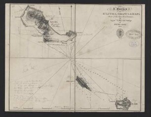
Maßstab in graph. Form (Nautic Miles). - Titel oben rechts. - Verlegerstempel darunter. - Mit 2 Ansichten: View of the Island distant 15 miles & View of the Town and Rocky point, from the anchorage. - Relief: Schraffen
- Subject (what)
-
Altkarte
Kapverdische Inseln
Maio
- Event
-
Veröffentlichung
- (who)
-
Hydrographic Office of the Admiralty (Verlag)
- (where)
-
[London]
- (when)
-
1862
- Rights
-
Leibniz-Institut für Länderkunde e.V.
- Last update
-
15.05.2025, 12:43 PM CEST
Data provider
This object is provided by:
Leibniz-Institut für Länderkunde e. V.. If you have any questions about the object, please contact the data provider.
Leibniz-Institut für Länderkunde e. V.. If you have any questions about the object, please contact the data provider.
Object type
- Karte
Associated
- Hydrographic Office of the Admiralty (Verlag)
Time of origin
- 1862
Other Objects (12)
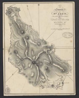
A Survey of St. Jago : (one of the Cape Verd Islands)
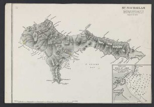
A Survey of St. Nicholas : (One of the Cape Verd Islands)
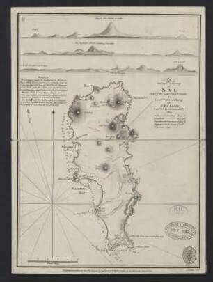
An Orometric Survey of Sal : (one of the Cape Verd Islands)
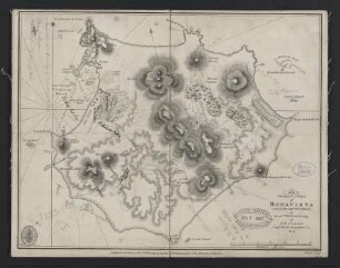
An Orometric Survey of Bonavista : (one of the Cape Verd Islands)
A Survey of St. Lucea, Branco & Raza : (three of the Cape Verd Islands)

A Chart of the Cape Verd Islands
Chapter I. Cape de Verds. - Cape of Good Hope. - Java
Chap. I. Giving an Account of the Canary, Cape Verd ...
Chapter I - St. Jago; Cape de Verd Islands

Chart of the Coast of Barbaria with the Western, Canaria, & Cape De Verd, Isles

Auszeichnungsvorschläge "Verd. Meister" "Verd. Aktivist" "Oberingenieur"

A Mall Intercept Survey on Religion and Worldview in the Cape Flats of Cape Town, South Africa
A Survey of St. Jago : (one of the Cape Verd Islands)
A Survey of St. Nicholas : (One of the Cape Verd Islands)
An Orometric Survey of Sal : (one of the Cape Verd Islands)
An Orometric Survey of Bonavista : (one of the Cape Verd Islands)
A Survey of St. Lucea, Branco & Raza : (three of the Cape Verd Islands)
A Chart of the Cape Verd Islands
Chapter I. Cape de Verds. - Cape of Good Hope. - Java
Chap. I. Giving an Account of the Canary, Cape Verd ...
Chapter I - St. Jago; Cape de Verd Islands
Chart of the Coast of Barbaria with the Western, Canaria, & Cape De Verd, Isles
Auszeichnungsvorschläge "Verd. Meister" "Verd. Aktivist" "Oberingenieur"