Luftbildpläne
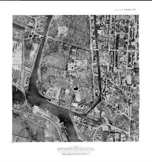
Rethe Hubbrücke, Gauß-Krüger-Koordinaten: Rechtswert: 3564, Hochwert: 5930
- Reference number
-
RW 0230, 20405
- Dimensions
-
Höhe: 60, Breite: 60, Maßstab: 1:2.500
- Context
-
Hansa Luftbild AG, Luftbildpläne 1951-1970 >> 6. Rechswerte beginnend mit 35 >> 6.34. 3564
- Holding
-
RW 0230 Hansa Luftbild AG, Luftbildpläne 1951-1970
- Provenance
-
Hansa Luftbild
- Date of creation
-
22.9.1956, 23.9.1956
- Other object pages
- Delivered via
- Zugangsbeschränkungen
-
Digitalisat vorhanden: Original für die Nutzung gesperrt. Digitalisat vorhanden
- Last update
-
30.04.2025, 3:14 PM CEST
Data provider
This object is provided by:
Landesarchiv Nordrhein-Westfalen. Abteilung Rheinland. If you have any questions about the object, please contact the data provider.
Landesarchiv Nordrhein-Westfalen. Abteilung Rheinland. If you have any questions about the object, please contact the data provider.
Object type
- Luftbildpläne
Associated
- Hansa Luftbild
Time of origin
- 22.9.1956, 23.9.1956
Other Objects (12)

Rethe-Hubbrücke
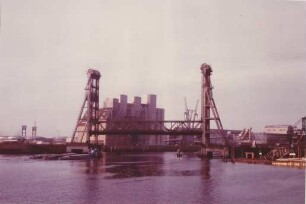
Hubbrücke über Rethe/Hamburg
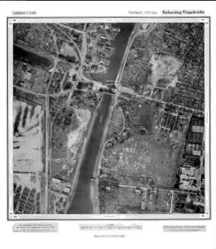
Reiherstieg Klappbrücke, Gauß-Krüger-Koordinaten: Rechtswert: 3564, Hochwert: 5930
Reiherstieg Nord, Gauß-Krüger-Koordinaten: Rechtswert: 3564, Hochwert: 5930
Reiherstieg - Nord, Gauß-Krüger-Koordinaten: Rechtswert: 3564, Hochwert: 5930
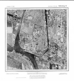
Reiherstieg N, Gauß-Krüger-Koordinaten: Rechtswert: 3564, Hochwert: 5930
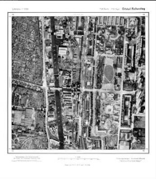
Ortsteil Reiherstieg, Gauß-Krüger-Koordinaten: Rechtswert: 3564, Hochwert: 5930
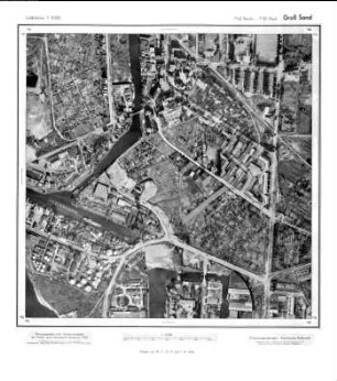
Groß Sand, Gauß-Krüger-Koordinaten: Rechtswert: 3564, Hochwert: 5930
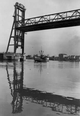
Hamburg. Ansicht der Rethe-Hubbrücke im Hamburger Hafen
Hamburg. Ansicht der Rethe-Hubbrücke im Hamburger Hafen. Aufgenommen 1938
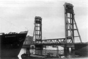
Hamburg. Ansicht der 1934 eröffneten Rethe-Hubbrücke im Hamburger Hafen

Bekanntmachung, betr. Öffnungszeiten der Hafenschleusen, Neuhofer Dreh- und Rethe Hubbrücke
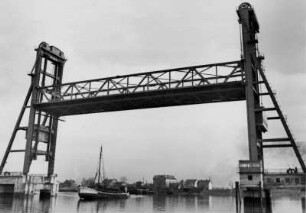
Rethe-Hubbrücke
Hubbrücke über Rethe/Hamburg
Reiherstieg Klappbrücke, Gauß-Krüger-Koordinaten: Rechtswert: 3564, Hochwert: 5930
Reiherstieg Nord, Gauß-Krüger-Koordinaten: Rechtswert: 3564, Hochwert: 5930
Reiherstieg - Nord, Gauß-Krüger-Koordinaten: Rechtswert: 3564, Hochwert: 5930
Reiherstieg N, Gauß-Krüger-Koordinaten: Rechtswert: 3564, Hochwert: 5930
Ortsteil Reiherstieg, Gauß-Krüger-Koordinaten: Rechtswert: 3564, Hochwert: 5930
Groß Sand, Gauß-Krüger-Koordinaten: Rechtswert: 3564, Hochwert: 5930
Hamburg. Ansicht der Rethe-Hubbrücke im Hamburger Hafen
Hamburg. Ansicht der Rethe-Hubbrücke im Hamburger Hafen. Aufgenommen 1938
Hamburg. Ansicht der 1934 eröffneten Rethe-Hubbrücke im Hamburger Hafen
Bekanntmachung, betr. Öffnungszeiten der Hafenschleusen, Neuhofer Dreh- und Rethe Hubbrücke
Rethe-Hubbrücke
Hubbrücke über Rethe/Hamburg
Reiherstieg Klappbrücke, Gauß-Krüger-Koordinaten: Rechtswert: 3564, Hochwert: 5930
Reiherstieg Nord, Gauß-Krüger-Koordinaten: Rechtswert: 3564, Hochwert: 5930
Reiherstieg - Nord, Gauß-Krüger-Koordinaten: Rechtswert: 3564, Hochwert: 5930
Reiherstieg N, Gauß-Krüger-Koordinaten: Rechtswert: 3564, Hochwert: 5930
Ortsteil Reiherstieg, Gauß-Krüger-Koordinaten: Rechtswert: 3564, Hochwert: 5930
Groß Sand, Gauß-Krüger-Koordinaten: Rechtswert: 3564, Hochwert: 5930
Hamburg. Ansicht der Rethe-Hubbrücke im Hamburger Hafen
Hamburg. Ansicht der Rethe-Hubbrücke im Hamburger Hafen. Aufgenommen 1938
Hamburg. Ansicht der 1934 eröffneten Rethe-Hubbrücke im Hamburger Hafen