- Alternativer Titel
-
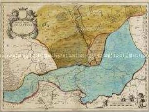
ANHALTINUS/ PRINCIPATUS/ STIRPIS ASCANIENSIS/ felicitate/ hodiè florens/ geographico penicillo/ descriptus/ à/ MATTHAEO SEUTTERO/ GEOGR. CAESAR./ AUG. VINDEL./ Cum Privil: S. Reg: Pol:/ et Elect: Saxon.
- Standort
-
Deutsches Historisches Museum, Berlin
- Inventarnummer
-
Do 2002/118
- Maße
-
Höhe x Breite: 54,4 x 62 cm (Blatt), Höhe x Breite: 50,1 x 57,9 cm (Platte)
- Material/Technik
-
Papier, Kupferstich
- Klassifikation
-
Kartografie (Gattung)
- Bezug (was)
-
Anhalt
- Ereignis
-
Herstellung
- (wer)
-
Kartograf, Geograph: Matthäus Seutter (1678)
Kupferstecher, Verleger: Tobias Konrad Lotter
- (wo)
-
Augsburg [historisch: Augustae Vindelicum], Deutschland [historisch: Heiliges Römisches Reich]
- (wann)
-
um 1750
- Rechteinformation
-
Deutsches Historisches Museum
- Letzte Aktualisierung
-
24.03.2023, 09:29 MEZ
Datenpartner
Dieses Objekt wird bereitgestellt von:
Stiftung Deutsches Historisches Museum. Bei Fragen zum Objekt wenden Sie sich bitte an den Datenpartner.
Stiftung Deutsches Historisches Museum. Bei Fragen zum Objekt wenden Sie sich bitte an den Datenpartner.
Objekttyp
- Regionalkarte
Beteiligte
- Kartograf, Geograph: Matthäus Seutter (1678)
- Kupferstecher, Verleger: Tobias Konrad Lotter
Entstanden
- um 1750
Ähnliche Objekte (12)

Anhaltinus Principatus
Principatus Anhaltinus
Anhaltinus Principatus
Nassovia Principatus
Principatus Anhaldinus
Principatus Isenacensis
Principatus Isenacensis
Principatus Silesiae Oelsnensis
Principatus Saxo-Hildburghusian
Principatus Silesiae Oppaviensis
Principatus Silesiae Saganensis
Principatus Silesiae Munsterbergensis
Anhaltinus Principatus
Principatus Anhaltinus
Anhaltinus Principatus
Nassovia Principatus
Principatus Anhaldinus
Principatus Isenacensis
Principatus Isenacensis
Principatus Silesiae Oelsnensis
Principatus Saxo-Hildburghusian
Principatus Silesiae Oppaviensis
Principatus Silesiae Saganensis