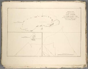
Karte
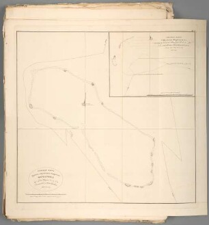
Ploskaja Karta Gruppy Ostrovov" Kornvallisa : Koej srediny Širota 14.° 41.° 59.° N.ja Dolgota 190.° 56.° 28.° W.ja ot" Grenviča Sklonenie Kompasa 10° 28° vost.
- Location
-
Leibniz-Institut für Länderkunde e.V., Leipzig
- Other number(s)
-
HK 1200 - 16 (Signatur)
- Material/Technique
-
unkolor.
- Inscription/Labeling
-
Aus: Atlas" k" Putešestviju Lejtenanta Kocebu Na Korablě Rjurikě V" Južnoe More I V" Beringov" Iroliv" / Otto von Kotzebue. - Titel oben rechts. - Maßstab in graph. Form (Mil' Italianskich"). - Maßstab unten links. - Relief in Schraffen. - In kyrill. Schrift
- Subject (what)
-
Altkarte
Straße
Bering-Straße
- Event
-
Veröffentlichung
- (where)
-
[St. Petersburg]
- (when)
-
1817
- Rights
-
Leibniz-Institut für Länderkunde e.V.
- Last update
-
15.05.2025, 12:43 PM CEST
Data provider
This object is provided by:
Leibniz-Institut für Länderkunde e. V.. If you have any questions about the object, please contact the data provider.
Leibniz-Institut für Länderkunde e. V.. If you have any questions about the object, please contact the data provider.
Object type
- Karte
Time of origin
- 1817
Other Objects (12)
Ploskaja Karta Gruppy Koral'nych" Ostrovov" Čičagova : Koej srediny Širota 9 7 59 N a Dolgota 189 56 30 W.ja ot" Grinviča
28. KARTA RJAZANSKAGO NAMESTNICESTVA / Socin. Al. Vildbrecht. Gr. A. Savinkov
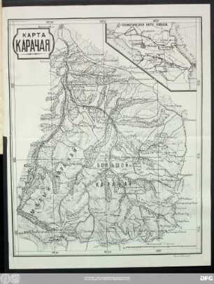
Карта Карачая.

Karta meriatorskaja

Karta sokrovišč
Karta Palestiny
Karta Ekvatorskaja
Ploskaja Karta Gruppy Ostrovov" Grafa Gejdina I Ostrova Novago Goda : Iz" koich" sredina I.oj širota 9.° 51.° 30.° i dol-gota 190.° 46.° 30.° a II. go 10.° 8.° 27.° N i 189.° 4.° 46.° W.vaja ot" Grenviča
190-204, 18. - 28.
Plan" Gruppy Ostrovov" Grafa Arakčeeva : Kabven"
Ploskaja Karta Gruppy Koral'nych" Ostrovov" Grafa Rumjancova : Koej srediny Širota 9.° 26.° 47.° N.ja i Dolgota 189.° 57.° 13.° W.ja ot" Grinviča Sklonenie kompasa 11.° 38 1/2.° vost.
Karta Tecenija Reki Irtyša ot" Omskoj Kreposti do Tobol'ska
Ploskaja Karta Gruppy Koral'nych" Ostrovov" Čičagova : Koej srediny Širota 9 7 59 N a Dolgota 189 56 30 W.ja ot" Grinviča
28. KARTA RJAZANSKAGO NAMESTNICESTVA / Socin. Al. Vildbrecht. Gr. A. Savinkov
Карта Карачая.
Karta meriatorskaja
Karta sokrovišč
Karta Palestiny
Karta Ekvatorskaja
Ploskaja Karta Gruppy Ostrovov" Grafa Gejdina I Ostrova Novago Goda : Iz" koich" sredina I.oj širota 9.° 51.° 30.° i dol-gota 190.° 46.° 30.° a II. go 10.° 8.° 27.° N i 189.° 4.° 46.° W.vaja ot" Grenviča
190-204, 18. - 28.
Plan" Gruppy Ostrovov" Grafa Arakčeeva : Kabven"
Ploskaja Karta Gruppy Koral'nych" Ostrovov" Grafa Rumjancova : Koej srediny Širota 9.° 26.° 47.° N.ja i Dolgota 189.° 57.° 13.° W.ja ot" Grinviča Sklonenie kompasa 11.° 38 1/2.° vost.