- Dimensions
-
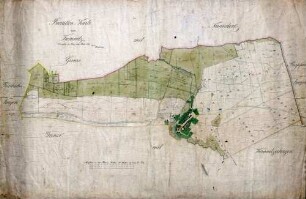
Höhe: 66 cm, Breite: 81 cm, Maßstab: 1:5000
- Context
-
Landesamt für Agrarordnung, Karten Golzheim-Millinger Bruch >> 180. Merheim K. 179
- Holding
-
BR 0142 Landesamt für Agrarordnung, Karten Golzheim-Millinger Bruch
- Date of creation
-
1873
- Other object pages
- Provenance
-
Amt für Agrarordnung Euskirchen
- Delivered via
- Last update
-
17.09.2025, 2:33 PM CEST
Data provider
This object is provided by:
Landesarchiv Nordrhein-Westfalen. Abteilung Rheinland. If you have any questions about the object, please contact the data provider.
Landesarchiv Nordrhein-Westfalen. Abteilung Rheinland. If you have any questions about the object, please contact the data provider.
Object type
- Karten / Pläne
Time of origin
- 1873
Other Objects (12)

Bürgermeisterei Merheim (Bestand)
Brouillon-Karte von Kemnitz
Brouillon-Karte über Hinrichshagen
Brouillon-Karte der Gemeindefeldmark Eichwerder
Brouillon-Karte der Feldmark Granzow
Brouillon-Karte der Feldmark Beenz
Brouillon-Karte ohne nähere Bezeichnung
Brouillon-Karte der Feldmark Frankenfelde
Brouillon-Karte ohne nähere Bezeichnung
Mülheim, Schätzungsverband (Bürgermeisterei Mülheim, Merheim)
(Brouillon-)Karte der Oerlinhauser Senne; Inselkarte
"Brouillon=Karte von der Jonitzer Forst"
Bürgermeisterei Merheim (Bestand)
Brouillon-Karte von Kemnitz
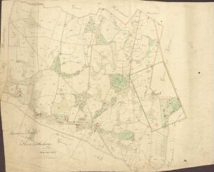
Brouillon-Karte über Hinrichshagen
Brouillon-Karte der Gemeindefeldmark Eichwerder
Brouillon-Karte der Feldmark Granzow
Brouillon-Karte der Feldmark Beenz
Brouillon-Karte ohne nähere Bezeichnung
Brouillon-Karte der Feldmark Frankenfelde
Brouillon-Karte ohne nähere Bezeichnung
Mülheim, Schätzungsverband (Bürgermeisterei Mülheim, Merheim)
(Brouillon-)Karte der Oerlinhauser Senne; Inselkarte