- Location
-
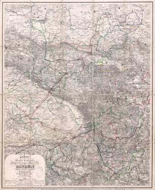
München, Bayerische Staatsbibliothek -- Mapp. X,7 o
- Dimensions
-
70 x 48 cm
- Extent
-
1 Kt.
- Notes
-
Kupferstich
Maßstab in graph. Form (Preussische Meilen)
- Keyword
-
Geschichte 1701-1918
Straßennetz
Preußen
- Event
-
Veröffentlichung
- (where)
-
Berlin
- (who)
-
Simon Schropp
- (when)
-
1827
- Contributor
- URN
-
urn:nbn:de:bvb:12-bsb00122239-8
- Last update
-
16.04.2025, 8:38 AM CEST
Data provider
This object is provided by:
Bayerische Staatsbibliothek. If you have any questions about the object, please contact the data provider.
Bayerische Staatsbibliothek. If you have any questions about the object, please contact the data provider.
Object type
- Altkarte
Associated
- Döring, Ferdinand von
- Kliewer, Heinrich
- Schropp, ...
- Tuch, Wilhelm
- Simon Schropp
Time of origin
- 1827
Other Objects (12)
Europaeisches Russland auch Schweden u. Norwegen : Dabei Uebersicht Des Oesterreichischen u. Preussischen Staats
Karte vom Königlich Preussischen Regierungs-Bezirk Minden ; entworfen und herausgegeben von J.J. Vorlaender
Des Preussischen Herzogthums Vorpommern Nordwestliche Aemter

Des Preussischen Herzogthums Vorpommern Südoestliche Aemter
Das Herzogthum Schlesien Preussischen und Östreichischen Antheils
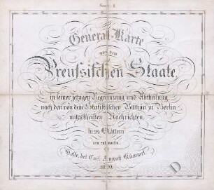
General-Karte von dem Preussischen Staate, in seiner jetzigen Begrenzung und Abtheilung, nach den von dem Statistischen Bureau zu Berlin mitgetheilten Nachrichten in 24 Blättern neu entworfen
Die Markgrafschaft Niederlausitz chursächsischen und preussischen Antheils und in ihre Kreise eingetheilt
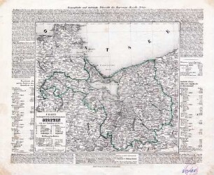
Charte vom Königlich Preussischen Regierungsbezirk Stettin nach seiner Eintheilung in 12 Kreise

Charte vom Königlich Preussischen Regierungsbezirk Minden : nach seiner Eintheilung in 13 Kreise
Charte vom Königlich Preussischen Regierungsbezirk Cöslin nach seiner Eintheilung in 9 Kreise
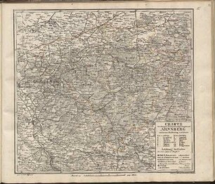
Charte vom Königlich Preussischen Regierungsbezirk Arnsberg : nach seiner Eintheilung in 14 Kreise
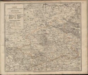
Charte vom Königlich Preussischen Regierungsbezirk Münster : nach seiner Eintheilung in 10 Kreise
Europaeisches Russland auch Schweden u. Norwegen : Dabei Uebersicht Des Oesterreichischen u. Preussischen Staats
Karte vom Königlich Preussischen Regierungs-Bezirk Minden ; entworfen und herausgegeben von J.J. Vorlaender
Des Preussischen Herzogthums Vorpommern Nordwestliche Aemter
Des Preussischen Herzogthums Vorpommern Südoestliche Aemter
Das Herzogthum Schlesien Preussischen und Östreichischen Antheils
General-Karte von dem Preussischen Staate, in seiner jetzigen Begrenzung und Abtheilung, nach den von dem Statistischen Bureau zu Berlin mitgetheilten Nachrichten in 24 Blättern neu entworfen
Die Markgrafschaft Niederlausitz chursächsischen und preussischen Antheils und in ihre Kreise eingetheilt
Charte vom Königlich Preussischen Regierungsbezirk Stettin nach seiner Eintheilung in 12 Kreise
Charte vom Königlich Preussischen Regierungsbezirk Minden : nach seiner Eintheilung in 13 Kreise
Charte vom Königlich Preussischen Regierungsbezirk Cöslin nach seiner Eintheilung in 9 Kreise
Charte vom Königlich Preussischen Regierungsbezirk Arnsberg : nach seiner Eintheilung in 14 Kreise