Physische Karte
Pas-de-Calais
Karte, Mehrfarbdruck auf Papier, ehemalige Seite aus einem Atlas. Karte des nordfranzösischen Département Pas-de-Calais im Maßstab 1:100000. Eingezeichnet ist das Gebiet Pas-de-Calais farbig unterlegt sowie die benachbarten Départements du Nord und de La Somme nebst Städten, Ortschaften, Flüssen, Straßen u.a.
- Location
-
Deutsches Bergbau-Museum Bochum – Leibniz-Forschungsmuseum für Georessourcen
- Collection
-
Karten und Risse
- Inventory number
-
010000517001
- Measurements
-
Höhe: 36,4 cm; Breite: 44,1 cm (Blattmaße)
- Material/Technique
-
Papier *
- Related object and literature
- Subject (where)
-
Frankreich
Département Pas-de-Calais
Courrières
- Event
-
Herstellung
- (who)
-
Lith. Anst. v. J.G. Bach
- (where)
-
Paris
- (when)
-
1879
- (description)
-
Hergestellt
- Event
-
Herstellung
- (who)
-
Lrie Abel Pilon & Cie
- (where)
-
Paris
- (when)
-
1879
- (description)
-
Hergestellt
- Rights
-
Deutsches Bergbau-Museum Bochum – Leibniz-Forschungsmuseum für Georessourcen
- Last update
-
02.11.2023, 1:40 PM CET
Data provider
This object is provided by:
Montanhistorisches Dokumentationszentrum. If you have any questions about the object, please contact the data provider.
Montanhistorisches Dokumentationszentrum. If you have any questions about the object, please contact the data provider.
Object type
- Physische Karte
Associated
- Lith. Anst. v. J.G. Bach
- Lrie Abel Pilon & Cie
Time of origin
- 1879
Other Objects (12)

1.34. Bapaume (Dep. Pas-de-Calais, Frankreich) - Favreuil (Dep. Pas-de-Calais) - Beugnâtre (Dep. Pas-de-Calais, Frankreich) - Beugnies (=Béhagnies (?), Dep. Pas-de-Calais, Frankreich) - Achiet-le-Petit (Dep. Pas-de-Calais, Frankreich)
1.22. Vimy (Dep. Pas-de-Calais, Frankreich) - Thélus (Dep. Pas-de-Calais, Frankreich) - Farbus (Dep. Pas-de-Calais, Frankreich)
1.28. Quéant (Dep. Pas-de-Calais, Frankreich) - Croisilles (Dep. Pas-de-Calais, Frankreich) - Saint-Léger (Dep. Pas-de-Calais, Frankreich)
1.26. Beaurains (Dep. Pas-de-Calais, Frankreich) - Blairville und Umgebung (Dep. Pas-de-Calais, Frankreich) - Neuville-Vitasse (Dep. Pas-de-Calais, Frankreich) - Mercatel (Dep. Pas-de-Calais, Frankreich) - Hendecourt (=Hendecourt-lès-Ransart, Dep. Pas-de-Calais, Frankreich)
1.35. Höhe Grévillers (Dep. Pas-de-Calais, Frankreich) - Buquoy (=Bucquoy, Dep. Pas-de-Calais, Frankreich) - Bihucourt (Dep. Pas-de-Calais, Frankreich)
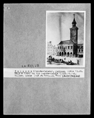
Bapaume (Pas-de-Calais), Rathaus
1.20. Fosse 13 [=Kohlenzeche bei Sallaumines, Dep. Pas-de-Calais, Frankreich] - Meurchin (Dep. Pas-de-Calais, Frankreich) - Pont-à-Vendin (Dep. Pas-de-Calais, Frankreich) - Pont-de-Courrières (bei Courrières (?), Dep. Pas-de-Calais, Frankreich) - Wingles (Dep. Pas-de-Calais, Frankreich)
1.65. Neuve-Chapelle (Dep. Pas-de-Calais, Frankreich) - Richebourg (Dep. Pas-de-Calais, Frankreich)

Landkarte von Südamerika "Carte General du Perou du Haut-Perou, du Chili et de la Plata, dresse par A. Brue, Geographe du Roi, d'apres l'ensemble des observations astronomiques des Espagnols, des Anglais et des Francais"
1.66. Lagnicourt (=Lagnicourt-Marcel, Dep. Pas-de-Calais, Frankreich) - Quéant (Dep. Pas-de-Calais, Frankreich) - Vaulx (=Vaulx-Vraucourt, Dep. Pas-de-Calais, Frankreich)
1.36. Vaulx (=Vaulx-Vraucourt, Dep. Pas-de-Calais, Frankreich) - Mory (Dep. Pas-de-Calais, Frankreich) - Morchies (Dep. Pas-de-Calais, Frankreich) - unbekannte Orte
1.27. Hendecourt (=Hendecourt-lès-Cagnicourt, Dep. Pas-de-Calais, Frankreich) - 'Baireville' (?) - Beaurains (Dep. Pas-de-Calais, Frankreich) - Neuville-Vitasse (Dep. Pas-de-Calais, Frankreich)
1.34. Bapaume (Dep. Pas-de-Calais, Frankreich) - Favreuil (Dep. Pas-de-Calais) - Beugnâtre (Dep. Pas-de-Calais, Frankreich) - Beugnies (=Béhagnies (?), Dep. Pas-de-Calais, Frankreich) - Achiet-le-Petit (Dep. Pas-de-Calais, Frankreich)
1.22. Vimy (Dep. Pas-de-Calais, Frankreich) - Thélus (Dep. Pas-de-Calais, Frankreich) - Farbus (Dep. Pas-de-Calais, Frankreich)
1.28. Quéant (Dep. Pas-de-Calais, Frankreich) - Croisilles (Dep. Pas-de-Calais, Frankreich) - Saint-Léger (Dep. Pas-de-Calais, Frankreich)
1.26. Beaurains (Dep. Pas-de-Calais, Frankreich) - Blairville und Umgebung (Dep. Pas-de-Calais, Frankreich) - Neuville-Vitasse (Dep. Pas-de-Calais, Frankreich) - Mercatel (Dep. Pas-de-Calais, Frankreich) - Hendecourt (=Hendecourt-lès-Ransart, Dep. Pas-de-Calais, Frankreich)
1.35. Höhe Grévillers (Dep. Pas-de-Calais, Frankreich) - Buquoy (=Bucquoy, Dep. Pas-de-Calais, Frankreich) - Bihucourt (Dep. Pas-de-Calais, Frankreich)
Bapaume (Pas-de-Calais), Rathaus
1.20. Fosse 13 [=Kohlenzeche bei Sallaumines, Dep. Pas-de-Calais, Frankreich] - Meurchin (Dep. Pas-de-Calais, Frankreich) - Pont-à-Vendin (Dep. Pas-de-Calais, Frankreich) - Pont-de-Courrières (bei Courrières (?), Dep. Pas-de-Calais, Frankreich) - Wingles (Dep. Pas-de-Calais, Frankreich)
1.65. Neuve-Chapelle (Dep. Pas-de-Calais, Frankreich) - Richebourg (Dep. Pas-de-Calais, Frankreich)
Landkarte von Südamerika "Carte General du Perou du Haut-Perou, du Chili et de la Plata, dresse par A. Brue, Geographe du Roi, d'apres l'ensemble des observations astronomiques des Espagnols, des Anglais et des Francais"
1.66. Lagnicourt (=Lagnicourt-Marcel, Dep. Pas-de-Calais, Frankreich) - Quéant (Dep. Pas-de-Calais, Frankreich) - Vaulx (=Vaulx-Vraucourt, Dep. Pas-de-Calais, Frankreich)
1.36. Vaulx (=Vaulx-Vraucourt, Dep. Pas-de-Calais, Frankreich) - Mory (Dep. Pas-de-Calais, Frankreich) - Morchies (Dep. Pas-de-Calais, Frankreich) - unbekannte Orte