Altkarte
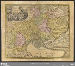
Maris Mediterranei Longitudo Et Latitudo : cum suis Provinciis circumvicinis Geographice exhibita
- Location
-
München, Bayerische Staatsbibliothek -- Hbks/E 33 m-2#Kt.4
- Dimensions
-
34 x 22 cm
- Extent
-
1 Kt.
- Notes
-
Kupferstich
Maßstab in graph. Form (Leucae Germanicae, Leucae Gallicae)
- Bibliographic citation
-
Scherer, Heinrich: [Atlas Novus / 4] ; 4
- Keyword
-
Mittelmeerraum
- Event
-
Veröffentlichung
- (where)
-
[Monachii//München//]
- (who)
-
[Joannis Caspari Bencard]
- (when)
-
1700 [erschienen: 1703]
- URN
-
urn:nbn:de:bvb:12-bsb00105250-1
- Last update
-
16.04.2025, 8:44 AM CEST
Data provider
This object is provided by:
Bayerische Staatsbibliothek. If you have any questions about the object, please contact the data provider.
Bayerische Staatsbibliothek. If you have any questions about the object, please contact the data provider.
Object type
- Altkarte
Associated
- [Joannis Caspari Bencard]
Time of origin
- 1700 [erschienen: 1703]
Other Objects (12)
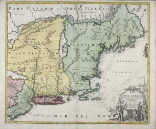
Nova Anglia : Septentrionali Americae implantata Anglorumque coloniis florentissima Geographice exhibita ; Cum Privilegio Sac. Caes. Maj.

Missio Chiloensis Geographice descripta

Missio Chiloensis Geographice descripta
Vkrania quae et terra Cosaccorum cum vicinis Walachiae, Moldaviae, Minoris, Tartariae provinciis exhibita

Bohemia In Suas Partes Geographicé Distincta
Peregrinatio D. Pauli Transmarina Geographice descripta

De Provinciis.
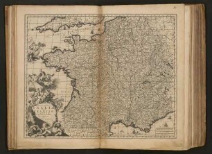
Totius Regni Galliae Sive Franciae Tabula : Cum suis Provinciis, Urbibus, Pagis, Angariis, etc.
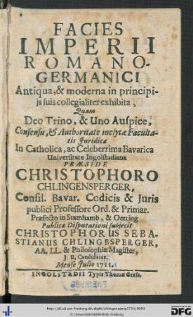
Facies Imperii Romano-Germanici Antiqua, & moderna in principiis suis collegialiter exhibita
Novam Methodvm Regiones Saxosas Geographice Dimetiendi Proponit

De Provinciis Consularibus

De provinciis Italiae
Nova Anglia : Septentrionali Americae implantata Anglorumque coloniis florentissima Geographice exhibita ; Cum Privilegio Sac. Caes. Maj.
Missio Chiloensis Geographice descripta
Missio Chiloensis Geographice descripta
Vkrania quae et terra Cosaccorum cum vicinis Walachiae, Moldaviae, Minoris, Tartariae provinciis exhibita
Bohemia In Suas Partes Geographicé Distincta
Peregrinatio D. Pauli Transmarina Geographice descripta
De Provinciis.
Totius Regni Galliae Sive Franciae Tabula : Cum suis Provinciis, Urbibus, Pagis, Angariis, etc.
Facies Imperii Romano-Germanici Antiqua, & moderna in principiis suis collegialiter exhibita
Novam Methodvm Regiones Saxosas Geographice Dimetiendi Proponit
De Provinciis Consularibus