Grafik
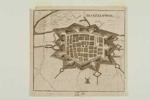
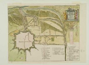
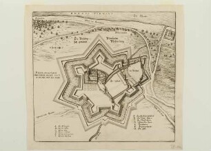
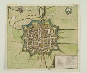
Stadt und Festung Frankenthal
Detail der Sammelkarte: "Pour la Carte Orientale du Palatinat du Rhein" (Stadtgrundrisse von Speier, Mannheim, Worms und Frankenthal)
- Location
-
Universitätsbibliothek Heidelberg
- Collection
-
UB Graphische Sammlung
- Inventory number
-
Graph. Slg. A_0242
- Other number(s)
-
Graph. Slg. VI. 16,2-3 (Kasten S 14) (Alte Inventarnummer)
- Measurements
-
B 20 cm, H 14 cm, Blatt
B 18 cm, H 13 cm, Blatt
B 15,4 cm, H 11 cm, Bild
ca. 44,5 x 33 cm, Passepartout
- Material/Technique
-
Kupferstich, Radierung, koloriert
- Inscription/Labeling
-
Inschrift: PLAN de la Ville de FRANCKENDAL (Inschriftbanner oben links im Bild: Titel und topographische Bezeichung.)
Inschrift: TABLE A [...] O (Abgetrenntes Schriftfeld oben rechts im Bild: Bildlegende)
Inschrift: D.B.F. (unten links am Bild: Initialen des Zeichners/Radierers.)
- Related object and literature
- Classification
-
Kasten 65 (Lokale Systematik)
- Subject (what)
-
Plan
Befestigung
- Subject (where)
-
Frankenthal (Pfalz)
- Event
-
Herstellung
- (when)
-
ca. 1696
- Last update
-
05.03.2025, 4:23 PM CET
Data provider
This object is provided by:
Ruprecht-Karls-Universität Heidelberg. Universitätsbibliothek. If you have any questions about the object, please contact the data provider.
Ruprecht-Karls-Universität Heidelberg. Universitätsbibliothek. If you have any questions about the object, please contact the data provider.
Object type
- Grafik
Time of origin
- ca. 1696
Other Objects (12)
Stadt und Festung Frankenthal
Stadt und Festung Frankenthal
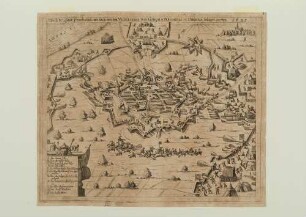
Belagerung der Stadt Frankenthal 1621
Belagerung der Stadt Frankenthal im Jahr 1621
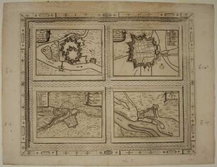
Mannheim, Frankenthal, Germersheim, Kreuznach

Emfpangszeremoniell in Frankenthal 1613 für Friedrich V. und Elisabeth
Festung Philippsburg
Franckenthal, Festung

Festung Königstein

Berglandschaft mit Festung
Gebäudegrundriss Festung Mannheim?
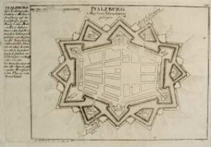
Plan der Festung Pfalzburg
Stadt und Festung Frankenthal
Stadt und Festung Frankenthal
Belagerung der Stadt Frankenthal 1621
Belagerung der Stadt Frankenthal im Jahr 1621
Mannheim, Frankenthal, Germersheim, Kreuznach
Emfpangszeremoniell in Frankenthal 1613 für Friedrich V. und Elisabeth
Festung Philippsburg
Franckenthal, Festung
Festung Königstein
Berglandschaft mit Festung
Gebäudegrundriss Festung Mannheim?