- Alternative title
-
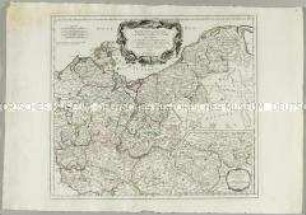
CARTE DE LA / RÉPUBLIQUE FRANÇAISE / DIVISÉE EN 89 DÉPARTEMENS / ET SUBDIVISÉE PAR DISTRICTS,
- Location
-
Deutsches Historisches Museum, Berlin
- Inventory number
-
Do 2006/100
- Measurements
-
Höhe x Breite: 108,5 x 120,5 cm (Blatt)
Höhe x Breite: 98,5 x 110,5 cm (Karte)
Höhe x Breite: 101 x 112,2 cm (Platte)
- Material/Technique
-
Papier, Kupferstich, grenzkoloriert
- Classification
-
Kartografie (Gattung)
- Subject (what)
-
Frankreich
- Event
-
Herstellung
- (who)
-
Geograph, Kartograf: Louis Brion de la Tour (1756)
Geograph, Kartograf: Jean-Baptiste Poirson?
Geograph, Landvermesser: René Phelipeau
Verlag: Esnauts et Rapilly
- (where)
-
Paris, Frankreich
- (when)
-
um 1794
- Rights
-
Deutsches Historisches Museum
- Last update
-
24.03.2023, 3:27 AM CET
Data provider
This object is provided by:
Stiftung Deutsches Historisches Museum. If you have any questions about the object, please contact the data provider.
Stiftung Deutsches Historisches Museum. If you have any questions about the object, please contact the data provider.
Object type
- Kreiskarte
Associated
- Geograph, Kartograf: Louis Brion de la Tour (1756)
- Geograph, Kartograf: Jean-Baptiste Poirson?
- Geograph, Landvermesser: René Phelipeau
- Verlag: Esnauts et Rapilly
Time of origin
- um 1794
Other Objects (12)
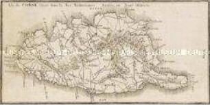
Isle de Corse située dans la Mer Méditerranée Divisée en Neuf Districts

England. Mit einer Nebenkarte: Scilly Inseln
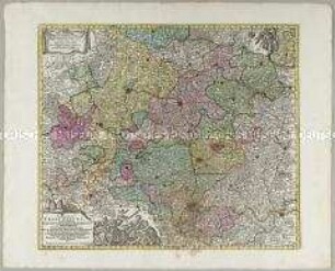
Circulus Franconicus. Mit einer Nebenkarte: Comit. Erbacensis
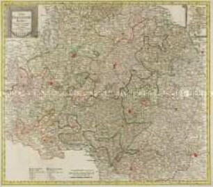
Der Fraenkische Kreis. Mit einer Nebenkarte: Grafsch. Erbach

Der Schwaebische Kreis. Mit einer Nebenkarte: Fürst. Lichtenstein

Die Baierische Monarchie. Mit einer Nebenkarte: Der Rheinkreis
Carte du Gouvernement de Normandie. Mit einer Nebenkarte (Kanalinseln)

Die baierische Monarchie, entworfen in zwey Blättern. Mit einer Nebenkarte: Supplement

Ducatus Wurtenbergici. Mit einer Nebenkarte: Sylvae Herciniae sive Martiae; und zwei Ansichten: Tübingen; Stuttgart

Der Schwaebische Kreis nebst den österreichischen Besizungen in Schwaben. Mit einer Nebenkarte: Fürstent. Lichtenstein
Partie Septentrionale du Cercle de Haute Saxe. Mit einer Nebenkarte: Supplément pour le Marquisat de Brandebourg

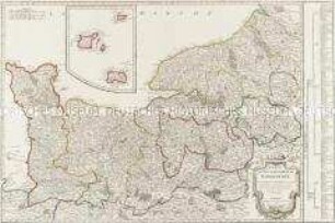
Der Oberrheinische Kreis. Mit einer Nebenkarte: Charte über die am Ober-Rhein zerstreut liegende Länder des Ober-Rheinishen Kreises
Isle de Corse située dans la Mer Méditerranée Divisée en Neuf Districts
England. Mit einer Nebenkarte: Scilly Inseln
Circulus Franconicus. Mit einer Nebenkarte: Comit. Erbacensis
Der Fraenkische Kreis. Mit einer Nebenkarte: Grafsch. Erbach
Der Schwaebische Kreis. Mit einer Nebenkarte: Fürst. Lichtenstein
Die Baierische Monarchie. Mit einer Nebenkarte: Der Rheinkreis
Carte du Gouvernement de Normandie. Mit einer Nebenkarte (Kanalinseln)
Die baierische Monarchie, entworfen in zwey Blättern. Mit einer Nebenkarte: Supplement
Ducatus Wurtenbergici. Mit einer Nebenkarte: Sylvae Herciniae sive Martiae; und zwei Ansichten: Tübingen; Stuttgart
Der Schwaebische Kreis nebst den österreichischen Besizungen in Schwaben. Mit einer Nebenkarte: Fürstent. Lichtenstein
Partie Septentrionale du Cercle de Haute Saxe. Mit einer Nebenkarte: Supplément pour le Marquisat de Brandebourg